SPECIAL ANNOUNCEMENT |
 |
If you are looking for a meaningful gift for a loved one, consider giving an avalanche class... We offer several great learning opportunities in January in Logan including an Advanced Avalanche Skills Workshop on the 5th and 7th, and a Women's Backcountry 101 class on the 12th and 14th. Many other opportunities from across the state are listed on our Education Page.
We now have discount lift tickets available. Go to our Online Store or click this PURCHASE LINK to Backcountry.com who is distributing them for us.
You can show your support by purchasing UAC hardgoods (great xmas gifts!!) through our Online Store from the main menu above. We offer free shipping on everything. |
|
|
BOTTOM LINE
Danger by aspect and elevation on slopes approaching 35° or steeper.
(click HERE for tomorrow's danger rating)
|
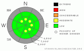
Danger Rose Tutorial
|
There is mostly a Level 1 or Low danger in the backcountry around Logan, and avalanches are generally unlikely. As usual there are exceptions, and a few pockets of level 2 or Moderate danger can be found in steep upper elevation terrain. You could trigger shallow wind slab avalanches on some slopes exposed to drifting. Also, if you venture into steep terrain you are likely to trigger potentially long running, loose dry sluffs. In either case, the greatest risk comes from being swept into shallowly buried rocks or trees below. Mostly safe avalanche conditions exist in the backcountry for now, but you should evaluate the snow and terrain carefully if you travel in steep terrain, especially on exposed upper elevation slopes.... |
|
|
CURRENT CONDITIONS |

|
The snow cover is just too thin for off track riding, and you will likely hit rocks if you venture into untracked snow anywhere but on the smoothest meadows. It is easy to bog down and become stuck in sugary, structureless snow.... The frosty snow surface is fast, so you can do turns and have fun on even very low angled slopes...
The Campbell Scientific Logan Peak weather station at 9700' reports 19 degrees and light winds from the north-northeast this morning. The Tony Grove Snotel at 8400' reports 23 degrees, and there is 29 inches of total snow on the ground.. With 7 inches of water equivalent, the station sits at 66% of average for the date.. |
|
|
RECENT ACTIVITY |

|
We received reports of a couple avalanche incidents in the mountains above Salt Lake City over the weekend. One person was caught and carried by a dry loose sluff, which he triggered.... Apparently things went awry when the sluff pushed him into a rock and a ski released. A ski was lost and the party had to make their way off the hill without it.... The second skier in another party triggered a shallow wind slab on a mid-slope roll with a well placed slope cut. Both avalanches included weak faceted snow formed during the prolonged high pressure system. I haven't received reports of any avalanches locally, but there is certainly lots of weak snow and there will be avalanches when fresh snow piles up on our house of cards.... |
|
|
THREAT #1 |

|
| WHERE |
PROBABILITY |
SIZE |
TREND |
|
|
|
|
| |
|
|
Over the next
24 hours.
|
|
|
You might encounter shallow wind slabs in exposed terrain.... Watch for wind drifted snow on the lee sides of ridges and subridges and in and around terrain features like gullies, scoops, and cliff bands... Even a fairly small avalanche can be quite dangerous if you are caught and carried over shallowly buried rocks below.... |
|
|
THREAT #2 |

|
| WHERE |
PROBABILITY |
SIZE |
TREND |
|
|
|
|
| |
|
|
Over the next
24 hours.
|
|
|
Generally manageable triggered loose dry sluffs involving weak sugary snow are again probable on very steep slopes today, so avoid terrain where you could be swept into gullies, rocks or trees below.. Be sure you are not above or below your partners or other parties, and keep an eye above as you descend. You might be surprised by the quantity of snow involved and the speed at which these sluffs can move especially on a steep and sustained slope.... |
|
|
MOUNTAIN WEATHER |

|
A badly splitting front will pass over our region today, bringing some cloudiness and hopefully stirring up the stagnant air trapped in the valleys... Lower elevation terrain could see a little snowfall today from the low clouds, but you shouldn't expect more than a trace of accumulation. It should be partly cloudy above the valley fog, with mountain temperatures climbing a degree or two above freezing, and we expect light to moderate winds from the east-northeast.... At least there is some snow in the forecast, with around 6 inches of accumulation possible beginning tomorrow night. It could be a goggle day on Wednesday, and even fairly light accumulations will cause a rise in backcountry avalanche danger, with very weak snow currently existing on all aspects and at most elevations..... |
|
|
GENERAL ANNOUNCEMENTS |
Please send us your observations from the backcountry especially if you see or trigger an avalanche, but also even if you don't.. go to avalanche and snow observations. You can also call me directly at 435-757-7578 or leave us a message at our office, 801-524-5304.... And, you can always send us a simple email by clicking HERE
Special message from our partners, the Friends of Utah Avalanche Center: This is a tense time for us. The recession is making it harder to pay for avalanche forecasting in Utah. Many of you have already donated and we deeply appreciate that. Sending in checks, donating online, and coming to the Fall Black Diamond Party or our Pray for Snow fundraiser in Logan– it all helps. As 2011 comes to an end, please consider what daily avalanche information means to your knowledge of what is going on in the mountains, what elevations and aspects are likely to provide best safety and riding conditions, and your understanding of how to avoid avalanches. If this is critical to your life in the mountains, please consider an additional donation and pester your partners - are they stepping up and donating as well? With your help, we can keep this program strong and growing. To donate, go to http://utahavalanchecenter.org/donate Have a great holiday season and stay safe.
I will update this advisory by around 7:30 in the morning on Mondays, Wednesdays, Fridays, and Saturdays.....
This advisory is from the U.S.D.A. Forest Service, which is solely responsible for its content. This advisory describes general avalanche conditions and local variations always occur. |
|
|
This information does not apply to developed ski areas or highways where avalanche control is normally done. This advisory is from the U.S.D.A. Forest Service, which is solely responsible for its content. This advisory describes general avalanche conditions and local variations always occur. |
|
This advisory provided by the USDA Forest Service, in partnership with:
The Friends of the Utah Avalanche Center, Utah Division of State Parks and Recreation, Utah Division of Emergency Management, Salt Lake County, Salt Lake Unified Fire Authority and the friends of the La Sal Avalanche Center. See our Sponsors Page for a complete list. |
