SPECIAL ANNOUNCEMENT |
 |
The Friends of the Utah Avalanche Center in Logan is offering a Backcountry 101 class, starting tonight and including a field day in the backcountry tomorrow. You can still register on line... . click HERE for more details.... |
|
|
BOTTOM LINE
Danger by aspect and elevation on slopes approaching 35° or steeper.
(click HERE for tomorrow's danger rating)
|
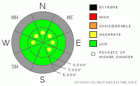
Danger Rose Tutorial
|
There is a Level 1 or Low danger in the backcountry around Logan, and avalanches are generally unlikely. Exceptions and pockets of level 2 or Moderate danger exist in steep upper elevation terrain. Shallow triggered wind slab avalanches are possible on a few slopes exposed to drifting. More dangerous and deeper old wind slabs are unlikely but possible on isolated very steep slopes with poor snow structure on the highest peaks. Generally manageable, but potentially long running, triggered loose dry sluffs are again probable on very steep slopes. Generally safe avalanche conditions exist in the backcountry for now, but you should evaluate the snow and terrain carefully in steep areas, especially on exposed upper elevation slopes.. |
|
|
CURRENT CONDITIONS |

|
Conditions are still too shallow for off-track powder riding, and I've been sticking to roadways and following your tracks in the smooth upper elevation meadows. You have to keep your speed down because you sink pretty deeply into sugary recrystallized snow, and it's quite easy to hit buried rocks, stumps, or down trees... Sunny slopes sport crusty surface snow, but you can find enjoyable although droppy, Colorado-like turning on shaded slopes. The snow is fast making even very low angled slopes pretty fun...
The Tony Grove Snotel at 8400' reports 19 degrees this morning, and there is 30 inches of total snow on the ground.. With 6.9 inches of water equivalent, the station sits at 70% of average for the date..It's 14 degrees at the 9700' CSI Logan Peak weather station, and there is a northwest wind averaging in the mid teens.. |
|
|
RECENT ACTIVITY |

|
I triggered a shallow wind slab yesterday near the ridge in the Hunter's Cave Area. The small soft slab on an east facing slope at around 9500' in elevation was 4 to 6 inches deep and around 20 feet wide, and it stopped after running only a few feet. I'm thinking there could be a few more of these little slabs scattered about, and some could be a bit bigger... |
|
|
THREAT #1 |

|
| WHERE |
PROBABILITY |
SIZE |
TREND |

|
|
|
|
| |
|
|
Over the next
12 hours.
|
|
|
You might encounter fresh shallow wind slabs in exposed terrain, and this danger will increase if winds pick up. Watch for drifted fresh snow on the lee sides of ridges and subridges and in and around terrain features like gullies, scoops, and cliff bands... Deeper old wind slabs are unlikely but possible on very steep isolated upper elevation slopes with poor snow structure. The danger of being caught in even a small early season avalanche is greatly increased by the shallowly buried and exposed rocks you could be raked over... |
|
|
THREAT #2 |

|
| WHERE |
PROBABILITY |
SIZE |
TREND |

|
|
|
|
| |
|
|
Over the next
24 hours.
|
|
|
Generally manageable triggered loose dry sluffs involving weak sugary snow are again probable on very steep slopes today, so avoid terrain where you could be swept into gullies, rocks or trees below.. You might be surprised by the quantity of snow involved and the speed at which these sluffs can move especially on a steep and sustained slope.... |
|
|
MOUNTAIN WEATHER |

|
Looks like a return to mostly sunny and warmer weather in the mountains for the weekend... Expect sunny skies with 8000' high temperatures around 29 degrees and a light northwest wind today. It will be around 10 degrees warmer in the mountains tomorrow and the winds are supposed to stay fairly light. The next in the seemingly endless stream of splitting storms will affect the zone on Monday with a slight chance of accumulating snow. A better chance of this comes late Wednesday into Thursday, but significant snowfall will likely not occur before Christmas. |
|
|
GENERAL ANNOUNCEMENTS |
You have the opportunity to participate in the creation of our own community avalanche advisory by submitting avalanche and snow observations. You can also call us at 435-757-7578 or 801-524-5304 or email by clicking HERE
Donate to your favorite non-profit – The Friends of the Utah Avalanche Center. The UAC depends on contributions from users like you to support our work.
I will update this advisory by around 7:30 in the morning on Mondays, Wednesdays, Fridays, and Saturdays.....
This advisory is from the U.S.D.A. Forest Service, which is solely responsible for its content. This advisory describes general avalanche conditions and local variations always occur. |
|
|
This information does not apply to developed ski areas or highways where avalanche control is normally done. This advisory is from the U.S.D.A. Forest Service, which is solely responsible for its content. This advisory describes general avalanche conditions and local variations always occur. |
|
This advisory provided by the USDA Forest Service, in partnership with:
The Friends of the Utah Avalanche Center, Utah Division of State Parks and Recreation, Utah Division of Emergency Management, Salt Lake County, Salt Lake Unified Fire Authority and the friends of the La Sal Avalanche Center. See our Sponsors Page for a complete list. |
