SPECIAL ANNOUNCEMENT |
 |
Come support the Friends of the Utah Avalanche Center in Logan Thursday December 15th at 7:30 pm at the Logan Arthouse and Cinema. We'll be showing KGB's newest film "Wyoming Triumph.' Admission is $10 and tickets can be pre-purchased at http://utahavalanchecenter.org/wyoming_triumph/120611. We'll have a raffle of great gear to support the Friends, so come and get some relief from Finals and enjoy the show! Call 757-2794 for more info. |
|
|
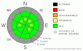
BOTTOM LINE
Danger by aspect and elevation on slopes approaching 35° or steeper.
(click HERE for tomorrow's danger rating)
|
Danger Rose Tutorial
|
There is a Level 1 or Low danger in the backcountry around Logan, and avalanches are generally unlikely. However exceptions exist in steep terrain, and I've included a few pockets of level 2 or Moderate danger at upper elevations. Generally manageable, but potentially long running, triggered loose dry sluffs are likely on steep slopes. Shallow triggered wind slab avalanches are also possible on some drifted upper elevation slopes, and this danger will increase with any increase in winds. Generally safe avalanche conditions exist in the backcountry, but you should evaluate the snow and terrain carefully in steep areas, especially on exposed upper elevation slopes.. |
|
|
CURRENT CONDITIONS |

|
The Tony Grove Snotel at 8400' reports 20 degrees this morning, and there is 30 inches of total snow on the ground.. With 6.9 inches of water equivalent, the station sits at 74% of average for the date.. It's 13 degrees at the 9700' CSI Logan Peak weather station, and there is a northwest wind averaging in the lower teens..
An inch of new snow helped a bit, but overall snow conditions are still very shallow in the backcountry. Conditions aren't very good for powder riding, and I've been sticking to roadways and smooth meadows. You have to keep your speed down because you sink pretty deeply into the recrystallized snow, and it's quite easy to hit buried rocks, stumps, or down trees.... We've received reports of very difficult trail breaking conditions in areas that have not yet been tracked due to the unconsolidated sugary or faceted snow.... |
|
|
RECENT ACTIVITY |

|
We received several reports of long running sluffs and a few shallow wind slabs in the Central Wasatch, and one person triggered and was caught and carried a little ways by a shallow wind slab on a steep slope in Little Cottonwood Canyon. With about half as much new snow locally, activity has been limited to easily triggered and fairly long running loose sluffs on steep slopes in the Logan Zone.... Some of these included more snow and ran a bit farther than expected... |
|
|
THREAT #1 |

|
| WHERE |
PROBABILITY |
SIZE |
TREND |

|
|
|
|
| |
|
|
Over the next
12 hours.
|
|
|
Generally manageable loose dry sluffs involving weak surface snow and the fresh inch or two of snow from yesterday are again likely on steep slopes today, so avoid terrain where you could be swept into gullies, rocks or trees below.. You might be surprised by the quantity of snow involved and the speed at which these sluffs can move especially on a steep and sustained slope. |
|
|
THREAT #2 |

|
| WHERE |
PROBABILITY |
SIZE |
TREND |

|
|
|
|
| |
|
|
Over the next
24 hours.
|
|
|
You might encounter fresh shallow wind slabs in exposed terrain, and this danger will increase if winds pick up at all... Watch for drifted fresh snow on the lee sides of ridges and subridges and in and around terrain features like gullies, scoops, and cliff bands... The danger of being caught in even a shallow early season avalanche is greatly increased by the shallowly buried and exposed rocks you could be raked over... |
|
|
MOUNTAIN WEATHER |

|
We'll see mostly cloudy and chilly conditions in the mountains, with 8000' high temperatures forecast at around 17 degrees, a westerly breeze, and a chance for a few snowflakes.. Expect cloudy conditions, chilly temperatures and a southwest wind tomorrow. The storm forecast for tomorrow night is largely a flop, and we'll be lucky to get and inch or two from it.... Looks like a return to mostly sunny and warmer weather in the mountains for the weekend... |
|
|
GENERAL ANNOUNCEMENTS |
The Friends of the Utah Avalanche Center in Logan is offering a Backcountry 101 class next weekend... The class starts with a classroom session on Friday evening, and includes a field day in the backcountry on Saturday. click HERE for more details....
You have the opportunity to participate in the creation of our own community avalanche advisory by submitting avalanche and snow observations. You can also call us at 435-757-7578 or 801-524-5304 or email by clicking HERE
Donate to your favorite non-profit – The Friends of the Utah Avalanche Center. The UAC depends on contributions from users like you to support our work.
I will update this advisory by around 7:30 in the morning on Mondays, Wednesdays, Fridays, and Saturdays.....
This advisory is from the U.S.D.A. Forest Service, which is solely responsible for its content. This advisory describes general avalanche conditions and local variations always occur. |
|
|
This information does not apply to developed ski areas or highways where avalanche control is normally done. This advisory is from the U.S.D.A. Forest Service, which is solely responsible for its content. This advisory describes general avalanche conditions and local variations always occur. |
|
This advisory provided by the USDA Forest Service, in partnership with:
The Friends of the Utah Avalanche Center, Utah Division of State Parks and Recreation, Utah Division of Emergency Management, Salt Lake County, Salt Lake Unified Fire Authority and the friends of the La Sal Avalanche Center. See our Sponsors Page for a complete list. |
