SPECIAL ANNOUNCEMENT |
 |
Come support the Friends of the Utah Avalanche Center in Logan next Thursday December 16th at 7:30 pm at the Logan Arthouse and Cinema. We'll be showing KGB's newest film "Wyoming Triumph.' Admission is $10 and tickets can be pre-purchased at http://utahavalanchecenter.org/wyoming_triumph/120611. We'll have a raffle of great gear to support the Friends, so come and get some relief from Finals and enjoy the show! Call 757-2794 for more info.
The Friends of the Utah Avalanche Center in Logan is offering a Backcountry 101 class next weekend... The class starts with a classroom session on Friday evening, and includes a field day in the backcountry on Saturday. click HERE for more details.... |
|
|
BOTTOM LINE
Danger by aspect and elevation on slopes approaching 35° or steeper.
(click HERE for tomorrow's danger rating)
|
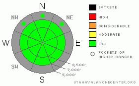
Danger Rose Tutorial
|
There is a Level 1 or Low danger in the backcountry around Logan, and avalanches are generally unlikely. However exceptions still exist in very steep terrain. Generally manageable triggered loose dry sluffs and exceptional wind slab avalanches are possible on some isolated upper elevation drifted slopes. Generally safe avalanche conditions exist in the backcountry, but you should still watch out for unstable snow on very steep slopes especially in exposed upper elevation terrain.. |
|
|
CURRENT CONDITIONS |

|
The Tony Grove Snotel at 8400' reports 24 degrees this morning, and there is 29 inches of total snow on the ground.. With 6.8 inches of water equivalent, the station sits at 76% of average for the date.. It's 19 degrees at the 9700' CSI Logan Peak weather station, and there is a south wind averaging in the mid twenties.. You'll find pretty fun, fast, and loud sugar snow conditions in many areas. But, you have to keep your speed down because you sink pretty deeply into the recrystallized snow, and it's getting easier and easier to hit buried rocks, stumps, or down trees.... Observers report well developed surface hoar on many aspects and all elevations this weekend. |
|
|
RECENT ACTIVITY |

|
No new avalanches reported recently in the mountains of Northern Utah.
We continue monitoring the gradually deteriorating shallow snowpack as high pressure conditions and cold air temperatures are causing it to weaken significantly. The shallow snow is subjected to an extreme temperature gradient when the air temperature is cold, and clear skies allow for significant longwave radiational loss. A temperature gradient drives sublimation of water vapor through the snowpack, which transforms the snow crystals into weak sugary non-cohesive grains called facets. Meanwhile, water vapor near the snow surface freezes and becomes frost or feathery surface hoar. The bottom line is; given the existence of all this extremely weak snow, we'll see a widespread and serious persistent avalanche problem when a slab is finally built by accumulating snow, especially with the next significant dump. |
|
|
THREAT #1 |

|
| WHERE |
PROBABILITY |
SIZE |
TREND |

|
|
|
|
| |
|
|
Over the next
12 hours.
|
|
|
Generally manageable loose dry sluffs involving weak surface snow are likely on steep slopes today, so avoid terrain where you could be swept into rocks or trees below..There may be a rouge wind slab or two out there that you might trigger in very steep drifted terrain. Obviously, the consequence of being caught in an early season avalanche is greatly increased by the shallowly buried and exposed rocks you could be raked over... |
|
|
MOUNTAIN WEATHER |

|
We'll see partly sunny conditions in the mountains today, with the 8000' high temperature forecast to be around 29 degrees and a south breeze... A low pressure system will develop off the coast of southern California today, and it will eject moisture and snow into southern and perhaps central Utah as it gradually moves eastward in the first half of the week.. We will only see increasing clouds up in the north... Another storm will drop into the Great Basin in the later half of the week, but confidence remains low as to it's path and timing.. The forecast beyond midweek is filled with uncertainty, so we might not see a break in the inversion and more powder in the mountains for a while..... |
|
|
GENERAL ANNOUNCEMENTS |
 You have the opportunity to participate in the creation of our own community avalanche advisory by submitting avalanche and snow observations. You can also call us at 435-757-7578 or 801-524-5304 or email by clicking HERE You have the opportunity to participate in the creation of our own community avalanche advisory by submitting avalanche and snow observations. You can also call us at 435-757-7578 or 801-524-5304 or email by clicking HERE
Donate to your favorite non-profit – The Friends of the Utah Avalanche Center. The UAC depends on contributions from users like you to support our work.
I will update this advisory by around 7:30 in the morning on Mondays, Wednesdays, Fridays, and Saturdays.....
This advisory is from the U.S.D.A. Forest Service, which is solely responsible for its content. This advisory describes general avalanche conditions and local variations always occur. |
|
|
This information does not apply to developed ski areas or highways where avalanche control is normally done. This advisory is from the U.S.D.A. Forest Service, which is solely responsible for its content. This advisory describes general avalanche conditions and local variations always occur. |
|
This advisory provided by the USDA Forest Service, in partnership with:
The Friends of the Utah Avalanche Center, Utah Division of State Parks and Recreation, Utah Division of Emergency Management, Salt Lake County, Salt Lake Unified Fire Authority and the friends of the La Sal Avalanche Center. See our Sponsors Page for a complete list. |
