BOTTOM LINE
Danger by aspect and elevation on slopes approaching 35° or steeper.
(click HERE for tomorrow's danger rating)
|
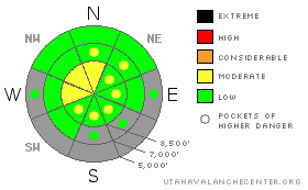
Danger Rose Tutorial
|
There is a Level 1 or Low danger on most slopes in the region, and avalanches are generally unlikely. However, heightened avalanche conditions exist on some steep drifted slopes at upper elevations and on canyon walls. In these areas there is a level 2 or Moderate danger and you might trigger wind slab avalanches. Pockets of level 2 and heightened avalanche conditions also remain on isolated northerly facing slopes at the highest elevations where you might trigger dangerous avalanches failing on weak basal snow near the ground. You should continue to evaluate the snow and terrain carefully, especially in drifted upper elevation terrain.... |
|
|
CURRENT CONDITIONS |

|
The Tony Grove Snotel at 8400' reports 4 new inches of light snow since yesterday, containing 2/10ths of an inch of water. It's negative 1 degree this morning, and there is 33 inches of total snow on the ground.. It's a chilly -3 degrees at the 9700' CSI Logan Peak weather station, and I'm still reading light easterly winds this morning... East winds picked up again yesterday, with hourly averages around 30 mph for several hours... Expect very cold air temperatures and extreme (well subzero) wind-chills despite clear and sunny conditions in the mountains today. |
|
|
RECENT ACTIVITY |

|
No new avalanches were reported from over the weekend.. We are monitoring the current shallow snowpack as high pressure conditions and cold air temperatures are causing it to weaken significantly. Since the snow is shallow in many areas, it is subjected to an extreme temperature gradient when the air temperature is cold. A temperature gradient drives sublimation of water vapor through the snowpack, which transforms the snow crystals into weak sugary non-cohesive grains called facets. We need snow, but unfortunately when we get a significant dump we'll be cursed by dangerous persistent weak layers that are forming now.... |
|
|
THREAT #1 |

|
| WHERE |
PROBABILITY |
SIZE |
TREND |
|
|
|
|
| |
|
|
Over the next
12 hours.
|
|
|
Watch for recently formed wind slabs in exposed terrain and near canyon mouths.... Avoid rounded, chalky looking, or hollow sounding drifts on steep slopes and in and around terrain features... Wind slabs formed in somewhat unusual places due to a few recent easterly wind events... |
|
|
THREAT #2 |

|
| WHERE |
PROBABILITY |
SIZE |
TREND |

|
|
|
|
| |
|
|
Over the next
24 hours.
|
|
|
Be especially wary in drifted rocky or shallow areas that held October snow before the big mid November storms. You might trigger a dangerous avalanche running on weak basal snow from an area where the slab is thinner and more reactive to your weight. Obviously, the consequence of being caught in an early season avalanche is greatly increased by the shallowly buried and exposed rocks you could be raked over... |
|
|
MOUNTAIN WEATHER |

|
You'll find clear and sunny, but very cold conditions in the mountains today. High temperatures at 8000' are forecast to stay in the single digits, and a continuing easterly breeze will keep wind chill factors well below zero in exposed terrain.... Keep an eye on your own and your partners' exposed skin, monitoring for potential frostbite... Expect to see gradual warming this week under well established high pressure conditions.... A weak cold front is forecast to swing through the region on around Thursday, but at this point it doesn't look like it'll produce much snow before the high pressure builds back into the area... |
|
|
GENERAL ANNOUNCEMENTS |
Thanks to all who attended, donated, and helped to put on our annual fundraiser party Wednesday night. It was a big success thanks to you!
You have the opportunity to participate in the creation of our own community avalanche advisory by submitting avalanche and snow observations. You can also call us at 435-757-7578 or 801-524-5304 or email by clicking HERE
Donate to your favorite non-profit – The Friends of the Utah Avalanche Center. The UAC depends on contributions from users like you to support our work.
I will update this advisory by around 7:30 in the morning on Mondays, Wednesdays, Fridays, and Saturdays.....
This advisory is from the U.S.D.A. Forest Service, which is solely responsible for its content. This advisory describes general avalanche conditions and local variations always occur. |
|
|
This information does not apply to developed ski areas or highways where avalanche control is normally done. This advisory is from the U.S.D.A. Forest Service, which is solely responsible for its content. This advisory describes general avalanche conditions and local variations always occur. |
|
This advisory provided by the USDA Forest Service, in partnership with:
The Friends of the Utah Avalanche Center, Utah Division of State Parks and Recreation, Utah Division of Emergency Management, Salt Lake County, Salt Lake Unified Fire Authority and the friends of the La Sal Avalanche Center. See our Sponsors Page for a complete list. |
