BOTTOM LINE
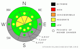
Danger by aspect and elevation on slopes approaching 35° or steeper.
(click HERE for tomorrow's danger rating)
|
Danger Rose Tutorial
|
There is a level 2 or Moderate danger mainly at upper elevations in the backcountry. Heightened avalanche conditions exist and you might trigger wind slab avalanches on some drifted slopes where the somewhat unusual easterly winds Thursday and again this morning deposited fresh and stiff wind slabs on weak and sugary preexisting surface snow. Heightened avalanche conditions also remain on a few steep northerly facing slopes at the highest elevations where you might trigger very dangerous persistent slab avalanches failing on weak basal snow near the ground. Avoid drifted rocky areas with generally shallower snow cover. There is a level 1 or Low danger on most other slopes in the backcountry today. You should continue to evaluate the snow and terrain carefully, especially in drifted upper elevation terrain.... |
|
|
CURRENT CONDITIONS |

|
You'll find a couple inches of fresh light snow in the backcountry, which will freshen up the crusty and wind hammered snow surface a bit. Look for the softer, less wind-wrecked snow in sheltered terrain today... Expect to find significant scoured-off areas near exposed ridges, with hard wind deposited snow on the lee (normally windward) sides...It's still a bit boney for backcountry riding, but at least you can see most of the obstacles sticking out through the mostly supportable but seasonally shallow snow.
The Tony Grove Snotel at 8400' reports 4 new inches of light snow since yesterday, containing 2/10ths of an inch of water. It's 13 degrees this morning, and there is 33 inches of total snow on the ground.. It's a chilly 4 degrees at the 9700' CSI Logan Peak weather station, and easterly winds picked up again overnight, with 30 + mph averages and a gust of 52 mph from the east-northeast early this morning. |
|
|
RECENT ACTIVITY |

|
We could see signs of a few shallow natural avalanches from the 12-1-2011 wind storm on upper elevation slopes, but the strong east winds had scoured most of the evidence away.... |
|
|
THREAT #1 |

|
| WHERE |
PROBABILITY |
SIZE |
TREND |

|
|
|
|
| |
|
|
Over the next
12 hours.
|
|
|
On some slopes, slabs built on weak sugary snow that was previously on or near the snow surface and preserved by a thin sun-crust or a few inches of fresh snow on Wednesday. You might find sensitive or stubborn hard wind slabs in deposition zones like the lee sides of ridges and sub-ridges, in gullies or scoops, near rock outcroppings, and under cliff bands... Hard slabs have a nasty and tricky tendency to let you get well out on them before releasing...As usual, you should avoid smooth rounded, chalky looking or hollow sounding drifts on steep slopes... |
|
|
THREAT #2 |

|
| WHERE |
PROBABILITY |
SIZE |
TREND |

|
|
|
|
| |
|
|
Over the next
24 hours.
|
|
|
There are still slopes with suspect snow structure, and very dangerous persistent hard slabs might still be triggered on some isolated steep north facing slopes at upper elevations, especially in areas with newly deposited wind drifted snow. Be especially wary in rocky or shallow areas that held October snow before the big mid November storms. A persistent hard slab avalanche might be triggered from an area where the slab is thinner and more reactive to your weight. The consequence of being caught in an early season avalanche is greatly increased by the shallowly buried and exposed rocks you could be raked over... |
|
|
MOUNTAIN WEATHER |

|
Easterly, down slope winds continue to develop this morning, but they should diminish by around noon today... Cold temperatures will continue, with 8000' high temperatures forecast to be in the teens today and in the low single digits overnight.... A weak system will bring more light snow to our area tomorrow and tomorrow night, but other than a couple inches of accumulation the main effect will be to bring more arctic air into the region.. Despite a few more chances for a little snow in the coming week, nothing significant snow-wise appears likely in the foreseeable future..... |
|
|
GENERAL ANNOUNCEMENTS |
Thanks to all who attended, donated, and helped to put on our annual fundraiser party Wednesday night. It was a big success thanks to you!
You have the opportunity to participate in the creation of our own community avalanche advisory by submitting avalanche and snow observations. You can also call us at 435-757-7578 or 801-524-5304 or email by clicking HERE
Donate to your favorite non-profit – The Friends of the Utah Avalanche Center. The UAC depends on contributions from users like you to support our work.
I will update this advisory by around 7:30 in the morning on Mondays, Wednesdays, Fridays, and Saturdays.....
This advisory is from the U.S.D.A. Forest Service, which is solely responsible for its content. This advisory describes general avalanche conditions and local variations always occur. |
|
|
This information does not apply to developed ski areas or highways where avalanche control is normally done. This advisory is from the U.S.D.A. Forest Service, which is solely responsible for its content. This advisory describes general avalanche conditions and local variations always occur. |
|
This advisory provided by the USDA Forest Service, in partnership with:
The Friends of the Utah Avalanche Center, Utah Division of State Parks and Recreation, Utah Division of Emergency Management, Salt Lake County, Salt Lake Unified Fire Authority and the friends of the La Sal Avalanche Center. See our Sponsors Page for a complete list. |
