SPECIAL ANNOUNCEMENT |
 |
Thanks to all who attended, donated, and helped to put on our annual fundraiser party last night. It was a big success thanks to you! |
|
|
BOTTOM LINE
Danger by aspect and elevation on slopes approaching 35° or steeper.
(click HERE for tomorrow's danger rating)
|
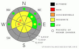
Danger Rose Tutorial
|
There is a level 2 or Moderate danger at upper elevations in the backcountry. Pockets of a higher level 3 danger probably exist on drifted slopes where somewhat unusual easterly winds are depositing fresh wind slabs this morning. Heightened avalanche conditions remain on isolated steep northerly facing slopes at upper elevations, and you might trigger very dangerous persistent slab avalanches on some slopes. Avoid rocky areas with shallower snow cover. Continue to evaluate the snow and terrain carefully, especially in drifted upper elevation terrain.... |
|
|
CURRENT CONDITIONS |

|
The Tony Grove Snotel at 8400' reports 4 new inches from yesterday containing 2/10ths of an inch of water. It's 18 degrees this morning and there is 31 inches of total snow on the ground.. It's 9 degrees at the 9700' CSI Logan Peak weather station, with a east-northeast wind this morning averaging a bit over 30 mph, with a gust of 50 mph already recorded this morning.... You'll find windy conditions and drifting snow in exposed terrain today |
|
|
RECENT ACTIVITY |

|
No new avalanches were reported recently in the Logan Area... |
|
|
THREAT #1 |

|
| WHERE |
PROBABILITY |
SIZE |
TREND |
|
|
|
|
| |
|
|
Over the next
12 hours.
|
|
|
Watch for developing and fresh wind slabs in exposed terrain, as strong easterly winds scour off the fresh and soft snow from east and northeast facing slopes and deposit it on the somewhat unusual west facing lee slopes. Expect to find fresh wind slabs in unusual or unexpected places... You might find sensitive wind slabs in deposition zones like the lee sides of ridges and sub-ridges, in gullies or scoops, near rock outcroppings, and under cliff bands... As usual, you should avoid smooth rounded, chalky looking or hollow sounding drifts on steep slopes... |
|
|
THREAT #2 |

|
| WHERE |
PROBABILITY |
SIZE |
TREND |
|
|
|
|
| |
|
|
Over the next
24 hours.
|
|
|
There are still slopes with suspect snow structure, and very dangerous persistent hard slabs could still be triggered on some steep north facing slopes at upper elevations. Be especially wary in rocky or shallow areas that held October snow before the big mid November storms. Hard slabs might be triggered from areas where they are thinner. The consequence of being caught in an early season avalanche is greatly increased by the shallowly buried and exposed rocks you could be raked over... |
|
|
GENERAL ANNOUNCEMENTS |
You have the opportunity to participate in the creation of our own community avalanche advisory by submitting avalanche and snow observations. You can also call us at 435-757-7578 or 801-524-5304 or email by clicking HERE
Donate to your favorite non-profit – The Friends of the Utah Avalanche Center. The UAC depends on contributions from users like you to support our work.
I will update this advisory by around 7:30 in the morning on Mondays, Wednesdays, Fridays, and Saturdays.....
This advisory is from the U.S.D.A. Forest Service, which is solely responsible for its content. This advisory describes general avalanche conditions and local variations always occur. |
|
|
This information does not apply to developed ski areas or highways where avalanche control is normally done. This advisory is from the U.S.D.A. Forest Service, which is solely responsible for its content. This advisory describes general avalanche conditions and local variations always occur. |
|
This advisory provided by the USDA Forest Service, in partnership with:
The Friends of the Utah Avalanche Center, Utah Division of State Parks and Recreation, Utah Division of Emergency Management, Salt Lake County, Salt Lake Unified Fire Authority and the friends of the La Sal Avalanche Center. See our Sponsors Page for a complete list. |
