SPECIAL ANNOUNCEMENT |
 |
Please join the Friends of the Utah Avalanche Center in Logan for our annual "Pray for Snow" Fundraiser and Party tonight at the Italian Place in downtown Logan. The event will feature a silent auction, raffle, great food, music, and a special presentation by Bruce Tremper, the Director of the Utah Avalanche Center.
Please call 757-2794 for more info. |
|
|
BOTTOM LINE
Danger by aspect and elevation on slopes approaching 35° or steeper.
(click HERE for tomorrow's danger rating)
|
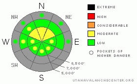
Danger Rose Tutorial
|
There is a level 2 or Moderate danger at upper elevations in the backcountry. Heightened avalanche conditions remain, and you might trigger very dangerous persistent slab avalanches on isolated steep northerly facing slopes at upper elevations. Avoid rocky areas with shallower snow cover. Fresh wind slabs are likely to develop in exposed terrain with increasing and shifting winds today and overnight. Continue to evaluate the snow and terrain carefully, especially in drifted upper elevation terrain.... |
|
|
CURRENT CONDITIONS |

|
You'll find soft, smooth, and fast recrystallized snow on shady slopes and either sun softened or crusty snow in more sunny areas. The best conditions are in lower angled sheltered terrain. Riders report rocky conditions in off road terrain, and you need to stay on roadways or smooth grassy upper elevation meadows to avoid damaging your sled... The snowpack is getting weaker and less supportable, so it's pretty easy to bog down and get stuck in sugary baseless snow if you get off the beaten track and lose momentum.
The Tony Grove Snotel at 8400' reports 33 degrees this morning and 28 inches of total snow on the ground.. It's 24 degrees at the 9700' CSI Logan Peak weather station, with a southwest wind this morning averaging around 20 mph. Overnight winds at the station averaged in the thirties for a couple hours overnight, with a gust of 42 mph reported early this morning. |
|
|
RECENT ACTIVITY |

|
No new avalanches were reported recently in the Logan Area... |
|
|
THREAT #1 |

|
| WHERE |
PROBABILITY |
SIZE |
TREND |

|
|
|
|
| |
|
|
Over the next
24 hours.
|
|
|
There are still slopes with suspect snow structure, and very dangerous persistent hard slabs could still be triggered on some steep north facing slopes at upper elevations. Be especially wary in rocky or shallow areas that held October snow before the big mid November storms. Hard slabs might be triggered from areas where they are thinner. The consequence of being caught in an early season avalanche is greatly increased by the shallowly buried and exposed rocks you could be raked over... |
|
|
THREAT #2 |

|
| WHERE |
PROBABILITY |
SIZE |
TREND |
|
|
|
|
| |
|
|
Over the next
24 hours.
|
|
|
Watch for developing and fresh wind slabs as winds increase today and shift from the northeast tonight... You might find sensitive wind slabs in deposition zones like the lee sides of ridges and sub-ridges, in gullies or scoops, near rock outcroppings, and under cliff bands... As usual, avoid smooth rounded, chalky looking or hollow sounding drifts on steep slopes... |
|
|
MOUNTAIN WEATHER |

|
Today's storm will bring more bluster than substance, and we'll be lucky to see more than a couple inches of accumulation in the mountains. Northwest winds will strengthen today and shift around from the northeast tonight. The winds will increase through the canyon mouths, impacting the northern Wasatch Front and prompting a High Wind Watch from the National Weather Service. Expect these winds in the mountains to average around 30 mph, with gusts of around 45 mph forecast... Another inch of accumulation is possible tonight. Another similar storm will swing through the region on Friday night, again only bringing an inch or two of much needed accumulation.... |
|
|
GENERAL ANNOUNCEMENTS |
You have the opportunity to participate in the creation of our own community avalanche advisory by submitting avalanche and snow observations. You can also call us at 435-757-7578 or 801-524-5304 or email by clicking HERE
Donate to your favorite non-profit – The Friends of the Utah Avalanche Center. The UAC depends on contributions from users like you to support our work.
I will update this advisory by around 7:30 in the morning on Mondays, Wednesdays, Fridays, and Saturdays.....
This advisory is from the U.S.D.A. Forest Service, which is solely responsible for its content. This advisory describes general avalanche conditions and local variations always occur. |
|
|
This information does not apply to developed ski areas or highways where avalanche control is normally done. This advisory is from the U.S.D.A. Forest Service, which is solely responsible for its content. This advisory describes general avalanche conditions and local variations always occur. |
|
This advisory provided by the USDA Forest Service, in partnership with:
The Friends of the Utah Avalanche Center, Utah Division of State Parks and Recreation, Utah Division of Emergency Management, Salt Lake County, Salt Lake Unified Fire Authority and the friends of the La Sal Avalanche Center. See our Sponsors Page for a complete list. |
