SPECIAL ANNOUNCEMENT |
 |
Please join the Friends of the Utah Avalanche Center in Logan for our annual "Pray for Snow" Fundraiser and Party on Wednesday November 30th at the Italian Place in downtown Logan. The event will feature a silent auction, raffle, great food, music, and a special presentation by Bruce Tremper, the Director of the Utah Avalanche Center.Please call 757-2794 for more info. |
|
|
BOTTOM LINE
Danger by aspect and elevation on slopes approaching 35° or steeper.
(click HERE for tomorrow's danger rating)
|
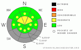
Danger Rose Tutorial
|
Despite shallow early season snow cover, heightened avalanche conditions still exist in the backcountry. You could trigger avalanches and there is a level 2 or Moderate danger on steep drifted slopes at upper elevations... The most significant danger remains on steep north facing slopes at upper elevations where very dangerous triggered persistent slab avalanches are still possible. Triggered wind slabs and loose wet avalanches are also possible in steep terrain... Evaluate the snow and terrain carefully, especially in drifted northerly facing upper elevation terrain.... |
|
|
CURRENT CONDITIONS |

|
We found nice riding conditions over the weekend in graupel and a few inches of drifted but fairly smooth fresh snow.... Riders report rocky conditions in off road terrain, and you need to stay on roadways or smooth grassy upper elevation meadows to avoid damaging your sled... The snowpack is getting weaker and less supportable, so it's pretty easy to bog down and get stuck in sugary baseless snow if you get off the beaten track and lose momentum.
The Tony Grove Snotel at 8400' reports a balmy 39 degrees this morning and 29 inches of total snow on the ground.. It's 32 degrees at the 9700' CSI Logan Peak weather station, with a west wind this morning averaging around 20 mph. Overnight winds at the station averaged in the thirties for a couple hours overnight, with a gust of 46 mph reported early this morning. |
|
|
RECENT ACTIVITY |

|
No new avalanches were reported recently in the Logan Area...
|
|
|
THREAT #1 |

|
| WHERE |
PROBABILITY |
SIZE |
TREND |
|
|
|
|
| |
|
|
Over the next
24 hours.
|
|
|
With significant sublimation occurring over the past several days, the snowpack continues to weaken and the tension in the slabs appears to be relaxing. Even so, there are slopes with suspect snow structure, and persistent hard slabs could still be triggered on some steep north facing slopes at upper elevations. Be especially wary in rocky or shallow areas that held October snow before the big mid November storms. The consequence of being caught in an early season hard slab avalanche is greatly increased by the shallowly buried and exposed rocks you could be raked over... |
|
|
THREAT #2 |

|
| WHERE |
PROBABILITY |
SIZE |
TREND |

|
|
|
|
| |
|
|
Over the next
24 hours.
|
|
|
With fairly strong west winds overnight and in the past several days, you'll likely find drifts and stiff stubborn wind slabs in deposition zones like the lee sides of ridges and sub-ridges, in gullies or scoops, near rock outcroppings, and under cliff bands... Avoid smooth rounded or chalky looking or hollow sounding drifts on steep slopes... |
|
|
THREAT #3 |

|
| WHERE |
PROBABILITY |
SIZE |
TREND |
|
|
|
|
| |
|
|
Over the next
10 hours.
|
|
|
Warm temperatures at upper elevations have created the possibility of loose wet avalanches on steep slopes with saturated surface snow. If the snow you're on is saturated and soft, you might trigger small wet avalanches on steep slopes... Make sure no one is below you, and move to lower angled or shady terrain.... |
|
|
MOUNTAIN WEATHER |

|
Thin high clouds will thicken up today as a mostly dry and weak cold front moves over the area... Don't expect much in the way of accumulation, but we could see a snowflake or two from this system and mountain temperatures should cool down. The high pressure system will rebuild on Tuesday.. The next somewhat more energetic front will affect our area on Wednesday and Wednesday night, and we could pick up a few inches of snow.... East or down canyon winds may become an issue after the frontal passage... Forecasters are unsure of next weekend's weather outlook, as there is a fair amount of difference of opinion between the models.... |
|
|
GENERAL ANNOUNCEMENTS |
You have the opportunity to participate in the creation of our own community avalanche advisory by submitting avalanche and snow observations. You can also call us at 435-757-7578 or 801-524-5304 or email by clicking HERE
Donate to your favorite non-profit – The Friends of the Utah Avalanche Center. The UAC depends on contributions from users like you to support our work.
I will update this advisory by around 7:30 in the morning on Mondays, Wednesdays, Fridays, and Saturdays.....
This advisory is from the U.S.D.A. Forest Service, which is solely responsible for its content. This advisory describes general avalanche conditions and local variations always occur. |
|
|
This information does not apply to developed ski areas or highways where avalanche control is normally done. This advisory is from the U.S.D.A. Forest Service, which is solely responsible for its content. This advisory describes general avalanche conditions and local variations always occur. |
|
This advisory provided by the USDA Forest Service, in partnership with:
The Friends of the Utah Avalanche Center, Utah Division of State Parks and Recreation, Utah Division of Emergency Management, Salt Lake County, Salt Lake Unified Fire Authority and the friends of the La Sal Avalanche Center. See our Sponsors Page for a complete list. |
