SPECIAL ANNOUNCEMENT |
 |
Please join the Friends of the Utah Avalanche Center in Logan for our annual "Pray for Snow" Fundraiser and Party on Wednesday November 30th at the Italian Place in downtown Logan. The event will feature a silent auction, raffle, great food, music, and a special presentation by Bruce Tremper, the Director of the Utah Avalanche Center.Please call 757-2794 for more info. |
|
|
BOTTOM LINE
Danger by aspect and elevation on slopes approaching 35° or steeper.
(click HERE for tomorrow's danger rating)
|
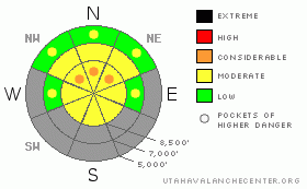
Danger Rose Tutorial
|
Despite shallow early season snow cover, heightened avalanche conditions exist in the backcountry. You could trigger avalanches and there is a level 2 or Moderate danger on steep drifted slopes.. Pockets with a higher level 3 danger remain on steep north facing slopes at upper elevations where very dangerous triggered persistent slab avalanches are still quite possible. The consequence of being caught in an early season avalanche is greatly increased by the shallowly buried and exposed rocks you could be raked over... You'll find safer conditions in sheltered terrain at lower elevations, on slopes without weak early season base layers, and on lower angled slopes. Evaluate the snow and terrain carefully, especially in drifted upper elevation and rocky terrain.... |
|
|
CURRENT CONDITIONS |

|
Don't expect a powder day in the mountains today because strong gusty winds and periods of sun and warmth have done a number on the snow surface... Last nights drop in temperature must have solidified the saturated surface at lower and mid elevations, and you'll find a wide variety of wind effects in most other areas. Yesterday's winds really got down into the terrain, scouring and drifting snow even in normally sheltered and lower elevation areas...
The Tony Grove Snotel at 8400' reports 13 degrees this morning. There's 2 new inches of snow containing 3/10ths of an inch of water and 32 inches of total snow on the ground.. It's 9 degrees at the 9700' CSI Logan Peak weather station, with northwest wind this morning averaging around 15mph. |
|
|
RECENT ACTIVITY |

|
There is some question as to the trigger of a good sized hard slab avalanche just outside the boundary of the Brighten Ski Area yesterday... The two-foot-deep avalanche ran on a layer of sugary facets near the ground...... No new avalanches were reported recently in the Logan Area...
The strong high pressure on our doorstep will do nothing but bad to our shallow, already weak early season snowpack. Unfortunately, widespread development of sugary persistent weak layers is a likely outcome. |
|
|
THREAT #1 |

|
| WHERE |
PROBABILITY |
SIZE |
TREND |
|
|
|
|
| |
|
|
Over the next
24 hours.
|
|
|
My snowpit tests this week consistently showed poor snow structure and full propagation failures on north facing slopes above around 8500' in elevation in the Tony Grove Area.... Most suspect upper elevation slopes in the Logan Area remain untracked and untested, and I certainly don't want to try my luck by getting out on them...
Upper elevation shady slopes held several inches of October snow that became hardened by the melt-freeze process... A few inches of light snow fell at the end of October and the beginning of November and cold temperatures subjected this light density layer to an extreme temperature gradient, causing the development of faceted or sugary snow and a persistent weak layer... Avalanches failing on this layer could now be 2 or 3 feet deep and pack a dangerous punch.. |
|
|
THREAT #2 |

|
| WHERE |
PROBABILITY |
SIZE |
TREND |
|
|
|
|
| |
|
|
Over the next
24 hours.
|
|
|
After sustained southwest wind and substantial drifting yesterday and in the past couple days, you'll find drifts and stiff wind slabs in deposition zones like the lee sides of ridges and sub-ridges, in gullies or scoops, near rock outcroppings, and under cliff bands... Avoid smooth rounded or chalky looking or hollow sounding drifts on steep slopes... In some steep upper elevation terrain a wind slab avalanche overrunning a slope with poor snow structure could produce a much more dangerous and deeper avalanche... |
|
|
MOUNTAIN WEATHER |

|
It'll be mostly sunny today in the mountains, with a light northwest wind and forecast temperatures climbing to around 31 degrees. A strong ridge of high pressure will set up over the area for the weekend. A brush-by storm is expected to bring a little more snow to the mountains of far northern Utah late Monday, but high pressure will control the weather pattern well into next week and potentially beyond..... |
|
|
GENERAL ANNOUNCEMENTS |
You have the opportunity to participate in the creation of our own community avalanche advisory by submitting avalanche and snow observations. You can also call us at 435-757-7578 or 801-524-5304 or email by clicking HERE
Donate to your favorite non-profit – The Friends of the Utah Avalanche Center. The UAC depends on contributions from users like you to support our work.
I will update this advisory by around 7:30 in the morning on Mondays, Wednesdays, Fridays, and Saturdays.....
This advisory is from the U.S.D.A. Forest Service, which is solely responsible for its content. This advisory describes general avalanche conditions and local variations always occur. |
|
|
This information does not apply to developed ski areas or highways where avalanche control is normally done. This advisory is from the U.S.D.A. Forest Service, which is solely responsible for its content. This advisory describes general avalanche conditions and local variations always occur. |
|
This advisory provided by the USDA Forest Service, in partnership with:
The Friends of the Utah Avalanche Center, Utah Division of State Parks and Recreation, Utah Division of Emergency Management, Salt Lake County, Salt Lake Unified Fire Authority and the friends of the La Sal Avalanche Center. See our Sponsors Page for a complete list. |
