SPECIAL ANNOUNCEMENT |
 |
Please join the Friends of the Utah Avalanche Center in Logan for our annual "Pray for Snow" Fundraiser and Party on Wednesday November 30th at the Italian Place in downtown Logan. The event will feature a silent auction, raffle, great food, music, and a special presentation by Bruce Tremper, the Director of the Utah Avalanche Center.Please call 757-2794 for more info. |
|
|
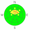
BOTTOM LINE
Danger by aspect and elevation on slopes approaching 35° or steeper.
(click HERE for tomorrow's danger rating)
|

Danger Rose Tutorial
|
Heightened avalanche conditions exist in the backcountry, and there is a level 2 or Moderate danger on drifted upper elevation and wind exposed slopes.. There are also pockets with a higher level 3 danger on steep north facing slopes at upper elevations where dangerous triggered persistent slab avalanches are still probable. The danger of going for a ride in an avalanche in the early season is greatly increased by the shallowly buried and exposed rocks you could be swept over or into. Evaluate the snow and terrain carefully, especially in upper elevation rocky terrain.... |
|
|
CURRENT CONDITIONS |

|
You can find pretty good powder riding conditions if you stick to upper elevation roadways and smooth meadows. The unconsolidated snowpack above 8000' in elevation ranges from a bit under 3' to around 4 feet deep.. The snow berm, which prevents driving, is now in place at the bottom of Tony Grove Road, and with the exception of the bottom mile, the road is in fine smooth shape for riding...
The Tony Grove Snotel at 8400' reports 31 degrees this morning with 33 inches of total snow on the ground.. We noted about 3 inches of fresh drifted snow in the area yesterday. It's only 11 degrees at the Hwy 89 Summit weather station with a light east-northeast wind this morning. Southwest winds picked up yesterday, drifting a fair amount of snow in exposed terrain. |
|
|
RECENT ACTIVITY |

|
We saw evidence of some fresh but somewhat minor wind slab and cornice fall avalanching off the Chicken Hill ridgeline yesterday.... No triggered or other avalanches have been reported recently in the Logan Area... |
|
|
THREAT #1 |

|
| WHERE |
PROBABILITY |
SIZE |
TREND |
|
|
|
|
| |
|
|
Over the next
24 hours.
|
|
|
Upper elevation shady slopes held several inches of October snow that became hardened by the melt-freeze process... A few inches of light snow fell at the end of October and the beginning of November and cold temperatures subjected this light density layer to an extreme temperature gradient, causing the development of faceted or sugary snow and a persistent weak layer... Avalanches failing on this layer could now be 2 to 4 feet deep and pack a dangerous punch, but they are only likely in the highest north facing steep rocky terrain.. |
|
|
THREAT #2 |

|
| WHERE |
PROBABILITY |
SIZE |
TREND |

|
|
|
|
| |
|
|
Over the next
24
hours.
|
|
|
After sustained southwest wind and verified substantial drifting yesterday, you'll likely find stiff fresh wind slabs in deposition zones like the lee sides of ridges and sub-ridges, in gullies or scoops, near rock outcroppings, and under cliff bands... Avoid smooth rounded or chalky looking or hollow sounding drifts on steep slopes... In some steep upper elevation terrain a wind slab avalanche overrunning a slope with poor snow structure could produce a much more dangerous and deeper avalanche... |
|
|
MOUNTAIN WEATHER |

|
It will be mostly sunny in the mountains today, with a continuing southwesterly breeze and a forecast high temperature of around 41 degrees. Temperatures will remain colder at lower elevation due to a substantial temperature inversion. Southwest winds will increase again overnight, and we'll see increasing clouds on Thanksgiving Day with continued southwest winds and a twenty percent chance of some snow... Snowfall from a fast moving cold front should begin late Thursday night and continue into Friday, with 3 to 5 inches of accumulation forecast... The high pressure system will redevelop over the weekend and likely last well into next week.... |
|
|
GENERAL ANNOUNCEMENTS |
You have the opportunity to participate in the creation of our own community avalanche advisory by submitting avalanche and snow observations. You can also call us at 435-757-7578 or 801-524-5304 or email by clicking HERE
Donate to your favorite non-profit – The Friends of the Utah Avalanche Center. The UAC depends on contributions from users like you to support our work.
I will update this advisory by around 7:30 in the morning on Mondays, Wednesdays, Fridays, and Saturdays.....
This advisory is from the U.S.D.A. Forest Service, which is solely responsible for its content. This advisory describes general avalanche conditions and local variations always occur. |
|
|
This information does not apply to developed ski areas or highways where avalanche control is normally done. This advisory is from the U.S.D.A. Forest Service, which is solely responsible for its content. This advisory describes general avalanche conditions and local variations always occur. |
|
This advisory provided by the USDA Forest Service, in partnership with:
The Friends of the Utah Avalanche Center, Utah Division of State Parks and Recreation, Utah Division of Emergency Management, Salt Lake County, Salt Lake Unified Fire Authority and the friends of the La Sal Avalanche Center. See our Sponsors Page for a complete list. |
