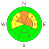
BOTTOM LINE
Danger by aspect and elevation on slopes approaching 35° or steeper.
(click HERE for tomorrow's danger rating)
|
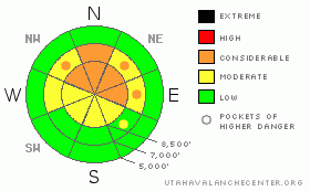
Danger Rose Tutorial
|
There is a level 3 or Considerable danger, and dangerous triggered persistent slab avalanches are still probable on northerly facing slopes at upper elevations. A level 2 danger and heightened avalanche conditions can be found on many other upper and mid elevation slopes, with triggered wind slabs and persistent slabs possible on steep drifted slopes...The danger of going for a ride in an avalanche is magnified by the shallowly buried and exposed rocks you could be swept over. Careful snowpack evaluation, cautious route finding, and conservative decision making will be crucial in the backcountry today, especially at upper elevations.... |
|
|
CURRENT CONDITIONS |

|
The Tony Grove Snotel at 8400' reports 22 degrees this morning with 34 inches of total snow on the ground... It's 19 degrees at the 9700' CSI Logan Peak weather station with a light south wind overnight and this morning.
Remember that the Tony Grove Road is not maintained for wheeled vehicles in the winter....The upper section of the road is certainly not drivable after Friday's productive storm... In the early season, snowmobiles, 4x4s, and pedestrians will all have to share the road, so keep your speed down and be respectful of other users....
|
|
|
RECENT ACTIVITY |

|
No avalanches have been reported locally since we observed evidence of a large natural avalanche last Monday in the Tony Grove-Blind Hollow saddle. The persistent slab avalanche was around 100 feet wide and at least 2 feet deep... |
|
|
THREAT #1 |

|
| WHERE |
PROBABILITY |
SIZE |
TREND |
|
|
|
|
| |
|
|
Over the next
24 hours.
|
|
|
Last weekend's storm built a significant slab on weak faceted or sugary preexisting snow. Friday's storm likely added enough weight to reactivate the weak faceted layer which sits at the interface between solidly refrozen October snow and colder dense snow from early November and last weekend... Pay attention to obvious signs of instability like collapsing and cracking, and avoid and stay out from under steep drifted slopes... Avalanches could be triggered remotely from a distance or worse, from below..... |
|
|
THREAT #2 |

|
| WHERE |
PROBABILITY |
SIZE |
TREND |
|
|
|
|
| |
|
|
Over the next
24
hours.
|
|
|
You might find soft wind slabs in deposition zones like the lee sides of ridges and sub-ridges, in gullies or scoops, near rock outcroppings, and under cliff bands... Avoid smooth rounded or chalky looking or hollow sounding drifts on steep slopes... |
|
|
MOUNTAIN WEATHER |

|
It will be cloudy in the mountains today, with a southwesterly breeze and a bit more snow possible. . A couple more ripples will cross the region in the next couple days, and an inch or two of additional snow may accumulate. Expect similar weather tomorrow... A high pressure system will set up over the area for the middle of the week and the next sizable storm will impact the region on around Thanksgiving Day night.... |
|
|
GENERAL ANNOUNCEMENTS |
Please join the Friends of the Utah Avalanche Center in Logan for our annual "Pray for Snow" Fundraiser and Party on Wednesday November 30th at the Italian Place in downtown Logan. The event will feature a silent auction, raffle, great food, music, and a special presentation by Bruce Tremper, the Director of the Utah Avalanche Center.Please call 757-2794 for more info.
You have the opportunity to participate in the creation of our own community avalanche advisory by submitting avalanche and snow observations. You can also call us at 435-757-7578 or 801-524-5304 or email by clicking HERE
Donate to your favorite non-profit – The Friends of the Utah Avalanche Center. The UAC depends on contributions from users like you to support our work.
I will update this advisory by around 7:30 in the morning on Mondays, Wednesdays, Fridays, and Saturdays.....
This advisory is from the U.S.D.A. Forest Service, which is solely responsible for its content. This advisory describes general avalanche conditions and local variations always occur. |
|
|
This information does not apply to developed ski areas or highways where avalanche control is normally done. This advisory is from the U.S.D.A. Forest Service, which is solely responsible for its content. This advisory describes general avalanche conditions and local variations always occur. |
|
This advisory provided by the USDA Forest Service, in partnership with:
The Friends of the Utah Avalanche Center, Utah Division of State Parks and Recreation, Utah Division of Emergency Management, Salt Lake County, Salt Lake Unified Fire Authority and the friends of the La Sal Avalanche Center. See our Sponsors Page for a complete list. |
