AVALANCHE WATCH »
The risk of an avalanche is expected to increase significantly
but the timing and location are still uncertain. Stay tuned for updates.
|
 |
Notice: We've issued an avalanche watch for increased avalanche danger on Saturday and Sunday because of an expected foot of new snow with strong winds tonight..... |
|
|
BOTTOM LINE
Danger by aspect and elevation on slopes approaching 35° or steeper.
(click HERE for tomorrow's danger rating)
|
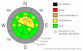
Danger Rose Tutorial
|
Expect a rising danger as we head into the weekend, with snow and wind forecast for today... You'll find heightened avalanche conditions and a level 2 or Moderate danger on many mid and upper elevation slopes in the backcountry today, and you could trigger dangerous avalanches on steep drifted slopes. A few pockets with a level 3 or Considerable danger remain on slopes with weak snow preexisting before last weekend's storm... The danger of going for a ride in an avalanche is magnified by the shallowly buried and exposed rocks you could be swept over. The danger will rise further with snowfall continuing overnight, and dangerous avalanche conditions will likely become more widespread tomorrow. Evaluate the snow and terrain carefully , especially if you venture into the higher elevations.... |
|
|
CURRENT CONDITIONS |

|
The Tony Grove Snotel at 8400' reports a balmy 28 degrees this morning with 19 inches of total snow on the ground... The Hwy 89 Logan Summit weather station reports a sustained west northwest wind from overnight with gusts in the mid 20 mph range. Accumulating snowfall is visible on the weather camera this morning... Very shallow snow conditions exist at mid and lower elevations and upper elevation slopes, with better snow cover, also contain pockets with dangerous avalanche conditions...
Remember that the Tony Grove Road is not maintained for wheeled vehicles in the winter....The road is currently snow and ice covered, with around 2 feet of new snow up high from last weekend's storm. In the early season, snowmobiles, 4x4s, and pedestrians will all have to share the road, so keep your speed down and be respectful of other users.... |
|
|
RECENT ACTIVITY |

|
Locally, we've still been triggering large audible collapses on shady slopes at upper elevations this week, but the snowpack is gradually strengthening since last weekend's storm. We observed evidence of a large natural avalanche on Monday in the Tony Grove-Blind Hollow saddle. The persistent slab avalanche was around 100 feet wide and at least 2 feet deep... |
|
|
THREAT #1 |

|
| WHERE |
PROBABILITY |
SIZE |
TREND |
|
|
|
|
| |
|
|
Over the next
24 hours.
|
|
|
Last weekend's storm built a significant slab on weak faceted or sugary preexisting snow. Areas with dangerous avalanche conditions linger on some steep slopes that were snow covered before last weekend's storm, mostly on northerly facing slopes above around 8000' in elevation. Today's storm will add to the weight of the slab and dangerous conditions are likely to become more widespread for the coming weekend. Pay attention to obvious signs of instability like collapsing and cracking and avoid and stay out from under steep drifted slopes... Avalanches still could be triggered remotely from a distance or worse, from below..... |
|
|
THREAT #2 |

|
| WHERE |
PROBABILITY |
SIZE |
TREND |
|
|
|
|
| |
|
|
Over the next
24 hours.
|
|
|
Depending on how much snow falls today, strong and gusty west winds will form fresh drifts and wind slabs in exposed terrain.... Wind slabs will be found on the lee sides of ridges, in scoops, near cliff bands, and in gullies... Avoid smooth rounded or chalky looking drifts on steep slopes, and be wary of areas with wind stiffened or deposited surface snow. |
|
|
MOUNTAIN WEATHER |

|
It is snowing this morning, and it looks like it will be a rather stormy day in the mountains. The National Weather Service has issued a Winter Weather Advisory due to an approaching storm that will impact our area today and overnight... Mountain temperatures will rise to around freezing (32 degrees) by around noon, and then begin to fall back into the twenties. Expect fairly strong west winds this morning with ridgetop windspeeds sustaining 40 mph and gusting up to around 60 mph. Winds will diminish into the upper teens by evening.... The bulk of the snow will fall overnight, with 3 to 5 inches of accumulation forecast during the day today, and another 8 to12 forecast for tonight. Snowfall should end on Saturday, but may redevelop for a while on Sunday.... |
|
|
GENERAL ANNOUNCEMENTS |
Please join the Friends of the Utah Avalanche Center in Logan for our annual "Pray for Snow" Fundraiser and Party on Wednesday November 30th at the Italian Place in downtown Logan. The event will feature a silent auction, raffle, great food, music, and a special presentation by Bruce Tremper, the Director of the Utah Avalanche Center.Please call 757-2794 for more info.
You have the opportunity to participate in the creation of our own community avalanche advisory by submitting avalanche and snow observations. You can also call us at 435-757-7578 or 801-524-5304 or email by clicking HERE
Donate to your favorite non-profit – The Friends of the Utah Avalanche Center. The UAC depends on contributions from users like you to support our work.
I will update this advisory by around 7:30 in the morning on Mondays, Wednesdays, Fridays, and Saturdays.....
This advisory is from the U.S.D.A. Forest Service, which is solely responsible for its content. This advisory describes general avalanche conditions and local variations always occur. |
|
|
This information does not apply to developed ski areas or highways where avalanche control is normally done. This advisory is from the U.S.D.A. Forest Service, which is solely responsible for its content. This advisory describes general avalanche conditions and local variations always occur. |
|
This advisory provided by the USDA Forest Service, in partnership with:
The Friends of the Utah Avalanche Center, Utah Division of State Parks and Recreation, Utah Division of Emergency Management, Salt Lake County, Salt Lake Unified Fire Authority and the friends of the La Sal Avalanche Center. See our Sponsors Page for a complete list. |
