BOTTOM LINE
Danger by aspect and elevation on slopes approaching 35° or steeper.
(click HERE for tomorrow's danger rating)
|
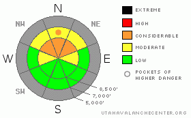
Danger Rose Tutorial
|
Heavy snowfall and strong winds will cause the danger to rapidly rise through level 2 or Moderate this morning. The danger will rise to level 3, Considerable during the day today in steep terrain with preexisting snow. Dangerous avalanche conditions will develop at upper elevations, mainly on north facing slopes, and human triggered avalanches will become likely today... Careful snowpack evaluation, cautious route finding, and conservative decision making will be crucial in the backcountry today....
|
|
|
CURRENT CONDITIONS |

|
You'll find a base consisting of very shallow yet mostly solid October snow only on north facing slopes above around 8500'. Several inches of soft or wind drifted snow from last weekend make for decent and fast riding conditions on smooth grassy slopes, but coverage is still quite thin and you should expect to also find rocks in most areas.
Remember that the Tony Grove Road is not maintained for wheeled vehicles in the winter. The road is currently covered by snow and ice in places, and driving conditions are likely to rapidly deteriorate in today's storm.... |
|
|
RECENT ACTIVITY |

|
A couple small avalanches were reported over the last week in the Central Wasatch Range, and we've got similar snow structure at upper elevations around Logan... Yesterday in the Tony Grove Area, we were easily able to trigger cracking and collapses on faceted or sugary snow which sits atop the now solid snow from early October and below wind drifted snow from last weekend and Monday.... |
|
|
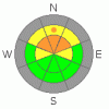
THREAT #1 |

|
| WHERE |
PROBABILITY |
SIZE |
TREND |
|
|
|
|
| |
|
|
Over the next
24 hours.
|
|
|
Heavy snowfall and strong wind will create dangerous avalanche conditions at upper elevations today. Rapidly accumulating snow will not bond well to the old snow surface on many slopes with preexisting snow. Human triggered avalanches will become probable as significant snow piles up on steep slopes during the day today... |
|
|
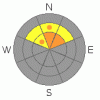
THREAT #2 |

|
| WHERE |
PROBABILITY |
SIZE |
TREND |
|
|
|
|
| |
|
|
Over the next
24 hours.
|
|
|
In the Logan Area, wind slabs formed over the past week on very weak sugary or faceted snow just above the solid early October base. These present the most danger on drifted north facing slopes at upper elevations. Heavy snowfall and strong winds forecast for the weekend will cause a drastic rise in danger on slopes with preexisting snow, especially where this weak snow structure persists... |
|
|
MOUNTAIN WEATHER |

|
The National Weather Service has upgraded today's storm, and they have issued a Winter Storm Warning for the mountains of Northern Utah north of I-80... Forecasters are now calling for 15 to 21 inches of accumulation today on favored upper elevation slopes accompanied by strong southerly winds sustaining 35-45 mph ridgetop windspeeds with gusts of around 60 mph possible.... We should get a short break tonight, but more storminess is expected tomorrow with strong west winds and an additional 6 to 10 inches of accumulation forecast.... It looks like a moist northwest flow will keep a chance of snow in the forecast through much of the coming week.... |
|
|
GENERAL ANNOUNCEMENTS |
Please join the Friends of the Utah Avalanche Center in Logan for our annual "Pray for Snow" Fundraiser and Party on Wednesday November 30th at the Italian Place in downtown Logan. The event will feature a silent auction, raffle, great food, music, and a special presentation by Bruce Tremper, the Director of the Utah Avalanche Center.
Please call 757-2794 for more info. |
|
|
This information does not apply to developed ski areas or highways where avalanche control is normally done. This advisory is from the U.S.D.A. Forest Service, which is solely responsible for its content. This advisory describes general avalanche conditions and local variations always occur. |
|
This advisory provided by the USDA Forest Service, in partnership with:
The Friends of the Utah Avalanche Center, Utah Division of State Parks and Recreation, Utah Division of Emergency Management, Salt Lake County, Salt Lake Unified Fire Authority and the friends of the La Sal Avalanche Center. See our Sponsors Page for a complete list. |
