SPECIAL ANNOUNCEMENT |
 |
Please join the Friends of the Utah Avalanche Center in Logan for our annual "Pray for Snow" Fundraiser and Party on Wednesday November 30th at the Italian Place in downtown Logan. The event will feature a silent auction, raffle, great food, music, and a special presentation by Bruce Tremper, the Director of the Utah Avalanche Center.
Please call 757-2794 for more info. |
|
|
BOTTOM LINE
Danger by aspect and elevation on slopes approaching 35° or steeper.
(click HERE for tomorrow's danger rating)
|
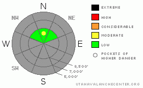
Danger Rose Tutorial
|
The danger is mostly Low or level 1. A few pockets with Moderate or level 2 danger exist in areas with preexisting snow, and you might trigger shallow persistent slabs at the highest elevations on a few steep drifted north facing slopes. Heavy snowfall and strong winds will create a rising danger in the backcountry tomorrow and through the weekend, especially on slopes with preexisting snow.
|
|
|
CURRENT CONDITIONS |

|
You'll find a base consisting of very shallow yet mostly solid October snow only on north facing slopes above around 8500'. Several inches of soft or wind drifted snow from last weekend make for decent and fast riding conditions on smooth grassy slopes, but coverage is still quite thin and you should expect to also find rocks in most areas.
Remember that the Tony Grove Road is not maintained for wheeled vehicles in the winter. The road is currently covered by snow and ice in places, and driving conditions are likely to rapidly deteriorate in the coming storm.... |
|
|
RECENT ACTIVITY |

|
A couple small avalanches were reported over the last week in the Central Wasatch Range, and we've got similar snow structure at upper elevations around Logan... Yesterday in the Tony Grove Area, we were easily able to trigger cracking and collapses on faceted or sugary snow which sits atop the now solid snow from early October and below wind drifted snow from last weekend and Monday.... |
|
|
THREAT #1 |

|
| WHERE |
PROBABILITY |
SIZE |
TREND |

|
|
|
|
| |
|
|
Over the next
24 hours.
|
|
|
In the Logan Area, wind slabs formed over the past week on very weak sugary or faceted snow just above the solid early October base. These present some danger on a few isolated drifted north facing slopes at upper elevations. Heavy snowfall and strong winds forecast for the weekend will cause a drastic rise in danger on slopes with preexisting snow where this weak snow structure persists... |
|
|
MOUNTAIN WEATHER |

|
It will be mostly sunny , warm, and breezy in the mountains today. High cloud cover and winds will increase this afternoon as a strong Pacific storm approaches our area from the northwest. Pre-frontal snow may begin falling late tonight in the mountains and an inch or two could accumulate. Expect the cold front to push through our area early tomorrow, with snowfall and winds increasing after its passage. Snow levels will drop throughout the morning, with some snow expected in the valley floors by Saturday afternoon. Snowfall will tapper off in the evening, but the break will be brief as a trailing cold front will reestablish snowfall tomorrow night. A moist northwest flow will continue to bring unsettled weather and some more periods of snow to the mountains of far northern Utah through the first half of next week..... |
|
|
GENERAL ANNOUNCEMENTS |
We're back in the office and we'll start issuing regular advisories when more snow falls in the mountains around Logan....... |
|
|
This information does not apply to developed ski areas or highways where avalanche control is normally done. This advisory is from the U.S.D.A. Forest Service, which is solely responsible for its content. This advisory describes general avalanche conditions and local variations always occur. |
|
This advisory provided by the USDA Forest Service, in partnership with:
The Friends of the Utah Avalanche Center, Utah Division of State Parks and Recreation, Utah Division of Emergency Management, Salt Lake County, Salt Lake Unified Fire Authority and the friends of the La Sal Avalanche Center. See our Sponsors Page for a complete list. |
