SPECIAL ANNOUNCEMENT |
 |
Please join the Friends of the Utah Avalanche Center in Logan for our annual "Pray for Snow" Fundraiser and Party on Wednesday November 30th at the Italian Place in downtown Logan. The event will feature a silent auction, raffle, great food, music, and a special presentation by Bruce Tremper, the Director of the Utah Avalanche Center.
Please call 757-2794 for more info. |
|
|
BOTTOM LINE
Danger by aspect and elevation on slopes approaching 35° or steeper.
(click HERE for tomorrow's danger rating)
|
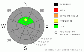
Danger Rose Tutorial
|
Pockets with Moderate or level 2 danger exist in areas with preexisting snow and you could trigger shallow wind slabs at the highest elevations on a few steep drifted north facing slopes. Carry your rescue gear and follow normal winter safe travel protocols..... |
|
|
CURRENT CONDITIONS |

|
Under several inches of fresh snow from the weekend you'll find very shallow yet mostly solid October snow only on north facing slopes above around 8500', but coverage is quite thin and you should expect to also find rocks.
Remember that the Tony Grove Road is not maintained for wheeled vehicles in the winter, and driving conditions are likely to rapidly deteriorate in a storm.... |
|
|
RECENT ACTIVITY |

|
Last week we triggered surface cracking and a couple very small and manageable wind slabs in steep terrain.... A skier triggered a small wind slab yesterday in Little Cottonwood Canyon in the Central Wasatch.
|
|
|
THREAT #1 |

|
| WHERE |
PROBABILITY |
SIZE |
TREND |

|
|
|
|
| |
|
|
Over the next
24 hours.
|
|
|
In the Logan Area, slabs forming on weak sugary or faceted snow just above the solid October base may present some danger. Shallow wind slabs likely formed over the weekend on isolated steep north facing slopes at upper elevations. On some smooth slopes with previous snow cover you might trigger small generally manageable wind slab avalanches. While it is unlikely that you will be buried, these may present a problem in some steep rocky or treed terrain.... |
|
|
MOUNTAIN WEATHER |

|
Light snowfall today will only deliver a little more snow to the mountains. More light snowfall is possible tomorrow before a short lived high pressure system moves over the area for Wednesday and Thursday. This won't persist for long and more storminess is possible for the coming weekend under a progressive system, but a splitting trend could send the bulk of the action to the south once again... |
|
|
GENERAL ANNOUNCEMENTS |
We're back in the office and we'll start issuing regular advisories when more snow falls in the mountains around Logan....... |
|
|
This information does not apply to developed ski areas or highways where avalanche control is normally done. This advisory is from the U.S.D.A. Forest Service, which is solely responsible for its content. This advisory describes general avalanche conditions and local variations always occur. |
|
This advisory provided by the USDA Forest Service, in partnership with:
The Friends of the Utah Avalanche Center, Utah Division of State Parks and Recreation, Utah Division of Emergency Management, Salt Lake County, Salt Lake Unified Fire Authority and the friends of the La Sal Avalanche Center. See our Sponsors Page for a complete list. |
