SPECIAL ANNOUNCEMENT |
 |
Through a generous donation by Backcountry.com to our partners the Friends of the Utah Avalanche Center we will continue forecasting through the Easter weekend. Today is the last advisory for the season, but with significantly more than normal snow in the mountains this spring, avalanche threats will likely linger for a while.... |
|
|
BOTTOM LINE
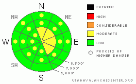
Danger by aspect and elevation on slopes approaching 35° or steeper.
(click HERE for tomorrow's danger rating)
|

Danger Rose Tutorial
|
This beautiful Easter morning there's a Level 1 or Low danger, and mostly stable snow conditions exist on the majority of slopes in the backcountry. There are also some areas with a Level 2 or Moderate danger, and you'll find heightened conditions in drifted terrain with recent deposits of fresh snow. Triggered shallow wind slab avalanches and large cornice falls are possible at upper elevations. Seasonal midday warming may cause a Level 2 danger, and heightened conditions could develop on steep slopes at any elevation with saturated snow that become softened by seasonal midday warmth... Use normal caution, continue to follow safe travel protocols, and evaluate the snow and terrain carefully. |
|
|
CURRENT CONDITIONS |

|
. Happy Easter....You might need crampons and an ice axe for some early morning mountain ascents after another pretty good refreeze overnight. Folks found nice shallow and smooth powder riding conditions at upper elevations in the Central Bear River Range yesterday. At lower elevations and in most other areas, the snow is supportable and well refrozen in the morning, and the surface is nicely softening up with daytime warming. The 8400' Tony Grove Snotel reports 24 degrees this morning and an inch of new snow overnight. There's 139 inches of total snow at the station, with 173% of average water content for the date.. |
|
|
RECENT ACTIVITY |

|
We've had reports of several more unintentionally triggered avalanches in the Central Wasatch Range on Friday. There were a number of close calls during the week week, with a couple people reportedly caught and carried by wind slab avalanches that they triggered, and at least one injury..
Locally; an observer reports seeing evidence of several shallow rider triggered wind slabs from yesterday and Friday and a few natural wind slab avalanches from the Thursday storm in the Central Bear River Range. The fresh wind slabs involving drifted snow from 4/21were less than a foot deep (4 to 8 inches) and did not run all that far... Several large glide cracks have appeared across the zone with last week's warm temperatures...
.See our avalanche list HERE
|
|
|
THREAT #1 |

|
| WHERE |
PROBABILITY |
SIZE |
TREND |

|
|
|
|
| |
|
|
Over the next
24 hours.
|
|
|
After another cold night in the mountains, avalanches are generally unlikely and the snow is stable on most slopes this morning... Exceptions can be found on steep slopes with warmth softened saturated snow, and in some upper elevation areas with recent deposits of drifted snow.
Continue to avoid the large overhanging ridge-top cornices, which again built up late last week, with sustained west winds and moist fresh snow. These large cornices will become more dangerous in midday warmth... You could trigger a dangerous cornice fall from much further back than you expect, and large cornice falls could trigger avalanches on steep slopes below.... |
|
|
THREAT #2 |

|
| WHERE |
PROBABILITY |
SIZE |
TREND |

|
|
|
|
| |
|
|
Over the next
24 hours.
|
|
|
West winds during and after Thursday night's snowfall created shallow wind slabs in exposed terrain, mainly in the Central Bear River Range. These should be much less sensitive to human triggering by now, but apparently some more were triggered yesterday.. You still might trigger lingering wind slabs around a foot deep on steep slopes at upper elevations on the lee sides of ridge lines and in and around terrain features like sub-ridges, gullies, scoops, and cliff bands.... Drifts will be fairly obvious and you should avoid smooth, rounded, hollow sounding, or stiffer drifted snow on steep slopes, especially above trees or other potential terrain traps... |
|
|
THREAT #3 |

|
| WHERE |
PROBABILITY |
SIZE |
TREND |

|
|
|
|
| |
|
|
Over the next
12 hours.
|
|
|
The danger of wet avalanches will rise with seasonal midday warming, and you should avoid steep slopes with warmth softened saturated snow.... Pay attention to the rapid warming red flag today. Increasing cloud cover could trap heat and cause green-house-type warming. Pay attention to trees and other potential terrain traps below you.... |
|
|
MOUNTAIN WEATHER |

|
Cool and moist weather under a continued westerly zonal flow should continue well into next week. Expect increasing clouds this afternoon after a bit of sunshine this morning. Easterly winds will shift around from the west this afternoon and snow showers and some thunder are possible. Expect high temperatures around freezing.. There is a good chance of some snow tomorrow and again on Tuesday, but accumulations will be rather insignificant. We may see a warming trend later in the week, with highs near 40 forecast for Thursday. |
|
|
GENERAL ANNOUNCEMENTS |
Help us improve the information we provide. Please take the time to answer 10 quick questions in our spring user survey... click HERE
You can view a photo summary of this year's avalanche activity in the Logan Area.... HERE
Join the friends of the Utah Avalanche Center in Logan on facebook. Click HERE
Please continue to submit avalanche and snow observations. Your observations have been fantastic this year, and we very much appreciate your efforts as they allow us to create a better and more accurate forecast for a very large area.. You can also call us and leave a message this spring at 801-524-5304... You can get a hold of me, Toby in Logan, at 435-757-7578, or you can always send us an email by clicking HERE....
Please Donate to your favorite non-profit – The Friends of the Utah Avalanche Center. The UAC depends on contributions from users like you to support our work.
This advisory is from the U.S.D.A. Forest Service, which is solely responsible for its content. This advisory describes general avalanche conditions and local variations always occur. |
|
|
This information does not apply to developed ski areas or highways where avalanche control is normally done. This advisory is from the U.S.D.A. Forest Service, which is solely responsible for its content. This advisory describes general avalanche conditions and local variations always occur. |
|
This advisory provided by the USDA Forest Service, in partnership with:
The Friends of the Utah Avalanche Center, Utah Division of State Parks and Recreation, Utah Division of Emergency Management, Salt Lake County, Salt Lake Unified Fire Authority and the friends of the La Sal Avalanche Center. See our Sponsors Page for a complete list. |


