SPECIAL ANNOUNCEMENT |
 |
Through a generous donation by Backcountry.com to our partners the Friends of the Utah Avalanche Center we will continue forecasting until April 24th. Thank You!! I'll update this advisory again for next weekend.. |
|
|
BOTTOM LINE
Danger by aspect and elevation on slopes approaching 35° or steeper.
(click HERE for tomorrow's danger rating)
|
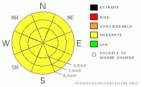
Danger Rose Tutorial
|
Rain up to fairly high elevations and seasonal midday warming will cause a rising danger of wet avalanches today, and you'll find a Level 2 or Moderate danger on most slopes in the backcountry. Heightened avalanche conditions exist, and triggered wet avalanches are possible on steep slopes at all elevations with soft saturated snow. There is also a Level 2 danger in drifted upper elevation terrain, where you might trigger large cornice falls or fresh shallow wind slab avalanches... Overrunning avalanches or cornice falls might trigger dangerous persistent slab avalanches on isolated slopes with lingering buried weak layers. Evaluate the snow and terrain carefully, and continue to practice safe travel protocols. |
|
|
CURRENT CONDITIONS |

|
The rain/snow-line will rise to near 9000' today, and we'll find coastal-like weather, cloudy and obscured skies, sustained and fairly strong west winds, and moist snow conditions in the backcountry... A couple inches of wet snow could accumulate at higher elevations today. The 8400' Tony Grove Snotel reports a constant 33 degrees and 4/10ths of an inch of water in the last 24 hrs, with no new snow reported. There's 131 inches of total snow at the station, with 157% of average water content for the date.. I'm also reading 33 degrees at the Hwy 89 Logan Summit Weather Station, which recorded strong and fairly sustained west-northwest winds overnight, with a midnight hourly average of 30 mph and gusts near 40.... |
|
|
RECENT ACTIVITY |

|
It was a quiet day yesterday in the Northern Utah backcountry avalanche-wise, and no new avalanches have been reported locally for the past several days...
.See our avalanche list HERE
|
|
|
THREAT #1 |

|
| WHERE |
PROBABILITY |
SIZE |
TREND |

|
|
|
|
| |
|
|
Over the next
12 hours.
|
|
|
Overnight temperatures hovered just above freezing and thick cloud-cover did not allow for much radiation cooling of the snow surface, so I'd expect only a superficial refreeze. The danger of wet avalanches will rise on many slopes as the saturated snow softens with inevitable midday heat. We'll be looking for areas with safer solid and supportable snow, and when we start sinking more deeply into soft saturated snow, we know it's time to leave... Be aware of trees or other potential terrain traps below you if you find you must venture on steep slopes with warmth softened snow.. |
|
|
THREAT #2 |

|
| WHERE |
PROBABILITY |
SIZE |
TREND |

|
|
|
|
| |
|
|
Over the next
24 hours.
|
|
|
Continue to avoid the large overhanging ridge-top cornices, which continue to build with sustained west winds and moist snow... These things are most likely to naturally fail in midday heat, but could be triggered anytime.. You could break huge cornices from much further back than you expect, and you can't see them when you approach from above... It's always wise to give the monsters lots of distance, and its better to stay well on the windward side of ridge crests. Cornice falls could trigger dangerous slab avalanches on steep slopes below. |
|
|
THREAT #3 |

|
| WHERE |
PROBABILITY |
SIZE |
TREND |

|
|
|
|
| |
|
|
Over the next
12 hours.
|
|
|
You might trigger fresh shallow wind slab avalanches at upper elevations on the lee sides of ridge lines and in and around terrain features like sub-ridges, gullies, scoops, and cliff bands.... You should avoid smooth, rounded, hollow sounding, or stiffer snow on steep slopes, especially above trees or other potential terrain traps... Dangerous persistent slab avalanches are rather unlikely yet still possible on isolated slopes with buried weak layers and poor snow structure.. Some avalanches may break a couple feet deep on a weak sugary layer sandwiched between melt-freeze crusts, or even more deeply buried mid-winter persistent weak layers. Persistent slab avalanches might be triggered by overrunning wet avalanches, cornice fall, or smaller wind slab avalanches... |
|
|
MOUNTAIN WEATHER |

|
Expect warmer temperatures today with a couple inches of snow possible at higher elevations and rain likely below around 8500'. Expect sustained west winds in the 20+mph range along the ridge-tops and mild mountain temperatures, with highs pushing upper 30s. The rain/snow-line and temperatures should drop overnight and 2 to 4 inches of accumulation is forecast with continuing west winds. Sunday's weather looks almost like a carbon-copy of today's, with a couple inches possible up high and fairly mild mountain temperatures. A stronger short wave will affect the zone Sunday night, Monday, and Monday night, with up to around a foot-and-a-half of accumulation possible.... |
|
|
GENERAL ANNOUNCEMENTS |
I'll update this advisory next weekend......
Help us improve the information we provide. Please take the time to answer 10 quick questions in our spring user survey... click HERE
You can view a photo summary of last year's avalanche activity in the Logan Area HERE
Join the friends of the Utah Avalanche Center in Logan on facebook. Click HERE
You have the opportunity to participate in the creation of our own community avalanche advisory by submitting avalanche and snow observations. You can also call us at 801-524-5304 or Toby at 435-757-7578, or email by clicking HERE
Donate to your favorite non-profit – The Friends of the Utah Avalanche Center. The UAC depends on contributions from users like you to support our work.
This advisory is from the U.S.D.A. Forest Service, which is solely responsible for its content. This advisory describes general avalanche conditions and local variations always occur. |
|
|
This information does not apply to developed ski areas or highways where avalanche control is normally done. This advisory is from the U.S.D.A. Forest Service, which is solely responsible for its content. This advisory describes general avalanche conditions and local variations always occur. |
|
This advisory provided by the USDA Forest Service, in partnership with:
The Friends of the Utah Avalanche Center, Utah Division of State Parks and Recreation, Utah Division of Emergency Management, Salt Lake County, Salt Lake Unified Fire Authority and the friends of the La Sal Avalanche Center. See our Sponsors Page for a complete list. |
