SPECIAL ANNOUNCEMENT |
 |
Through a generous donation by Backcountry.com to our partners the Friends of the Utah Avalanche Center we will continue forecasting until April 24th. I'll update this advisory tomorrow and again next weekend.. Thank You!! |
|
|
BOTTOM LINE
Danger by aspect and elevation on slopes approaching 35° or steeper.
(click HERE for tomorrow's danger rating)
|
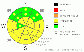
Danger Rose Tutorial
|
With nice cool temperatures this morning, there's a Level 1 or Low danger on most slopes in the backcountry. Solar and midday warming will cause a rising danger today, and I expect we'll find a Level 2 or Moderate danger developing on sunny slopes. Triggered wet avalanches will become possible on steep slopes with soft saturated snow. Heightened avalanche conditions also exist in drifted upper elevation terrain, where both large cornice fall and shallow wind slab avalanches are possible. Overrunning avalanches or cornice falls might trigger dangerous persistent slab avalanches on isolated slopes with lingering buried weak layers. Use normal caution, evaluate the snow and terrain carefully, and continue to practice safe travel protocols. |
|
|
CURRENT CONDITIONS |

|
Colder temperatures chilled out the sloppy snow from the heat earlier in the week, and the snow is pretty solid this morning in the backcountry. You certainly won't find nice deep powder like last weekend, but there's exceptionally good snow coverage considering that we're already in the middle of April.... You'll find a couple inches of new snow up high on a variable but mostly supportable and smooth melt/freeze crust from the warm conditions early in the week. The 8400' Tony Grove Snotel reports a cool 21 degrees and possibly another inch or two overnight. There's 134 inches of total snow at the station, with 155% of average water content for the date.. The CSI Logan Peak weather station at 9700' reports 15 degrees again this morning, and ridge top winds were from the west and northwest overnight.... |
|
|
RECENT ACTIVITY |

|
A party of skiers triggered a wind slab from below while ascending in Big Cottonwood Canyon in the Salt Lake Area Mountains yesterday. The avalanche caught one member of the party, carried him into a tree, and partially buried him leaving only his head, one arm, and pack out of the snow. The other skiers in the well spread out party were quickly able to free their partner, and there were no injuries reported. Locally; riders triggered a couple wide but fairly shallow wind slabs on Sunday above Tony Grove Lake, but nobody got caught. I received reports of several slow moving wet slabs also in the Tony Grove Area on Monday, and I observed evidence of a pretty big natural persistent slab release on a south facing slope in Wood Camp's Ham Hollow. More natural wet avalanches ran in the middle of the day on Tuesday.
.See our avalanche list HERE
|
|
|
THREAT #1 |

|
| WHERE |
PROBABILITY |
SIZE |
TREND |
|
|
|
|
| |
|
|
Over the next
12 hours.
|
|
|
Colder overnight temperatures the last couple nights really helped out conditions by refreezing the saturated snow, and the wet avalanche danger is low this morning since the snow is nice and solid. But the powerful spring sun will be out in full force today, and I expect it'll soften the snow up pretty rapidly. The danger will rise on many slopes with solar warming and midday heat. When you start sinking through the melt/freeze crust into the soft saturated snow below, it's time to leave... Be aware of trees or other potential terrain traps below you if you venture on steep slopes with warmth softened snow.. |
|
|
THREAT #2 |

|
| WHERE |
PROBABILITY |
SIZE |
TREND |
|
|
|
|
| |
|
|
Over the next
12 hours.
|
|
|
Colossal ridge top cornices are an obvious threat, especially viewed from below in midday warmth. These things are gargantuan, and you should avoid and stay out from under them this spring. Cornices have a nasty reputation of breaking further back than expected, and the likely box-car sized cornice falls could trigger dangerous avalanches on steep slopes below.
Also, you might trigger shallow wind slab avalanches at upper elevations on the lee sides of ridge lines and in and around terrain features like sub-ridges, gullies, scoops, and cliff bands.... You should avoid smooth, rounded, hollow sounding, or stiffer snow on steep slopes, especially above trees or other potential terrain traps... |
|
|
THREAT #3 |

|
| WHERE |
PROBABILITY |
SIZE |
TREND |
|
|
|
|
| |
|
|
Over the next
12 hours.
|
|
|
Dangerous persistent slab avalanches are unlikely yet still possible on slopes with buried weak layers and poor snow structure.. Some avalanches may break a couple feet deep on a weak sugary layer sandwiched between melt-freeze crusts. Deeper hard slab avalanches running on preserved mid-winter weak layers are possible on some steep and drifted upper elevation slopes, especially in rocky or generally shallow areas. I don't think that your weight alone will be enough to trigger one of these, but persistent slab avalanches might be triggered by overrunning wet avalanches, cornice fall, or smaller wind slab avalanches... |
|
|
MOUNTAIN WEATHER |

|
Temperatures will rise today with plenty of sun in the mountains this morning. High temperatures in the shade should stay a bit below freezing at 8500'.... Clouds will start streaming into the zone and southwest winds will increase a bit this afternoon ahead of the next weak Pacific storm, which will bring some snow, but little in the way of accumulation tonight.. Expect warmer temperatures tomorrow with a couple inches of snow possible at higher elevations and rain likely down low. Sunday's forecast is very similar, mild and moist, with little accumulation... |
|
|
GENERAL ANNOUNCEMENTS |
I'll update this advisory tomorrow and again next weekend......
Help us improve the information we provide. Please take the time to answer 10 quick questions in our spring user survey... click HERE
You can view a photo summary of last year's avalanche activity in the Logan Area HERE
Join the friends of the Utah Avalanche Center in Logan on facebook. Click HERE
You have the opportunity to participate in the creation of our own community avalanche advisory by submitting avalanche and snow observations. You can also call us at 801-524-5304 or Toby at 435-757-7578, or email by clicking HERE
Donate to your favorite non-profit – The Friends of the Utah Avalanche Center. The UAC depends on contributions from users like you to support our work.
This advisory is from the U.S.D.A. Forest Service, which is solely responsible for its content. This advisory describes general avalanche conditions and local variations always occur. |
|
|
This information does not apply to developed ski areas or highways where avalanche control is normally done. This advisory is from the U.S.D.A. Forest Service, which is solely responsible for its content. This advisory describes general avalanche conditions and local variations always occur. |
|
This advisory provided by the USDA Forest Service, in partnership with:
The Friends of the Utah Avalanche Center, Utah Division of State Parks and Recreation, Utah Division of Emergency Management, Salt Lake County, Salt Lake Unified Fire Authority and the friends of the La Sal Avalanche Center. See our Sponsors Page for a complete list. |
