BOTTOM LINE
Danger by aspect and elevation on slopes approaching 35° or steeper.
(click HERE for tomorrow's danger rating)
|
Danger Rose Tutorial
|
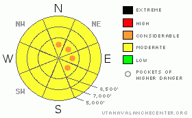
There's a Level 2 or Moderate danger in the backcountry, and heightened avalanche conditions exist on steep slopes at all elevations. I've included a few pockets with a Level 3 or Considerable danger at upper elevations due to overnight drifting, and you probably could trigger dangerous wind slab, and/or cornice fall avalanches in steep drifted terrain today. The danger of moist or wet avalanches entraining significant fresh snow on steep slopes will rise with seasonal midday warming, especially if the sun breaks through cloud cover. The danger of wet avalanches will certainly rise with the temperatures tomorrow on steep slopes. Dangerous persistent slab avalanches stepping into old snow are rather unlikely yet still possible and could be triggered by smaller overrunning avalanches or cornice falls. Continue to practice safe travel protocols, be aware of trees or other terrain traps below, and evaluate the snow and terrain carefully. |
|
|
CURRENT CONDITIONS |

|
You'll find super nice winter-like powder riding conditions at upper elevations, but you should also continue to use mid-season caution as several avalanche threats exist in the backcountry. Midday warming moistened the fresh snow at mid and lower elevations, so you'll likely see more of the same or some crusts today. The fresh snow from the last several days sits on a fairly supportable and decently refrozen base. The 8400' Tony Grove Snotel reports 22 degrees and a couple more inches of new snow containing 4/10ths of an inch of water. There's just under 12 feet, 142 inches, of total snow at the station, with 152% of average water content for the date... The Hwy 89 Logan Summit weather station reports sustained 20 mph west-northwest winds overnight, which certainly caused substantial drifting in exposed terrain. The CSI Logan Peak weather station at 9700' reports 15 degrees again this morning.... |
|
|
RECENT ACTIVITY |

|
Snow safety crews and backcountry riders reported soft slab and loose snow avalanche activity in the Wasatch and Uinta Mountains over the weekend... No avalanche activity was reported from the Logan Zone in the past couple days, but clouds and snowfall have been continually obscuring the mountain views.....
.See our avalanche list HERE
|
|
|
THREAT #1 |

|
| WHERE |
PROBABILITY |
SIZE |
TREND |

|
|
|
|
| |
|
|
Over the next
12 hours.
|
|
|
Winds from the west and northwest picked up and sustained drifting strength overnight. The freshly formed wind slabs may well be sensitive to human or cornice fall triggers today. You might trigger wind slab avalanches on the lee sides of ridge lines and in and around terrain features like sub-ridges, gullies, scoops, and cliff bands.... You should avoid smooth, rounded, hollow sounding, or stiffer snow on steep slopes, especially above trees or other potential terrain traps...
Colossal ridge top cornices are an obvious threat, especially viewed from below in midday warmth. These things are gargantuan, and you should avoid and stay out from under them this spring. Cornices have a nasty reputation of breaking further back than expected, and the likely box-car sized cornice falls could trigger dangerous avalanches on steep slopes below. |
|
|
THREAT #2 |

|
| WHERE |
PROBABILITY |
SIZE |
TREND |

|
|
|
|
| |
|
|
Over the next
36 hours.
|
|
|
You are likely to trigger loose dry avalanches or sluffs on upper elevation slopes steeper than about 35 degrees, and these could entrain significant quantities of fresh snow, especially on big hills. More importantly, the danger of moist or wet loose avalanches involving heavy warmed fresh snow will increase with seasonal and solar warming at all elevations irregardless of the direction a slope faces. Moist sluffs may fan out significantly and are likely to entrain all the fresh snow above last weekend's sun-crust. This threat will become a serious issue with direct solar warming or green-housing when the sun first escapes the persistent cloud cover, and the danger of wet avalanches will certainly rise with temperatures tomorrow... Be aware of trees or other potential terrain traps below you if you venture on steep slopes... |
|
|
THREAT #3 |

|
| WHERE |
PROBABILITY |
SIZE |
TREND |

|
|
|
|
| |
|
|
Over the next
12 hours.
|
|
|
Dangerous persistent and deep slab avalanches are unlikely yet still possible on slopes with buried weak layers and poor snow structure.. Some avalanches may break on a weak sugary layer above last weekend's melt and older surface rime-crust that is now sandwiched below a thin melt-freeze crust formed during warmer temperatures on Wednesday. And, with all the new weight from the latest storm, deeper hard slab avalanches running on preserved and reactivated mid-winter weak layers are possible on some steep and drifted upper elevation slopes, especially in rocky or generally shallow areas. Persistent slab avalanches might be triggered by overrunning soft slab, loose snow, cornice fall, or wind slab avalanches... |
|
|
MOUNTAIN WEATHER |

|
The storm will gradually exit the zone today, leaving lingering snow showers, clouds, and only gradually warming temperatures in it's wake. High temperatures in the mountains should stay in the lower 20s. Expect a bit of sunshine, warmer temperatures, and increasing wet avalanche danger tomorrow. Looks like the moist weather pattern will continue, with a series of weak storms lasting well into the coming week. Clouds and winds will increase late Monday and the next Pacific storm will impact the region with a few inches of snow likely on Tuesday.... |
|
|
GENERAL ANNOUNCEMENTS |
Help us improve the information we provide. Please take the time to answer 10 quick questions in our spring user survey... click HERE
You can view a photo summary of last year's avalanche activity in the Logan Area HERE
Join the friends of the Utah Avalanche Center in Logan on facebook. Click HERE
You have the opportunity to participate in the creation of our own community avalanche advisory by submitting avalanche and snow observations. You can also call us at 801-524-5304 or Toby at 435-757-7578, or email by clicking HERE
Donate to your favorite non-profit – The Friends of the Utah Avalanche Center. The UAC depends on contributions from users like you to support our work.
This advisory is from the U.S.D.A. Forest Service, which is solely responsible for its content. This advisory describes general avalanche conditions and local variations always occur. |
|
|
This information does not apply to developed ski areas or highways where avalanche control is normally done. This advisory is from the U.S.D.A. Forest Service, which is solely responsible for its content. This advisory describes general avalanche conditions and local variations always occur. |
|
This advisory provided by the USDA Forest Service, in partnership with:
The Friends of the Utah Avalanche Center, Utah Division of State Parks and Recreation, Utah Division of Emergency Management, Salt Lake County, Salt Lake Unified Fire Authority and the friends of the La Sal Avalanche Center. See our Sponsors Page for a complete list. |
