SPECIAL ANNOUNCEMENT |
 |
Despite the date, continuing winter snow conditions warrant caution and awareness in the backcountry, and I will issue morning forecasts through this weekend..... |
|
|
BOTTOM LINE
Danger by aspect and elevation on slopes approaching 35° or steeper.
(click HERE for tomorrow's danger rating)
|
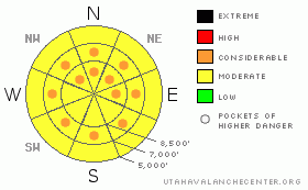
Danger Rose Tutorial
|
There's a Level 2 or Moderate danger in the backcountry, and heightened avalanche conditions exist on steep slopes at all elevations. Triggered dry and moist new snow, wind slab, and cornice fall avalanches are all possible in steep terrain today. The danger of moist or wet avalanches entraining significant fresh snow on steep slopes will rise with seasonal midday warming, especially if the sun breaks through cloud cover. Pockets with a Level 3 or Considerable danger exist in drifted terrain, and more will probably develop with midday warming, as the danger of loose wet avalanches becomes more widespread, especially at mid and lower elevations. Dangerous persistent slab avalanches stepping into old snow are rather unlikely yet still possible and could be triggered by smaller overrunning avalanches or cornice falls. Continue to practice safe travel protocols, be aware of trees or other terrain traps below, and evaluate the snow and terrain carefully today.... |
|
|
CURRENT CONDITIONS |

|
You'll still be able to find nice deep powder riding conditions at upper elevations, but midday warming yesterday moistened the fresh snow at mid and lower elevations, so crusts or slushy snow are likely today. The fresh snow from the last several days sits on a fairly supportable and decently refrozen base. The 8400' Tony Grove Snotel reports a couple more inches of new snow containing 3/10ths of an inch of water. There's just under 12 feet, 141 inches, of total snow at the station, with 152% of average water content for the date... Winds were pretty calm overnight in the mountains and the CSI Logan Peak weather station at 9700' reports 15 degrees this morning.... |
|
|
RECENT ACTIVITY |

|
During the intense storm on Thursday I noticed evidence of fairly extensive natural soft slab and loose snow avalanche activity off the steep slopes south and west of Tony Grove Lake. I triggered cracking in the new snow and a couple small loose sluffs that entrained a good amount of fresh snow on steep but small test slopes... No avalanche activity was reported from the Logan Zone yesterday, but snow safety crews and backcountry riders reported wind slab and moist avalanche activity in the Wasatch and Uinta Mountains....
.See our avalanche list HERE
|
|
|
THREAT #1 |

|
| WHERE |
PROBABILITY |
SIZE |
TREND |

|
|
|
|
| |
|
|
Over the next
12 hours.
|
|
|
Instabilities associated with the fresh snow are causing heightened avalanche conditions on steep slopes in the backcountry, with triggered dry and moist soft slab and loose snow avalanches possible in steep terrain at all elevations. You are likely to trigger loose dry avalanches or sluffs on upper elevation slopes steeper than about 35 degrees, and these could entrain significant quantities of fresh snow, especially on big slopes. The danger of moist or wet loose avalanches involving warmed fresh snow will increase at mid and lower elevations irregardless of the direction a slope faces, especially as temperatures warm around midday. Moist sluffs may fan out significantly and are likely to entrain all the fresh snow above last weekend's sun-crust. This threat will likely become more of an issue with solar warming next time the sun escapes the cloud cover... Be aware of trees or other potential terrain traps below you if you venture on steep slopes... |
|
|
THREAT #2 |

|
| WHERE |
PROBABILITY |
SIZE |
TREND |

|
|
|
|
| |
|
|
Over the next
12 hours.
|
|
|
Colossal ridge top cornices are an obvious threat, especially viewed from below in midday warmth. These things are gargantuan, and you should avoid and stay out from under them this spring. Cornices have a nasty reputation of breaking further back than expected, and box-car sized cornice falls could trigger dangerous avalanches on steep slopes below.
Couple-day-old wind slabs in exposed terrain are probably buried and obscured by a few inches of fresh snow that fell later in the storm after the winds diminished. Although probably fairly stubborn at this point, you might trigger wind slab avalanches on the lee sides of ridge lines and in and around terrain features like sub-ridges, gullies, scoops, and cliff bands.... You should avoid smooth, rounded, hollow sounding, or stiffer snow on steep slopes, especially above trees or other potential terrain traps... |
|
|
THREAT #3 |

|
| WHERE |
PROBABILITY |
SIZE |
TREND |

|
|
|
|
| |
|
|
Over the next
12 hours.
|
|
|
Dangerous persistent and deep slab avalanches are unlikely yet still possible on slopes with buried weak layers and poor snow structure.. Some avalanches may break on a weak sugary layer above last weekend's melt and older surface rime-crust that is now sandwiched below a thin melt-freeze crust formed during warmer temperatures on Wednesday. And, with all the new weight from the latest storm, deeper hard slab avalanches running on preserved and reactivated mid-winter weak layers are possible on some steep and drifted upper elevation slopes, especially in rocky or generally shallow areas. Persistent slab avalanches might be triggered by overrunning soft slab, loose snow, cornice fall, or wind slab avalanches... |
|
|
MOUNTAIN WEATHER |

|
The storm will gradually exit the zone today, leaving lingering snow showers, clouds, and only gradually warming temperatures in it's wake. A few additional inches of accumulation is forecast...High temperatures in the mountains will stay in the lower 20s and the currently calm winds will pick up a bit this afternoon from the west and northwest. Looks like the moist weather pattern will continue into the coming week... Expect a few more inches of accumulation overnight tonight, with increasing moderate winds shifting out of the west-southwest. More snowfall is expected tomorrow, but accumulations should be fairly light.... The strong spring sun may come out for a while on Monday and much warmer temperatures are likely in the mountains... |
|
|
GENERAL ANNOUNCEMENTS |
Help us improve the information we provide. Please take the time to answer 10 quick questions in our spring user survey... click HERE
You can view a photo summary of last year's avalanche activity in the Logan Area HERE
Join the friends of the Utah Avalanche Center in Logan on facebook. Click HERE
We will be ending our regular advisories for the season this weekend.....
You have the opportunity to participate in the creation of our own community avalanche advisory by submitting avalanche and snow observations. You can also call us at 801-524-5304 or Toby at 435-757-7578, or email by clicking HERE
Donate to your favorite non-profit – The Friends of the Utah Avalanche Center. The UAC depends on contributions from users like you to support our work.
This advisory is from the U.S.D.A. Forest Service, which is solely responsible for its content. This advisory describes general avalanche conditions and local variations always occur. |
|
|
This information does not apply to developed ski areas or highways where avalanche control is normally done. This advisory is from the U.S.D.A. Forest Service, which is solely responsible for its content. This advisory describes general avalanche conditions and local variations always occur. |
|
This advisory provided by the USDA Forest Service, in partnership with:
The Friends of the Utah Avalanche Center, Utah Division of State Parks and Recreation, Utah Division of Emergency Management, Salt Lake County, Salt Lake Unified Fire Authority and the friends of the La Sal Avalanche Center. See our Sponsors Page for a complete list. |
