SPECIAL ANNOUNCEMENT |
 |
The UAC is CLOSING AFTER THIS WEEKEND: Today will be our last of issuing regular advisories for the season as our piggy bank has run dry. We will continue to accept and publish observations from backcountry users who submit them. You can find them in the Current Conditions off the main menu.
Help us improve the information we provide. Please take the time to answer 10 quick questions in our spring user survey... click HERE |
|
|
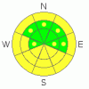
BOTTOM LINE
Danger by aspect and elevation on slopes approaching 35° or steeper.
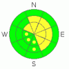
(click HERE for tomorrow's danger rating)
|
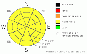
Danger Rose Tutorial
|
There's a Level 2 or Moderate danger and heightened avalanche conditions exist on many slopes in the backcountry. Despite welcome colder temperatures overnight, wet avalanches involving fresh snow and perhaps saturated older snow are possible on steep slopes, mainly at mid and lower elevations. You could trigger shallow wind slabs consisting of fresh snow in drifted upper and mid elevation terrain, and continuing west and northwest winds today will likely cause the danger to become more widespread. There is still a danger of cornice falls at upper elevations, and you might trigger large avalanches if you travel close to the edge of exposed ridges... Dangerous and destructive deep slab avalanches are rather unlikely but still possible on some upper and mid-elevation slopes and could be triggered by overrunning cornice fall, fresh wind slab, or loose wet avalanches.. Continue to practice safe travel protocols, be aware of trees or other terrain traps below, and evaluate the snow and terrain carefully today.... |
|
|
CURRENT CONDITIONS |

|
Most stations in the Bear River Range report 5 or 6 inches of new snow from overnight, and temperatures dropped dramatically. The CSI weather station on Logan Peak reports 10 degrees this morning and its a cool 19 degrees up at the 8400' Tony Grove Snotel. The station reports 6" of new snow and there's 133 inches of total snow at the station, with 147% of average water content for the date... The highway 89 Logan Summit weather station reports moderate westerly winds from overnight. |
|
|
RECENT ACTIVITY |

|
The rapid warm-up on Thursday and continued heat this weekend spawned numerous natural wet avalanches across the Logan Zone... Looks like natural cornice falls, caused by the heat, triggered large avalanches at upper elevations in the Tony Grove Area, including a broad persistent hard slab in North Castle Rock and a very long-running and large cornice fall avalanche off Cornice Ridge....
.See our avalanche list HERE
|
|
|
THREAT #1 |

|
| WHERE |
PROBABILITY |
SIZE |
TREND |
|
|
|
|
| |
|
|
Over the next
12 hours.
|
|
|
The colder temperatures help a lot, but a few inches of new snow only insulated the rain soaked and heat saturated snow at mid and lower elevations. Loose wet avalanches involving the fresh snow are possible as temperatures warm around midday. Wet avalanches involving soft isothermal older snow are also possible on some steep slopes..... This threat will likely become more of an issue with warmer temperatures and sun tomorrow... |
|
|
THREAT #2 |

|
| WHERE |
PROBABILITY |
SIZE |
TREND |
|
|
|
|
| |
|
|
Over the next
12 hours.
|
|
|
Continue to avoid and stay out from under the huge overhanging cornices on the major ridge lines, which often break further back than expected and could trigger dangerous avalanches on steep slopes below. West and northwest winds today will drift fresh snow into deposition areas, forming shallow and probably sensitive wind slabs in exposed terrain... You should avoid fresh smooth, rounded, or stiffer drifts on steep slopes, especially above trees or other potential terrain traps... |
|
|
THREAT #3 |

|
| WHERE |
PROBABILITY |
SIZE |
TREND |

|
|
|
|
| |
|
|
Over the next
12 hours.
|
|
|
Dangerous persistent and deep slab avalanches are still possible on slopes with buried weak layers and poor snow structure.. The danger is highest on steep drifted upper elevation slopes, especially in rocky areas or areas with a generally shallow snowpack. Deep slab avalanches will probably still need a fairly large trigger like overrunning cornice falls or wind slab avalanches from above, but if they occur they'll be impressive, quite destructive, and potentially deadly.... |
|
|
MOUNTAIN WEATHER |

|
The storm will exit the zone today, leaving a few lingering snow showers, clouds, and much cooler temperatures in it's wake. High temperatures in the mountains will stay in the lower 20s and sustained 15 -20 mph northwest winds along the ridges will keep things chilly and drift the fresh snow around. High pressure will begin to build over the region tomorrow, with partly cloudy skies and warmer conditions.... Temperatures will rise above freezing again on Tuesday ahead of the next Pacific system, which will bring a chance for a few inches of snowfall and another cool down on Tuesday night.... |
|
|
GENERAL ANNOUNCEMENTS |
You can view a photo summary of last year's avalanche activity in the Logan Area HERE
Join the friends of the Utah Avalanche Center in Logan on facebook. Click HERE
We will be ending our regular advisories for the season this weekend.....
You have the opportunity to participate in the creation of our own community avalanche advisory by submitting avalanche and snow observations. You can also call us at 801-524-5304 or Toby at 435-757-7578, or email by clicking HERE
Donate to your favorite non-profit – The Friends of the Utah Avalanche Center. The UAC depends on contributions from users like you to support our work.
This advisory is from the U.S.D.A. Forest Service, which is solely responsible for its content. This advisory describes general avalanche conditions and local variations always occur. |
|
|
This information does not apply to developed ski areas or highways where avalanche control is normally done. This advisory is from the U.S.D.A. Forest Service, which is solely responsible for its content. This advisory describes general avalanche conditions and local variations always occur. |
|
This advisory provided by the USDA Forest Service, in partnership with:
The Friends of the Utah Avalanche Center, Utah Division of State Parks and Recreation, Utah Division of Emergency Management, Salt Lake County, Salt Lake Unified Fire Authority and the friends of the La Sal Avalanche Center. See our Sponsors Page for a complete list. |
