SPECIAL ANNOUNCEMENT |
 |
The UAC is CLOSING AFTER THIS WEEKEND: This weekend will be our last of issuing advisories for the season as our piggy bank has run dry. We will continue to accept and publish observations from backcountry users who submit them. You can find them in the Current Conditions off the main menu.
Help us improve the information we provide. Please take the time to answer 10 quick questions in our spring user survey... click HERE |
|
|
BOTTOM LINE
Danger by aspect and elevation on slopes approaching 35° or steeper.
(click HERE for tomorrow's danger rating)
|
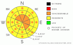
Danger Rose Tutorial
|
Warm temperatures created heightened avalanche conditions in the backcountry, and there's a Level 2 or Moderate danger of wet avalanches on steep slopes at all elevations. Dangerous conditions and pockets of Level 3 exist in places, and triggered wet avalanches are likely on steep slopes with saturated snow. Dangerous and destructive deep slab avalanches are possible on some upper and mid-elevation slopes and could be triggered by overrunning cornice fall or loose wet avalanches.. There is a Level 3 or Considerable danger of cornice falls at upper elevations, and you are likely to trigger large avalanches if you travel close to the edge of exposed ridges this weekend. Careful snowpack evaluation, cautious route finding, and conservative decision making are essential in avalanche terrain. |
|
|
CURRENT CONDITIONS |

|
Riding conditions are poor in the backcountry and very warm temperatures in the past few days created dangerous wet avalanche conditions at all elevations... With the exceptionally warm temperatures overnight, I wouldn't expect to find much of a surface refreeze, and you'll still find saturated snow conditions in many areas today. It has not dropped below freezing overnight for the last three nights up at the 8400' Tony Grove Snotel, and mountain temperatures are in the mid 40s this morning. It's 45 degrees this morning and there's still 128 inches of total snow at the station, with 148% of average water content for the date... |
|
|
RECENT ACTIVITY |

|
The rapid warm-up on Thursday and continued heat yesterday spawned numerous natural wet avalanches across the Logan Zone... Looks like natural cornice falls, caused by the heat, triggered large avalanches at upper elevations in the Tony Grove Area, including a persistent hard slab in North Castle Rock and a very long-running slide in Cornice Ridge....
.See our avalanche list HERE
|
|
|
THREAT #1 |

|
| WHERE |
PROBABILITY |
SIZE |
TREND |
|
|
|
|
| |
|
|
Over the next
12 hours.
|
|
|
Increasing wind and clouds will hopefully help by cooling the saturated snow, but seasonal warmth or green-housing are likely to heat things up again, and with no good overnight refreeze, dangerous wet avalanches are possible on many steep slopes... Today you should avoid steep terrain with saturated snow, especially steep slopes with trees, gullies, or other terrain traps below. |
|
|
THREAT #2 |

|
| WHERE |
PROBABILITY |
SIZE |
TREND |
|
|
|
|
| |
|
|
Over the next
24 hours.
|
|
|
Dangerous persistent and deep slab avalanches are still possible on slopes with buried weak layers and poor snow structure.. The danger is highest on steep previously drifted upper elevation slopes, especially in rocky areas or areas with a generally shallow snowpack. The recent warmth increased slab creep rates and softened hard slab layers. Deep slab avalanches will probably need a fairly large trigger like overrunning cornice falls or loose wet avalanches from above, but if they occur they'll be impressive, quite destructive, and potentially deadly.... |
|
|
THREAT #3 |

|
| WHERE |
PROBABILITY |
SIZE |
TREND |
|
|
|
|
| |
|
|
Over the next
12 hours.
|
|
|
Continue to avoid and stay out from under the huge overhanging cornices on the major ridge lines, which often break further back than expected and could trigger dangerous avalanches on steep slopes below. The continuing warm temperatures caused these monsters to sag, buckle, and some to naturally fail in the heat of the day... More boxcar or even small train-sized cornice falls are possible in the backcountry today. |
|
|
MOUNTAIN WEATHER |

|
Warm, springlike temperatures will continue into this afternoon, with increasing winds and cloud cover . Rain is possible ahead of and with the frontal passage this evening, and a good shot of snow is likely tonight. 9 to 13 inches of accumulation is forecast, and it will come quickly overnight, creating a rising danger of wind slab and storm snow avalanches, in case you're planning on spending the night out or getting an early morning powder run..The storm will taper off tomorrow and it'll be pleasantly cold. The seasonal c-saw of warmth-storm-cold weather will continue through next week, with another storm probable around Wednesday.... |
|
|
GENERAL ANNOUNCEMENTS |
You can view a photo summary of last year's avalanche activity in the Logan Area HERE
Join the friends of the Utah Avalanche Center in Logan on facebook. Click HERE
We will be ending our regular advisories for the season this weekend.....
You have the opportunity to participate in the creation of our own community avalanche advisory by submitting avalanche and snow observations. You can also call us at 801-524-5304 or Toby at 435-757-7578, or email by clicking HERE
Donate to your favorite non-profit – The Friends of the Utah Avalanche Center. The UAC depends on contributions from users like you to support our work.
This advisory is from the U.S.D.A. Forest Service, which is solely responsible for its content. This advisory describes general avalanche conditions and local variations always occur. |
|
|
This information does not apply to developed ski areas or highways where avalanche control is normally done. This advisory is from the U.S.D.A. Forest Service, which is solely responsible for its content. This advisory describes general avalanche conditions and local variations always occur. |
|
This advisory provided by the USDA Forest Service, in partnership with:
The Friends of the Utah Avalanche Center, Utah Division of State Parks and Recreation, Utah Division of Emergency Management, Salt Lake County, Salt Lake Unified Fire Authority and the friends of the La Sal Avalanche Center. See our Sponsors Page for a complete list. |
