SPECIAL ANNOUNCEMENT |
 |
Help us improve the information we provide. Please take the time to answer 10 quick questions in our spring user survey... click HERE |
|
|
BOTTOM LINE
Danger by aspect and elevation on slopes approaching 35° or steeper.
(click HERE for tomorrow's danger rating)
|
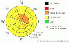
Danger Rose Tutorial
|
There is a Level 3 or Considerable danger in drifted upper elevation terrain, and dangerous avalanche conditions exist. You are likely to trigger large cornice fall and wind slab avalanches if you travel on steep drifted upper elevation slopes or too close to the edge of exposed ridges. Dangerous and destructive deep slab avalanches are possible on some drifted upper and mid-elevation slopes and could be triggered by overrunning cornice fall or wind slab avalanches.. The danger is Level 2 or Moderate on the majority of other steep slopes in the zone, and you'll find safer conditions at lower elevations, on lower angled slopes, and in sheltered terrain. Seasonal warning or green-housing might create a danger of wet avalanches on steep slopes with moist fresh snow on the surface. Significant warming Thursday will likely cause the wet avalanche threat to become much more widespread.. Careful snowpack evaluation, cautious route finding, and conservative decision making are essential in avalanche terrain today. |
|
|
CURRENT CONDITIONS |

|
There is lots of fresh powder in the backcountry, and you will still be able to find great riding conditions especially in safer, sheltered and lower angled terrain.. A bit of green-housing around midday yesterday caused the lower elevation snow to stiffen up and get a bit sticky. The Tony Grove Snotel at 8400' reported another foot of snow with 1.2 inches of water from Monday's storm, and there is a bit more than 12 feet of total snow at the site.... Intensifying west winds today will find plenty of soft snow for drifting at upper elevations.... |
|
|
RECENT ACTIVITY |

|
Huge natural deep slab avalanches from over the weekend are still being assessed in the Provo Area Mountains, and a large natural from Monday night was reported in the Central Wasatch. Locally, yesterday I could see the expected evidence of natural cornice fall and wind slab avalanche activity on the big east faces of the Wellsville Range, but I didn't note anything extraordinary... A skier triggered and skied out of a small soft slab in Providence Canyon on the steep slope above the mid-canyon Green Gate yesterday afternoon. The foot deep by 30' wide avalanche on a west facing slope at around 7400'in elevation generated some speed and overran the bottom of the popular Dogleg up-track... Riders also reported a "small" triggered avalanche somewhere in the Providence Peak area....
.See our avalanche list HERE
|
|
|
THREAT #1 |

|
| WHERE |
PROBABILITY |
SIZE |
TREND |
|
|
|
|
| |
|
|
Over the next
24 hours.
|
|
|
Continue to avoid and stay out from under the huge overhanging cornices on the major ridge lines, which often break further back than expected and could trigger dangerous avalanches on steep slopes below. You should not take this threat lightly, as cornice falls are the suspected triggers of numerous local natural deep slab avalanches and Saturday's fatal accident in Central Utah....
Avoid fresh wind slabs on steep slopes in lee terrain and deceleration zones or deposition areas... Substantial accumulations and sustained strong south and west winds have created dangerous avalanche conditions on drifted slopes... Triggered wind slab avalanches 1 to 3 feet deep are probable on steep drifted slopes, especially in upper elevation terrain... |
|
|
THREAT #2 |

|
| WHERE |
PROBABILITY |
SIZE |
TREND |
|
|
|
|
| |
|
|
Over the next
24 hours.
|
|
|
Dangerous deep slab avalanches are possible and most likely on slopes facing the northern quadrant of the compass. The significant load of new snow from last week was apparently enough to reactivate deeply buried, mid-winter weak layers in some areas... Today's load of drifted new snow may help tip the load on slopes that are already close to the critical balance.... Deep slab avalanches will probably need a fairly large trigger like overrunning cornice falls or fresh wind slab avalanches, which have been the apparent culprit triggers in local deep slab activity over the last month. So, you certainly don't want to get caught by a cornice fall or a smaller wind slab because any avalanche stepping down into deeply buried weak layers will be very large, dangerous and potentially deadly... |
|
|
THREAT #3 |

|
| WHERE |
PROBABILITY |
SIZE |
TREND |
|
|
|
|
| |
|
|
Over the next
24 hours.
|
|
|
Moist sluffs will become possible on any slope warmed by seasonal solar warming or green-housing if the sun happens to peak out from behind the clouds for even a bit. The threat of wet avalanches will likely increase significantly and become more widespread with warming temperatures tomorrow. |
|
|
MOUNTAIN WEATHER |

|
West winds at upper elevations will intensify into the afternoon, and I expect that drifting will be a significant factor at upper elevations today. Snow is likely, but accumulations will be light. A high pressure will gain control over the weather pattern heading into the later half of the week and seriously warming temperatures will produce the next avalanche concern for Thursday and Friday... Another moist Pacific storm is expected for the weekend and more accumulating snow is expected... |
|
|
GENERAL ANNOUNCEMENTS |
You can view a photo summary of last year's avalanche activity in the Logan Area HERE
Join the friends of the Utah Avalanche Center in Logan on facebook. Click HERE
I will update this advisory in the mornings on Mondays, Wednesdays, Fridays, and Saturdays, but we will be ending our regular advisories for the season next week....
You have the opportunity to participate in the creation of our own community avalanche advisory by submitting avalanche and snow observations. You can also call us at 801-524-5304 or Toby at 435-757-7578, or email by clicking HERE
Donate to your favorite non-profit – The Friends of the Utah Avalanche Center. The UAC depends on contributions from users like you to support our work.
This advisory is from the U.S.D.A. Forest Service, which is solely responsible for its content. This advisory describes general avalanche conditions and local variations always occur. |
|
|
This information does not apply to developed ski areas or highways where avalanche control is normally done. This advisory is from the U.S.D.A. Forest Service, which is solely responsible for its content. This advisory describes general avalanche conditions and local variations always occur. |
|
This advisory provided by the USDA Forest Service, in partnership with:
The Friends of the Utah Avalanche Center, Utah Division of State Parks and Recreation, Utah Division of Emergency Management, Salt Lake County, Salt Lake Unified Fire Authority and the friends of the La Sal Avalanche Center. See our Sponsors Page for a complete list. |
