SPECIAL ANNOUNCEMENT |
 |
We have issued a Special Avalanche Statement for continued complex and tricky avalanche conditions for the northern and central Utah mountains.
Yesterday Garret Smith died from injuries sustained in the huge avalanche their party triggered on the Manti Skyline two days ago. Our deepest condolences go out to his friends and family. A big thanks to the heroic rescue by the Sanpete County Search and Rescue.
Grant and Brett visited the site yesterday and posted a complete report..... |
|
|
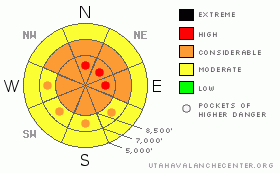
BOTTOM LINE
Danger by aspect and elevation on slopes approaching 35° or steeper.
(click HERE for tomorrow's danger rating)
|
Danger Rose Tutorial
|
There is a Level 3 or Considerable danger on many slopes in the backcountry, and dangerous avalanche conditions exist on corniced ridge lines, on steep drifted slopes, and on slopes with significant deposits of new snow. You are likely to trigger large cornice fall and wind slab avalanches if you travel on steep drifted upper elevation slopes or too close to the edge on exposed ridges. In these areas, there are pockets with a Level 4 or High danger, and some natural avalanches are likely today during periods of heavy snowfall and/or sustained strong winds.. Dangerous and destructive deep slab avalanches are possible on some drifted upper and mid-elevation slopes and could be triggered by overrunning cornice fall, wind slab, or large loose avalanches.. Dry or moist loose snow avalanches or sluffs are likely on steep slopes and will be manageable from above, but could be dangerous to anyone below, especially around trees or other terrain traps. You'll find safer conditions in the backcountry at lower elevations, on lower angled slopes, and in sheltered terrain. Careful snowpack evaluation, cautious route finding, and conservative decision making are essential in avalanche terrain today. |
|
|
RECENT ACTIVITY |

|
In addition to the tragic accident on the Manti Skyline, we received reports of three other people caught and carried by avalanches, with at least one injured, over the weekend in the Central Wasatch Range. Locally, other than manageable loose snow avalanches or sluffs on steep slopes, no avalanche were reported over the weekend in the Logan Area. Riders observed several large natural deep slab avalanches in the zone last week, and a couple smaller snowmobile triggered slides were reported second hand....
.See our avalanche list HERE
|
|
|
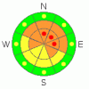
THREAT #1 |

|
| WHERE |
PROBABILITY |
SIZE |
TREND |
|
|
|
|
| |
|
|
Over the next
24 hours.
|
|
|
Continue to avoid and stay out from under the huge overhanging cornices on the major ridge lines, which often break further back than expected and could trigger dangerous avalanches on steep slopes below. You should not take this threat lightly, as cornice falls are the suspected triggers of numerous local natural deep slab avalanches and Saturday's fatal accident in Central Utah....
Avoid fresh wind slabs on steep slopes in lee terrain and deceleration zones or deposition areas... Substantial accumulations and sustained strong south and west winds have created dangerous avalanche conditions on drifted slopes... Triggered wind slab avalanches 1 to 3 feet deep are probable on steep drifted slopes, especially in upper elevation terrain... Natural cornice falls and wind slabs are also likely today, especially during periods of heavy snowfall and/or strong and sustained winds... |
|
|
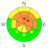
THREAT #2 |

|
| WHERE |
PROBABILITY |
SIZE |
TREND |
|
|
|
|
| |
|
|
Over the next
24 hours.
|
|
|
Dangerous deep slab avalanches are possible and most likely on slopes facing the northern quadrant of the compass. The significant load of new snow from last week was apparently enough to reactivate deeply buried, mid-winter weak layers in some areas... Today's load of drifted new snow may help tip the load on slopes that are already close to the critical balance.... Deep slab avalanches will probably need a fairly large trigger like overrunning cornice falls or fresh wind slab avalanches, which have been the apparent culprit triggers in local deep slab activity over the last month. So, you certainly don't want to get caught by a cornice fall or a smaller wind slab because any avalanche stepping down into deeply buried weak layers will be very large, dangerous and potentially deadly... |
|
|
THREAT #3 |

|
| WHERE |
PROBABILITY |
SIZE |
TREND |

|
|
|
|
| |
|
|
Over the next
24 hours.
|
|
|
Sot slabs consisting of new snow and failing on density inversions, interfaces, or other short-lived storm snow threats are likely today in some areas. Loose snow avalanches or sluffs are likely on steep slopes with significant deposits of fresh snow... These will most likely still be of the dry variety today and will be generally manageable from above.. Moist sluffs will become possible on any slope warmed by seasonal solar warming or green-housing if the sun happens to peak out from behind the clouds for even a bit. |
|
|
MOUNTAIN WEATHER |

|
Snowfall will resume in the zone today and is likely to be heavy at times, with up to around a foot of accumulation possible at upper elevations by this evening... Sustained west winds at upper elevations will calm a bit this afternoon, but I expect that drifting will be a significant factor again today. A weak system will impact the region Tuesday night, but accumulations look insignificant at this time.... High pressure will gain control over the weather pattern heading into the later half of the week and seriously warming temperatures will produce the next avalanche concern... |
|
|
GENERAL ANNOUNCEMENTS |
Help us improve the information we provide. Please take the time to answer 10 quick questions in our spring user survey... click HERE
You can view a photo summary of last year's avalanche activity in the Logan Area HERE
Join the friends of the Utah Avalanche Center in Logan on facebook. Click HERE
I will update this advisory in the mornings on Mondays, Wednesdays, Fridays, and Saturdays, and on other days if backcountry avalanche conditions warrant...
You have the opportunity to participate in the creation of our own community avalanche advisory by submitting avalanche and snow observations. You can also call us at 801-524-5304 or Toby at 435-757-7578, or email by clicking HERE
Donate to your favorite non-profit – The Friends of the Utah Avalanche Center. The UAC depends on contributions from users like you to support our work.
This advisory is from the U.S.D.A. Forest Service, which is solely responsible for its content. This advisory describes general avalanche conditions and local variations always occur. |
|
|
This information does not apply to developed ski areas or highways where avalanche control is normally done. This advisory is from the U.S.D.A. Forest Service, which is solely responsible for its content. This advisory describes general avalanche conditions and local variations always occur. |
|
This advisory provided by the USDA Forest Service, in partnership with:
The Friends of the Utah Avalanche Center, Utah Division of State Parks and Recreation, Utah Division of Emergency Management, Salt Lake County, Salt Lake Unified Fire Authority and the friends of the La Sal Avalanche Center. See our Sponsors Page for a complete list. |
