SPECIAL ANNOUNCEMENT |
 |
Help us improve the information we provide. Please take the time to answer 10 quick questions in our spring user survey... click HERE |
|
|
BOTTOM LINE
Danger by aspect and elevation on slopes approaching 35° or steeper.
(click HERE for tomorrow's danger rating)
|
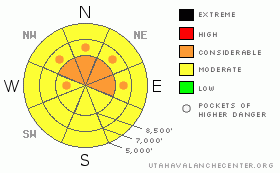
Danger Rose Tutorial
|
There is a Level 2 or Moderate danger on many slopes in the backcountry, and heightened avalanche conditions exist on corniced ridge lines, on steep drifted slopes, and on slopes with significant deposits of new snow. A Level 3 or Considerable danger persists on some slopes in drifted upper elevation terrain, and there are areas with dangerous avalanche conditions... You are likely to trigger large cornice fall and wind slab avalanches if you travel on steep drifted upper elevation slopes or to close to the edge on exposed ridges. Dangerous and destructive deep slab avalanches are still possible on some drifted upper elevation slopes, especially on those with poor snow structure and those overrun by wind slab or cornice fall avalanches. Dry or moist loose snow avalanches or sluffs are likely on steep slopes and are mostly manageable from above, but could be dangerous around trees or other terrain traps....You'll find safer conditions this weekend at lower elevations, on lower angled slopes, and in sheltered terrain. Careful snowpack evaluation, cautious route finding, and conservative decision making are essential in avalanche terrain today. |
|
|
CURRENT CONDITIONS |

|
While dangerous avalanche conditions exist on some drifted upper elevation slopes, there are many areas with fairly stable snow and good powder riding... You'll find a few inches of new snow on a sun-crust at lower elevations. The Tony Grove Snotel at 8400' reports 5 new inches snow with 5/10ths of an inch of water from yesterday...It's 18 degrees this morning and there is 133 inches of total snow with 144% of average water content for the date. |
|
|
RECENT ACTIVITY |

|
Locally, riders this week observed evidence of large fresh natural deep slab avalanches off Millville and Providence Peaks in Providence Canyon and Cornice Ridge and Castle Rock in the Tony Grove Area... It appears that these were triggered by cornice fall or overrunning wind slab avalanches, and they all occurred sometime in the morning on Tuesday (3-22-11).. This was during a period of particularly heavy snowfall and strong winds.... I was able to get up to the Millville Peak and Castle Rock Avalanches... Both are classified as hard slab avalanches, and they both failed on very thin persistent weak layers. But, the failing layers were different, with the 3-4' deep, 150' wide Millville Peak slab failing on a thin layer of frost or surface hoar, and the 6-10' deep, 500' wide Castle Rock hard slab failing on small sugary facets. I also received reports of unintentional snowmobile triggered wind slab avalanches Wednesday and Thursday in Providence Canyon and White Pine...
.See our avalanche list HERE
|
|
|
THREAT #1 |

|
| WHERE |
PROBABILITY |
SIZE |
TREND |
|
|
|
|
| |
|
|
Over the next
24 hours.
|
|
|
Continue to avoid and stay out from under the huge overhanging cornices on the major ridge lines, which often break further back than expected and could trigger dangerous avalanches on steep slopes below.
Also avoid fresh wind slabs on steep slopes in lee terrain and deceleration zones or deposition areas... Substantial accumulations and sustained strong south southwest winds have created heightened avalanche conditions on drifted slopes... Triggered wind slab avalanches 1 to 2 feet deep are probable on steep drifted slopes, especially in upper elevation terrain... |
|
|
THREAT #2 |

|
| WHERE |
PROBABILITY |
SIZE |
TREND |
|
|
|
|
| |
|
|
Over the next
24 hours.
|
|
|
Dangerous deep slab avalanches are possible and most likely on slopes facing the northern quadrant of the compass. The significant load of new snow from Monday and Tuesday is apparently enough to reactivate deeply buried, mid-winter weak layers in some areas... This weekend's load of drifted new snow may help tip the load on slopes that are already close to the critical balance.... Deep slab avalanches will probably need a fairly large trigger like overrunning cornice falls or fresh wind slab avalanches. But if you trigger one, watch out, because it could certainly pack a destructive and potentially deadly punch... |
|
|
THREAT #3 |

|
| WHERE |
PROBABILITY |
SIZE |
TREND |
|
|
|
|
| |
|
|
Over the next
24 hours.
|
|
|
Loose snow avalanches or sluffs are likely on steep slopes with significant deposits of fresh snow... These will most likely still be of the dry variety today and will be generally manageable from above.. Moist sluffs will become possible on any slope warmed by seasonal solar warming or green-housing if the sun happens to peak out from behind the clouds this morning.... |
|
|
MOUNTAIN WEATHER |

|
After a short-lived break today, snowfall and strong southwest winds will resume this evening and continue through the remainder of the weekend..... One to two feet of additional accumulation is possible at upper elevations by Monday morning. Southwest winds will begin to intensify today and be fairly strong overnight, so we can expect further extensive drifting to occur and a rising avalanche danger... Looks like moist weather will continue through the early part of next week and the serious warming and fair weather will hit with a high pressure system on around Thursday.... |
|
|
GENERAL ANNOUNCEMENTS |
You can view a photo summary of last year's avalanche activity in the Logan Area HERE
Join the friends of the Utah Avalanche Center in Logan on facebook. Click HERE
I will update this advisory in the mornings on Mondays, Wednesdays, Fridays, and Saturdays, and on other days if backcountry avalanche conditions warrant...
You have the opportunity to participate in the creation of our own community avalanche advisory by submitting avalanche and snow observations. You can also call us at 801-524-5304 or Toby at 435-757-7578, or email by clicking HERE
Donate to your favorite non-profit – The Friends of the Utah Avalanche Center. The UAC depends on contributions from users like you to support our work.
This advisory is from the U.S.D.A. Forest Service, which is solely responsible for its content. This advisory describes general avalanche conditions and local variations always occur. |
|
|
This information does not apply to developed ski areas or highways where avalanche control is normally done. This advisory is from the U.S.D.A. Forest Service, which is solely responsible for its content. This advisory describes general avalanche conditions and local variations always occur. |
|
This advisory provided by the USDA Forest Service, in partnership with:
The Friends of the Utah Avalanche Center, Utah Division of State Parks and Recreation, Utah Division of Emergency Management, Salt Lake County, Salt Lake Unified Fire Authority and the friends of the La Sal Avalanche Center. See our Sponsors Page for a complete list. |
