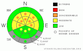
BOTTOM LINE
Danger by aspect and elevation on slopes approaching 35° or steeper.
(click HERE for tomorrow's danger rating)
|
Danger Rose Tutorial
|
This morning there is a Level 2 or Moderate danger and heightened avalanche conditions exist on drifted upper elevation slopes in the Logan Zone. There are also pockets with a Level 3 danger, and you are likely to trigger 1 to 2 foot deep wind slab avalanches and/or large cornice falls if you travel on steep drifted slopes or ridge-tops, mainly in upper elevation terrain. A winter storm with heavy snowfall and strong wind will create a rising danger throughout the day and dangerous conditions may develop. The danger will become more widespread and will probably rise to Level 3 or Considerable by this evening. Continue to use safe travel protocols and evaluate the snow and terrain carefully. |
|
|
CURRENT CONDITIONS |

|
The National Weather Service issued a Winter Storm Warning starting later this morning through tomorrow, and you'll get to experience some "full on" weather in the mountains today. The now somewhat refrozen old snow is firm and supportable at lower and mid elevations and on most sunny slopes, and a few inches of capping fresh and kind of dusty snow makes for an enjoyable and safer riding option, especially on lower angled slopes... In sheltered areas, you'll find a few inches of fresh snow on soft settled powder in shady terrain above around 8000' in elevation.
The Tony Grove Snotel reports 3 inches of new snow in the last 48 hours. It's 28 degrees and there is 120 inches of total snow with 139% of average water content for the date. It's 25degrees at the CSI weather station on Logan Peak at 9700'. Strong south winds continued overnight, with a bit of an easterly component at times. Mt. Ogden reports 30-35 mph average wind speeds this morning and gusts close to 60 mph.... |
|
|
RECENT ACTIVITY |

|
We've received reports of sensitive cornice and triggered and natural wind slab avalanches across the mountains of northern Utah... Locally, riders report a fresh and broad wind slab avalanche off Horse Ridge (or the east ridge of Providence Peak.) The avalanche occurred midday Saturday and was reported to be around 18 inches deep and several hundred feet wide. An observer reported a handful of rider triggered wind slabs in the Tony Grove Area on Friday, including a fairly broad soft slab north of Naomi Peak in the Bullen Basin Area. And on Thursday, a rider triggered a couple connected wind slabs west of Tony Grove Lake.... All of these avalanches occurred at upper elevations (above around 9000') and were on drifted slopes facing east and northeast......
.See our avalanche list HERE
|
|
|
THREAT #1 |

|
| WHERE |
PROBABILITY |
SIZE |
TREND |
|
|
|
|
| |
|
|
Over the next
24 hours.
|
|
|
Avoid stiff wind slabs on steep slopes in lee terrain and deceleration zones or deposition areas... The danger of wind slab avalanches will likely become more widespread today, but will probably mainly still be limited to upper elevations where substantially more snow accumulated with Wednesday's warm and wet storm. Substantial accumulations and continuing south winds today may create dangerous avalanche conditions in drifted terrain... |
|
|
THREAT #2 |

|
| WHERE |
PROBABILITY |
SIZE |
TREND |

|
|
|
|
| |
|
|
Over the next
12 hours.
|
|
|
Continue to avoid and stay out from under the huge overhanging cornices on the major ridge lines, which often break further back than expected and could trigger avalanches on steep slopes below. Natural cornice falls are possible, especially while drifting is in progress... |
|
|
MOUNTAIN WEATHER |

|
The National Weather Service issued a Winter Storm Warning starting later this morning. The next spring storm system will push into the area and we can expect intensifying snowfall and continuing strong south winds. Expect snowfall today, mainly in the afternoon, with several inches possible and 3 to 7 inches of accumulation forecast by this evening. Heavy snowfall is likely tonight, with an additional 7 to 11 inches forecast, and the winds will shift from south to southwest but remain strong overnight. A few more inches are possible tomorrow, but we should see the storm weaken and gradually taper off.. |
|
|
GENERAL ANNOUNCEMENTS |
We are offering a free avalanche awareness talk for riders on Thursday, March 24 at 6:00 at Renegade Sports in Nibley. This will be followed by a ride into avalanche terrain (field session) on Saturday, March 26.....
You can view a photo summary of last year's avalanche activity in the Logan Area HERE
Join the friends of the Utah Avalanche Center in Logan on facebook. Click HERE
I will update this advisory in the mornings on Mondays, Wednesdays, Fridays, and Saturdays, and on other days if backcountry avalanche conditions warrant...
You have the opportunity to participate in the creation of our own community avalanche advisory by submitting avalanche and snow observations. You can also call us at 801-524-5304 or Toby at 435-757-7578, or email by clicking HERE
Donate to your favorite non-profit – The Friends of the Utah Avalanche Center. The UAC depends on contributions from users like you to support our work.
This advisory is from the U.S.D.A. Forest Service, which is solely responsible for its content. This advisory describes general avalanche conditions and local variations always occur. |
|
|
This information does not apply to developed ski areas or highways where avalanche control is normally done. This advisory is from the U.S.D.A. Forest Service, which is solely responsible for its content. This advisory describes general avalanche conditions and local variations always occur. |
|
This advisory provided by the USDA Forest Service, in partnership with:
The Friends of the Utah Avalanche Center, Utah Division of State Parks and Recreation, Utah Division of Emergency Management, Salt Lake County, Salt Lake Unified Fire Authority and the friends of the La Sal Avalanche Center. See our Sponsors Page for a complete list. |
