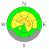
BOTTOM LINE
Danger by aspect and elevation on slopes approaching 35° or steeper.
(click HERE for tomorrow's danger rating)
|

Danger Rose Tutorial
|
Heightened avalanche conditions exist, and there is a Level 2 or Moderate danger on drifted slopes in the Logan Zone. There are also pockets with a Level 3 danger, and you are likely to trigger wind slab avalanches and/or large cornice falls if you travel on steep drifted slopes or ridge-tops, mainly in upper elevation terrain. Persistent wind slab avalanches up to a couple feet deep and failing on a poor bond with week-old dusty snow are possible in places... Triggered deep slab avalanches are unlikely but possible in isolated areas with a poor snow structure and/or a shallower slab layer, and could be triggered by overrunning snow from wind slab avalanches or cornice falls. Continue to use safe travel protocols and evaluate the snow and terrain carefully. |
|
|
CURRENT CONDITIONS |

|
You'll find pretty nice spring powder riding conditions, especially at upper elevations where the fresh snow is rimed and graupelly. Recent warmth and rain smoothed out the snow at mid and lower elevations, and cold temperatures Thursday night solidified the wet snow underlying a few inches of fresher powder from Wednesday... Fast snow yesterday allowed for great riding, especially on lower angled slopes... The Tony Grove Snotel reports 30 degrees and 120 inches of total snow with 141% of average water content for the date. It's 25degrees at the CSI weather station on Logan Peak at 9700'. South winds picked up overnight, and Mt. Ogden reports 45 mph average wind speeds this morning and gusts in the 60s.... |
|
|
RECENT ACTIVITY |

|
Most of the recent local action is in the Central Bear River Range. An observer reports "several" fresh rider triggered wind slabs in the Tony Grove Area yesterday, and he submitted a photo of a fairly broad soft slab north of Naomi Peak in the Bullen Basin Area of upper White Pine Canyon... The avalanche on a north facing slope at around 9500' in elevation looked to be a couple hundred feet wide and was reported to be around 20 inches deep... Another report of maybe two connected triggered wind slabs, from Thursday west of Tony Grove Lake.... The 18 inch deep by 150 foot wide wind slab avalanche(s) occurred on an east-northeast facing slope at around 9300' in elevation and involved freshly wind deposited snow from this week, likely failing on the old-new snow interface or last weekend's dusty snow surface...
.See our avalanche list HERE
|
|
|
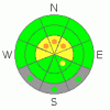
THREAT #1 |

|
| WHERE |
PROBABILITY |
SIZE |
TREND |
|
|
|
|
| |
|
|
Over the next
24 hours.
|
|
|
South winds picked up overnight and are likely to sustain and gain strength today. The wind will find plenty of somewhat heavy snow to drift about and it will build stiff wind slabs in lee terrain and deceleration zones or deposition areas... The danger of wind slab avalanches will likely become more widespread today, but will probably be limited to upper elevations where substantially more snow accumulated with Wednesday's warm and wet storm. Additional wind loading may activate existing wind slabs, and you still might trigger one-to-two-foot deep persistent wind slabs, failing on the interface of dusty snow that was on the surface last weekend, on some steep drifted upper elevation slopes, mainly in the Central Bear River Range. |
|
|
THREAT #2 |

|
| WHERE |
PROBABILITY |
SIZE |
TREND |
|
|
|
|
| |
|
|
Over the next
12 hours.
|
|
|
Continue to avoid and stay out from under the huge overhanging cornices on the major ridge lines, which often break further back than expected and could trigger avalanches on steep slopes below. Natural cornice falls are possible, especially while drifting is in progress... |
|
|
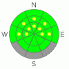
THREAT #3 |

|
| WHERE |
PROBABILITY |
SIZE |
TREND |
|
|
|
|
| |
|
|
Over the next
24 hours.
|
|
|
Dangerous triggered deep slab avalanches, failing on deeply buried weak layers are rather unlikely but still possible on steep slopes in some areas.. Wednesday's additional added weight from rain, heavy snow, and strong winds, as well as more drifting today, keep this threat alive. Overrunning snow from cornice falls or fresh wind slab avalanches could trigger dangerous deep slab avalanches on isolated steep slopes below. |
|
|
MOUNTAIN WEATHER |

|
The next spring storm system will push into the area today and we can expect intensifying and strong southwest winds. Expect some snowfall today, mainly in the afternoon, but with little accumulation. High temperatures should stay below freezing and cloud cover will hopefully keep things on the cool side today... A couple inches could accumulate at upper elevations overnight tonight. Expect similar weather for the next several days..... |
|
|
GENERAL ANNOUNCEMENTS |
We are offering a free avalanche awareness talk for riders on Thursday, March 24 at 6:00 at Renegade Sports in Nibley. This will be followed by a ride into avalanche terrain (field session) on Saturday, March 26.....
You can view a photo summary of last year's avalanche activity in the Logan Area HERE
Join the friends of the Utah Avalanche Center in Logan on facebook. Click HERE
I will update this advisory in the mornings on Mondays, Wednesdays, Fridays, and Saturdays, and on other days if backcountry avalanche conditions warrant...
You have the opportunity to participate in the creation of our own community avalanche advisory by submitting avalanche and snow observations. You can also call us at 801-524-5304 or Toby at 435-757-7578, or email by clicking HERE
Donate to your favorite non-profit – The Friends of the Utah Avalanche Center. The UAC depends on contributions from users like you to support our work.
This advisory is from the U.S.D.A. Forest Service, which is solely responsible for its content. This advisory describes general avalanche conditions and local variations always occur. |
|
|
This information does not apply to developed ski areas or highways where avalanche control is normally done. This advisory is from the U.S.D.A. Forest Service, which is solely responsible for its content. This advisory describes general avalanche conditions and local variations always occur. |
|
This advisory provided by the USDA Forest Service, in partnership with:
The Friends of the Utah Avalanche Center, Utah Division of State Parks and Recreation, Utah Division of Emergency Management, Salt Lake County, Salt Lake Unified Fire Authority and the friends of the La Sal Avalanche Center. See our Sponsors Page for a complete list. |
