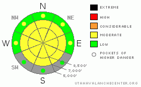
BOTTOM LINE
Danger by aspect and elevation on slopes approaching 35° or steeper.
(click HERE for tomorrow's danger rating)
|
Danger Rose Tutorial
|
Heightened avalanche conditions exist, and there is a Level 2 or Moderate danger on many slopes in the Logan Zone. You could trigger wind slab avalanches and/or large cornice falls on steep drifted slopes in upper elevation terrain. Wet avalanches could entrain significant snow and are possible on steep slopes with sun-warmed and saturated fresh snow up high and rain-soaked and softened snow down lower. .. Triggered deep slab avalanches are unlikely but possible in isolated areas with a poor snow structure and/or a shallower slab layer, and could be triggered by overrunning snow from wind slab avalanches, cornice falls, or wet avalanches. Continue to use safe travel protocols and evaluate the snow and terrain carefully. |
|
|
CURRENT CONDITIONS |

|
You'll find pretty nice spring powder riding conditions, especially at upper elevations. Recent warmth and rain smoothed out the underlying snow even in tracked areas.... Fast snow yesterday allowed for great riding on lower angled slopes... Springtime solar warming will likely be an issue in the backcountry today. The Tony Grove Snotel reports 17 degrees and 122 inches of total snow with 144% of average water content for the date It's 16 degrees at the CSI weather station on Logan Peak at 9700'. |
|
|
RECENT ACTIVITY |

|
An observer reports a rider triggered wind slab, or maybe two adjacent slabs, from yesterday west of Tony Grove Lake.... The 18 inch deep by 150 foot wide wind slab avalanche(s) occurred on an east-northeast facing slope at around 9300' in elevation and involved freshly wind deposited snow from this week, likely failing on the old-new snow interface or last weekend's dusty snow surface...
.See our avalanche list HERE
|
|
|
THREAT #1 |

|
| WHERE |
PROBABILITY |
SIZE |
TREND |
|
|
|
|
| |
|
|
Over the next
10 hours.
|
|
|
Although the danger is diminishing with settlement, you might still trigger one to two foot deep wind slabs from Wednesday's storm on some steep drifted upper elevation slopes.
Continue to avoid and stay out from under the huge overhanging cornices on the major ridge lines, which often break further back than expected and could trigger avalanches on steep slopes below. |
|
|
THREAT #2 |

|
| WHERE |
PROBABILITY |
SIZE |
TREND |

|
|
|
|
| |
|
|
Over the next
12 hours.
|
|
|
Wet avalanches are possible today, and most likely below around 8000' in elevation. Rain at mid and lower elevations Wednesday saturated the snow and added a bunch of new weight, while weakening snow structure.... Then several inches of fresh snow fell on some slopes and insulated the warm and wet slop.... Temperatures dropped significantly again overnight, which will help the situation, and cloud cover might help keep a lid on solar heating, but if the high angled sun peaks out for a bit, or seasonally common green-housing occurs, the danger of wet avalanches will rise with midday warming.. Loose wet avalanches or sluffs may entrain Wednesday's fresh storm snow and become significant especially in big terrain.... Be sure there is no one on a steep slope above you and be wary of trees, gullies, or other terrain traps below steep slopes.... |
|
|
THREAT #3 |

|
| WHERE |
PROBABILITY |
SIZE |
TREND |

|
|
|
|
| |
|
|
Over the next
24 hours.
|
|
|
Dangerous triggered deep slab avalanches, failing on deeply buried weak layers are rather unlikely but still possible on steep slopes in some areas.. Wednesday's additional added weight from rain, heavy snow, and strong winds, as well as seasonal solar warming today, keep this threat alive. Overrunning snow from cornice falls, fresh wind slabs, or wet sluffs could trigger dangerous deep slab avalanches on steep slopes below. |
|
|
MOUNTAIN WEATHER |

|
It'll be partly sunny and breezy, with high temperatures in the 30 degree range. Solar heating will certainly be a factor in sheltered terrain, likely affecting the fresh snow on sunny slopes. The next spring storm system will push into the area tomorrow and we can expect intensifying and strong southwest winds. Snowfall is likely throughout the weekend, but only a few inches of accumulation is forecast for each 12-hour period... |
|
|
GENERAL ANNOUNCEMENTS |
We are offering a free avalanche awareness talk for riders on Thursday, March 24 at 6:00 at Renegade Sports in Nibley. This will be followed by a ride into avalanche terrain (field session) on Saturday, March 26.....
You can view a photo summary of last year's avalanche activity in the Logan Area HERE
Join the friends of the Utah Avalanche Center in Logan on facebook. Click HERE
I will update this advisory in the mornings on Mondays, Wednesdays, Fridays, and Saturdays, and on other days if backcountry avalanche conditions warrant...
You have the opportunity to participate in the creation of our own community avalanche advisory by submitting avalanche and snow observations. You can also call us at 801-524-5304 or Toby at 435-757-7578, or email by clicking HERE
Donate to your favorite non-profit – The Friends of the Utah Avalanche Center. The UAC depends on contributions from users like you to support our work.
This advisory is from the U.S.D.A. Forest Service, which is solely responsible for its content. This advisory describes general avalanche conditions and local variations always occur. |
|
|
This information does not apply to developed ski areas or highways where avalanche control is normally done. This advisory is from the U.S.D.A. Forest Service, which is solely responsible for its content. This advisory describes general avalanche conditions and local variations always occur. |
|
This advisory provided by the USDA Forest Service, in partnership with:
The Friends of the Utah Avalanche Center, Utah Division of State Parks and Recreation, Utah Division of Emergency Management, Salt Lake County, Salt Lake Unified Fire Authority and the friends of the La Sal Avalanche Center. See our Sponsors Page for a complete list. |
