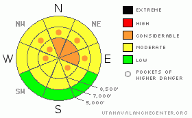
BOTTOM LINE
Danger by aspect and elevation on slopes approaching 35° or steeper.
(click HERE for tomorrow's danger rating)
|
Danger Rose Tutorial
|
The danger is level 3 or Considerable on drifted upper elevation slopes in the backcountry and dangerous avalanche conditions exist on many steep slopes. You are likely to trigger wind slabs and/or large cornice falls if you travel on steep slopes in upper elevation terrain exposed to drifting... Heightened avalanche conditions exist, and there is a Level 2 or Moderate danger on many other slopes in the zone. Wet avalanches could entrain significant fresh snow and are possible on slopes with saturated snow at all elevations... Dangerous triggered deep slab avalanches are possible in isolated areas with a poor snow structure and/or a shallower slab layer, and could be triggered by overrunning snow from wind slab avalanches,cornice fall or wet avalanches. Careful snowpack evaluation, cautious route finding, and conservative decision making are essential in avalanche terrain today. |
|
|
CURRENT CONDITIONS |

|
Rain fell up to around 8000' yesterday, and it turned the mid and lower elevation snow into slush... At higher elevations, south and west winds drifted heavy snow into sensitive wind slabs and built up the large overhanging cornices on exposed ridge lines. Temperatures dropped significantly overnight. The Tony Grove Snotel reports 17 degrees and 10 inches of new snow with 1.8 inches of water in the last 24 hours. It's a chilly 9 degrees at the CSI weather station on Logan Peak at 9700'. |
|
|
RECENT ACTIVITY |

|
We may well have remote triggered a nice wind slab from the ridge, or it may have been a small cornice chunk rolling low on an adjacent slope, or possibly a well timed natural release just before we got there... In any case, we found sensitive conditions yesterday, and the avalanche off the ridge west of Crescent Lake was around 1' deep and about150' wide on a north-northeast facing slope at around 9200'....
.See our avalanche list HERE
|
|
|
THREAT #1 |

|
| WHERE |
PROBABILITY |
SIZE |
TREND |

|
|
|
|
| |
|
|
Over the next
10 hours.
|
|
|
Southwest winds cranked all day yesterday, and we noticed significant drifting of heavy snow at upper elevations. Fresh snow from overnight may be obscuring yesterday's drifts, but you can expect to find stiffer wind slabs under a few inches of fresh snow as well as soft wind slabs within the storm snow... Yesterday we found that in some areas this week's fresh snow is not bonding well to the warm dusty snow that was on the snow surface last weekend... Continue to avoid and stay out from under the huge overhanging cornices on the major ridge lines, which often break further back than expected and could trigger avalanches on steep slopes below. |
|
|
THREAT #2 |

|
| WHERE |
PROBABILITY |
SIZE |
TREND |

|
|
|
|
| |
|
|
Over the next
12 hours.
|
|
|
Wet avalanches are possible today, and most likely below around 8000' in elevation. Rain at mid and lower elevations yesterday saturated the snow and added a bunch of new weight, while weakening snow structure.... Then several inches of fresh snow fell and insulated the warm and wet slop.... Temperatures dropped significantly overnight, which will help, and cloud cover will probably help keep a lid on solar heating, but you should be cautious of steep slopes with soft and saturated snow... If the high angled sun peaks out for a bit, or seasonally common green-housing occurs, the danger of wet avalanches will rise. Loose wet avalanches or sluffs may entrain fresh storm snow and become significant especially in big terrain.... Be sure there is no one on a steep slope above you and be wary of trees, gullies, or other terrain traps below steep slopes.... |
|
|
THREAT #3 |

|
| WHERE |
PROBABILITY |
SIZE |
TREND |

|
|
|
|
| |
|
|
Over the next
24 hours.
|
|
|
Natural cornice falls overrunning steep slopes below appear to have been the triggers of many recent hard slab avalanches in the region. Dangerous triggered deep slab avalanches, failing on deeply buried weak layers are rather unlikely but still possible on steep slopes in some areas.. Yesterday's additional added weight from rain, heavy snow, and strong winds keeps this threat alive. Overrunning snow from cornice falls, fresh wind slabs, or wet sluffs could trigger dangerous deep slab avalanches on steep slopes below. |
|
|
MOUNTAIN WEATHER |

|
It should stay fairly cool in the mountains with clouds and high temperatures in the lower 20s.... Overnight lows should be in the teens... Tomorrow will be mostly sunny and breezy with high temperatures in the 30 degree range, and solar heating will certainly be a factor affecting the fresh snow on sunny slopes. Looks cloudy over the weekend with mild temperatures, clouds, and some periods of snow..... |
|
|
GENERAL ANNOUNCEMENTS |
We are offering a free avalanche awareness talk for riders on Thursday, March 24 at 6:00 at Renegade Sports in Nibley. This will be followed by a ride into avalanche terrain (field session) on Saturday, March 26.....
You can view a photo summary of last year's avalanche activity in the Logan Area HERE
Join the friends of the Utah Avalanche Center in Logan on facebook. Click HERE
I will update this advisory in the mornings on Mondays, Wednesdays, Fridays, and Saturdays, and on other days if backcountry avalanche conditions warrant...
You have the opportunity to participate in the creation of our own community avalanche advisory by submitting avalanche and snow observations. You can also call us at 801-524-5304 or Toby at 435-757-7578, or email by clicking HERE
Donate to your favorite non-profit – The Friends of the Utah Avalanche Center. The UAC depends on contributions from users like you to support our work.
This advisory is from the U.S.D.A. Forest Service, which is solely responsible for its content. This advisory describes general avalanche conditions and local variations always occur. |
|
|
This information does not apply to developed ski areas or highways where avalanche control is normally done. This advisory is from the U.S.D.A. Forest Service, which is solely responsible for its content. This advisory describes general avalanche conditions and local variations always occur. |
|
This advisory provided by the USDA Forest Service, in partnership with:
The Friends of the Utah Avalanche Center, Utah Division of State Parks and Recreation, Utah Division of Emergency Management, Salt Lake County, Salt Lake Unified Fire Authority and the friends of the La Sal Avalanche Center. See our Sponsors Page for a complete list. |
