BOTTOM LINE
Danger by aspect and elevation on slopes approaching 35° or steeper.
(click HERE for tomorrow's danger rating)
|
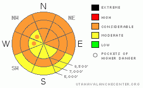
Danger Rose Tutorial
|
The avalanche will continue to rise overnight with more snow and continued wind in the mountains... The danger climbed to level 3 or Considerable this afternoon, and dangerous avalanche conditions exist on many steep slopes. Loose wet avalanches could entrain significant fresh snow and are possible at all elevations... You could trigger wind slabs and/or large cornice falls in upper elevation terrain exposed to drifting, and the danger will likely become more widespread throughout the day. Very dangerous triggered deep slab avalanches are possible in isolated areas with a poor snow structure and/or a shallower slab layer, and could be triggered by overrunning snow from wind slab avalanches or cornice fall. Natural avalanche activity is possible overnight tonight. Avoid and stay out from under steep slopes with rain saturated or drifted new snow...... |
|
|
CURRENT CONDITIONS |

|
You'll find damp snow on most slopes today and some could get downright wet with rain this morning. Temperatures are slowly falling from 40 degrees early this morning at the Tony Grove Snotel at 8400', and the station reports a still very warm, 36 degrees currently. There's 114 inches of total snow, and the station sits at 140% of normal water content for the date. The Hwy 89 Logan Summit weather station recorded west winds averaging over 30 mph with 40 mph gusts at 5:00 A.M.. |
|
|
RECENT ACTIVITY |

|
Looks like it was a fairly widespread natural hard slab cycle, at least in the Wellsvilles and Southern Bear River Range, with most impressive slab activity late last week due to more snow, strong southwest winds, and the rapid rise in temperatures... Monday's new snow was active yesterday, with triggered and natural loose wet sluffs and pinwheels on steep mid and upper elevation slopes......
.See our avalanche list HERE
|
|
|
THREAT #1 |

|
| WHERE |
PROBABILITY |
SIZE |
TREND |

|
|
|
|
| |
|
|
Over the next
10 hours.
|
|
|
Today's storm and the associated cold front this afternoon should drop temperatures from this morning's highs, and this will probably help with the wet avalanche threat . Likely starting as rain even up pretty high this morning, today's new snow will be wet, heavy, and prone to wet avalanching. Loose wet avalanches may entrain fresh storm snow and a few inches from earlier in the week and become significant.... Be sure there is no one on a steep slope above you and be wary of trees, gullies, or other terrain traps below steep slopes.... |
|
|
THREAT #2 |

|
| WHERE |
PROBABILITY |
SIZE |
TREND |
|
|
|
|
| |
|
|
Over the next
24 hours.
|
|
|
Southwest winds cranked it up a notch overnight, and we noticed drifting yesterday despite the rather heavy fresh snow. The winds will continue and perhaps intensify until the front passes, and wind slab avalanches consisting of drifted heavy snow are possible in exposed upper elevation terrain.
Continue to avoid and stay out from under the huge overhanging cornices on the major ridge lines, which often break further back than expected and could trigger avalanches on steep slopes below. Strong southwest winds and snowfall today will continue to build out these monsters, while rain and warming temperatures continue to cause them to soften, sag, buckle, and in some cases, fail. |
|
|
THREAT #3 |

|
| WHERE |
PROBABILITY |
SIZE |
TREND |
|
|
|
|
| |
|
|
Over the next
24 hours.
|
|
|
Natural cornice falls overrunning steep slopes below appear to have been the triggers of many recent hard slab avalanches in the region. Dangerous triggered deep slab avalanches, failing on deeply buried weak layers are rather unlikely but still possible on steep slopes in some areas.. Today's warm rain, heavy snow, and strong winds will keep this threat alive. Overrunning snow from cornice falls, fresh wind slabs, or wet sluffs could trigger dangerous deep slab avalanches on steep slopes below. |
|
|
MOUNTAIN WEATHER |

|
Expect snow and dropping temperatures at upper elevations, with 4 to 8 inches forecast for today and 5 to 9 tonight.... Some lightning is possible around the evening frontal passage... Winds will remain fairly strong out of the southwest at upper elevations today and will swing around from the northwest with frontal passage early tonight... Snowfall should tapper off tomorrow and we can expect cooler temperatures with 22 degrees forecast for 8500' and diminishing wind... More stormy weather is expected for the coming weekend.... |
|
|
GENERAL ANNOUNCEMENTS |
We are offering a free avalanche awareness talk for riders on Thursday, March 24 at 6:00 at Renegade Sports in Nibley. This will be followed by a ride into avalanche terrain (field session) on Saturday, March 26.....
You can view a photo summary of last year's avalanche activity in the Logan Area HERE
Join the friends of the Utah Avalanche Center in Logan on facebook. Click HERE
I will update this advisory in the mornings on Mondays, Wednesdays, Fridays, and Saturdays, and on other days if backcountry avalanche conditions warrant...
You have the opportunity to participate in the creation of our own community avalanche advisory by submitting avalanche and snow observations. You can also call us at 801-524-5304 or Toby at 435-757-7578, or email by clicking HERE
Donate to your favorite non-profit – The Friends of the Utah Avalanche Center. The UAC depends on contributions from users like you to support our work.
This advisory is from the U.S.D.A. Forest Service, which is solely responsible for its content. This advisory describes general avalanche conditions and local variations always occur. |
|
|
This information does not apply to developed ski areas or highways where avalanche control is normally done. This advisory is from the U.S.D.A. Forest Service, which is solely responsible for its content. This advisory describes general avalanche conditions and local variations always occur. |
|
This advisory provided by the USDA Forest Service, in partnership with:
The Friends of the Utah Avalanche Center, Utah Division of State Parks and Recreation, Utah Division of Emergency Management, Salt Lake County, Salt Lake Unified Fire Authority and the friends of the La Sal Avalanche Center. See our Sponsors Page for a complete list. |
