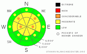
BOTTOM LINE
Danger by aspect and elevation on slopes approaching 35° or steeper.
(click HERE for tomorrow's danger rating)
|
Danger Rose Tutorial
|
There is a level 2 or Moderate danger in the backcountry, and heightened avalanche conditions exist in many areas. Warm temperatures over the weekend kept the deep slab threat alive, and several natural large hard slab avalanches were observed in the past few days in the Bear River Range south of Logan Canyon and in the Wellsville Range... There are pockets of level 3 or Considerable danger, and dangerous triggered deep slab avalanches are possible in areas with a poor snow structure and/or a shallower slab layer, and could be triggered by overrunning snow from wind slab avalanches or cornice fall. Avoid and stay out from under large overhanging cornices along the ridgetops, which might break further back than expected.. Cooling and cloud cover should harden the saturated lower and mid-elevation snow, but wet avalanches will still be possible today, and the danger will rise with midday warming, especially if the powerful sun peaks out for a while... Continue to use safe travel protocols and evaluate the snow and terrain carefully. |
|
|
CURRENT CONDITIONS |

|
You'll find crusty and damp snow on most slopes, in some cases pleasantly supportable... You could find lingering stashes of settled powder, mainly at upper elevations and on north facing slopes.... The Tony Grove Snotel at 8400' reports a very warm, 35 degrees this morning and 113 inches of total snow. The station sits at 141% of normal water content for the date. It's 28 degrees at 9700' as recorded by the CSI Logan Peak weather station... |
|
|
RECENT ACTIVITY |

|
The rapid warm-up caused many natural avalanches locally. Yesterday afternoon, I and many of you could clearly see evidence of a fresh natural deep slab avalanche off the Southwest Shoulder of Big Baldy above Providence. Large recent natural avalanches were also observed up in Dry Canyon late Friday.... On Friday morning, we could see evidence of several recent large natural hard slab avalanches up in the Wellsville Mountain Wilderness... I'm not sure about the exact timing of any of these dangerous avalanches, but I'm thinking the initial and rapid spring warm-up is the cause. The heat probably both softened the hard slab layer, and caused significantly increased creep rates. Overrunning cornice fall probably triggered some of them....
A snowboarder triggered a stiff wind slab avalanche west of Tony Grove Lake on Thursday. The avalanche on a drifted north facing slope at around 9200' was reported to be around 40 feet wide and around a foot deep...
.See our avalanche list HERE
|
|
|
THREAT #1 |

|
| WHERE |
PROBABILITY |
SIZE |
TREND |

|
|
|
|
| |
|
|
Over the next
24 hours.
|
|
|
Dangerous triggered deep slab avalanches, failing on now deeply buried January weak layers are possible in some areas, more so with last week's load of new snow and wind drifting, and the rapidly warming temperatures over the weekend. Overrunning snow from cornice falls or fresh wind slabs could trigger dangerous deep slab avalanches on steep slopes below. The seasonally warming temperatures are likely softening the existing hard slabs, which may allow for human triggering in some cases..... |
|
|
THREAT #2 |

|
| WHERE |
PROBABILITY |
SIZE |
TREND |
|
|
|
|
| |
|
|
Over the next
24
hours.
|
|
|
Wind slab avalanches consisting of drifted fresh snow are possible Tuesday in upper elevation terrain exposed to wind. Continue to avoid and stay well away from and out from under the huge overhanging cornices on the major ridge lines, which often break further back than expected and are likely to trigger avalanches on steep slopes below. Strong winds last week continued to build these monsters while recent warming temperatures caused them to soften, sag, buckle, and in some cases, fail. |
|
|
THREAT #3 |

|
| WHERE |
PROBABILITY |
SIZE |
TREND |

|
|
|
|
| |
|
|
Over the next
10 hours.
|
|
|
Cloud cover and dropping temperatures will likely help to keep this problem mostly under control today. Cloud cover trapped heat in the atmosphere and overnight temperatures did not drop very far below freezing even at higher elevations, but today's brush-by storm and the associated cold front should drop temperatures from this morning's highs. The cooling should harden up soft isothermal snow on sunny slopes at lower and mid elevations... Wet avalanches will be most likely on steep slopes with soft saturated snow, and with today's cloud cover, mainly on shady low and mid-elevation slopes.... |
|
|
MOUNTAIN WEATHER |

|
The moist westerly flow will continue, with cooling temperatures, cloud cover, and a chance for a few inches of snow today. Another, slightly stronger storm will affect the zone Tuesday night and Wednesday, with several more inches of accumulation forecast.... |
|
|
GENERAL ANNOUNCEMENTS |
We are offering a free avalanche awareness talk for riders on Thursday, March 24 at 6:00 at Renegade Sports in Nibley. This will be followed by a ride into avalanche terrain (field session) on Saturday, March 26.....
You can view a photo summary of last year's avalanche activity in the Logan Area HERE
Join the friends of the Utah Avalanche Center in Logan on facebook. Click HERE
I will update this advisory in the mornings on Mondays, Wednesdays, Fridays, and Saturdays, and on other days if backcountry avalanche conditions warrant...
You have the opportunity to participate in the creation of our own community avalanche advisory by submitting avalanche and snow observations. You can also call us at 801-524-5304 or Toby at 435-757-7578, or email by clicking HERE
Donate to your favorite non-profit – The Friends of the Utah Avalanche Center. The UAC depends on contributions from users like you to support our work.
This advisory is from the U.S.D.A. Forest Service, which is solely responsible for its content. This advisory describes general avalanche conditions and local variations always occur. |
|
|
This information does not apply to developed ski areas or highways where avalanche control is normally done. This advisory is from the U.S.D.A. Forest Service, which is solely responsible for its content. This advisory describes general avalanche conditions and local variations always occur. |
|
This advisory provided by the USDA Forest Service, in partnership with:
The Friends of the Utah Avalanche Center, Utah Division of State Parks and Recreation, Utah Division of Emergency Management, Salt Lake County, Salt Lake Unified Fire Authority and the friends of the La Sal Avalanche Center. See our Sponsors Page for a complete list. |
