BOTTOM LINE
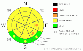
Danger by aspect and elevation on slopes approaching 35° or steeper.
(click HERE for tomorrow's danger rating)
|
Danger Rose Tutorial
|
There is a level 2 or Moderate danger in the backcountry, and heightened avalanche conditions exist in many areas. Avoid and stay out from under large overhanging cornices on the ridgetops, which might break further back than expected.. You could trigger stiff wind slabs on some drifted upper elevation slopes steeper than about 35 degrees. Dangerous triggered deep slab avalanches are still possible in areas with a poor snow structure and/or a shallower slab layer, and could be triggered by overrunning snow from wind slabs or cornice fall. The danger of wet avalanches will rise with midday warming... Recent natural activity indicates that there may be a level 3 danger on mostly east facing slopes in the Wellsville Range....... Continue to use safe travel protocols and evaluate the snow and terrain carefully. |
|
|
CURRENT CONDITIONS |

|
I found several inches of new somewhat heavy and very dusty snow at upper elevations in the Central Bear River Range yesterday. Trail breaking was difficult at times, and at one point I was plowing a pile of moist dust-gray snowballs bigger than my sled. I had to stop and knock it down just so I could ride over it. The Tony Grove Snotel at 8400' reports a warm, 27 degrees this morning and 117 inches of total snow. The station sits at 143% of normal water content for the date. |
|
|
RECENT ACTIVITY |

|
The rapid warm-up Thursday caused many natural loose wet avalanches locally. Yesterday morning, we could see evidence of several recent large natural hard slab avalanches up in the Wellsville Mountain Wilderness... I'm not sure about the timing of these, but some looked fresh enough to have occurred on Thursday... Looked like overrunning cornice fall probably triggered some of them....An observer noted a fresh natural wind slab avalanche near the ridgetop in south Wood Camp.... A snowboarder triggered a stiff wind slab avalanche west of Tony Grove Lake on Thursday. The avalanche on a drifted north facing slope at around 9200' was reported to be around 40 feet wide and around a foot deep...
.See our avalanche list HERE
|
|
|
THREAT #1 |

|
| WHERE |
PROBABILITY |
SIZE |
TREND |

|
|
|
|
| |
|
|
Over the next
24 hours.
|
|
|
Continue to avoid and stay well away from and out from under the huge overhanging cornices on the major ridge lines, which often break further back than expected and are likely to trigger avalanches on steep slopes below. Strong winds this week continued to build these monsters while recent warming temperatures caused them to soften, sag, and buckle.
You could trigger stiff wind slab avalanches 1 to 2 feet deep on steep drifted slopes mainly at upper elevations. Some of the wind slabs from earlier in the week built on lighter density colder snow and in some cases, a thin frosty weak layer or surface hoar. Watch for and avoid drifted stiffer snow on steep slopes on the lee sides of ridges and around terrain features like under cliff bands, gullies, roll-offs, or scoops. |
|
|
THREAT #2 |

|
| WHERE |
PROBABILITY |
SIZE |
TREND |

|
|
|
|
| |
|
|
Over the next
24
hours.
|
|
|
Dangerous triggered deep slab avalanches, failing on now deeply buried January weak layers are possible in some areas, more so with the recent load of new snow, wind drifting, and rapidly warming temperatures. Overrunning snow from cornice falls or fresh wind slabs triggered several of the most recent natural hard slabs in the zone, and this scenario is possible again this weekend. The seasonally warming temperatures are likely softening the existing hard slabs, which may allow for human triggering in some cases..... |
|
|
THREAT #3 |

|
| WHERE |
PROBABILITY |
SIZE |
TREND |

|
|
|
|
| |
|
|
Over the next
10 hours.
|
|
|
Cloud cover will likely help to keep this problem mostly under control today. Despite fairly warm mountain temperatures, overnight cooling caused a only shallow refreeze of the moist surface snow, and seasonal midday warming and potential green-housing today will again cause the saturated surface snow to soften and become prone to wet avalanche... Wet avalanches will be most likely on steep slopes with soft saturated snow, mainly shady low and mid-elevation slopes. |
|
|
MOUNTAIN WEATHER |

|
The moist westerly flow will continue, with cloud cover and a chance for snow showers today. Expect fairly mild temperatures, with conditions perfect for green-housing if the powerful spring sun peaks out through the heat trapping clouds..... We'll see some snow in the mountains this evening, and 1 or 2 inches of accumulation is forecast.... Looks like the zonal weather pattern will continue through the weekend and into next week, with warmer temperatures and more sun on Sunday and periods of snowfall, although not much accumulation is expected... |
|
|
GENERAL ANNOUNCEMENTS |
We are offering a free avalanche awareness talk for riders on Thursday, March 24 at 6:00 at Renegade Sports in Nibley. This will be followed by a ride into avalanche terrain (field session) on Saturday, March 26.....
You can view a photo summary of last year's avalanche activity in the Logan Area HERE
Join the friends of the Utah Avalanche Center in Logan on facebook. Click HERE
I will update this advisory in the mornings on Mondays, Wednesdays, Fridays, and Saturdays, and on other days if backcountry avalanche conditions warrant...
You have the opportunity to participate in the creation of our own community avalanche advisory by submitting avalanche and snow observations. You can also call us at 801-524-5304 or Toby at 435-757-7578, or email by clicking HERE
Donate to your favorite non-profit – The Friends of the Utah Avalanche Center. The UAC depends on contributions from users like you to support our work.
This advisory is from the U.S.D.A. Forest Service, which is solely responsible for its content. This advisory describes general avalanche conditions and local variations always occur. |
|
|
This information does not apply to developed ski areas or highways where avalanche control is normally done. This advisory is from the U.S.D.A. Forest Service, which is solely responsible for its content. This advisory describes general avalanche conditions and local variations always occur. |
|
This advisory provided by the USDA Forest Service, in partnership with:
The Friends of the Utah Avalanche Center, Utah Division of State Parks and Recreation, Utah Division of Emergency Management, Salt Lake County, Salt Lake Unified Fire Authority and the friends of the La Sal Avalanche Center. See our Sponsors Page for a complete list. |
