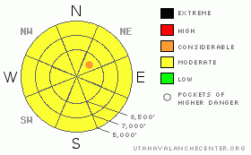
BOTTOM LINE
Danger by aspect and elevation on slopes approaching 35° or steeper.
(click HERE for tomorrow's danger rating)
|
Danger Rose Tutorial
|
There is a Level 2 or Moderate danger in the backcountry. Heightened avalanche conditions exist, and you could trigger fresh or stiffer wind slabs and/or cornice falls in terrain exposed to wind drifting.. Dangerous triggered deep slab avalanches are possible in areas with a poor snow structure and/or a shallower slab layer, and could be triggered by overrunning snow from wind slabs or cornice fall. The danger of wet avalanches involving the fresh snow could rise with midday warming, especially if powerful spring sunshine breaks through the cloud cover. Continue to use safe travel protocols and evaluate the snow and terrain carefully. |
|
|
CURRENT CONDITIONS |

|
You'll find fairly deep, somewhat heavy and slow powder conditions in the backcountry today. Lower elevations picked up a bit less but heavier snow The Bear River Range received a few more inches of new snow yesterday and overnight, and west and northwest winds picked up for several hours last night. The Hwy89 Logan Summit wind sensor recorded 20mph hourly average wind speeds with gusts up around 30mph. The Tony Grove Snotel at 8400' reports 24 degrees this morning, and several inches of somewhat heavy new snow with 7/10ths of an inch of water in the last 24 hrs. There's now 125 inches of total snow on the ground and the station sits at 145% of normal water content for the date. |
|
|
RECENT ACTIVITY |

|
There was a fairly widespread natural cycle involving new snow and shallow wind slab avalanches in the Logan Zone, but so far no deep slab releases were observed in the area since last week....A large and scary natural deep slab was reported from the Ogden Area backcountry near Powder Mountain on Monday... A new wind slab avalanche overran a slope with a deeply buried weak layer, which failed a bit above the mid January rain-crust. The avalanche was reported to be 4+' deep, around 500' wide, and it ran around 2500 vrt'. A skier remote triggered a scary and broad hard slab avalanche in the far western Uinta Range yesterday, the second such event this week in that area.....
.See our avalanche list HERE
|
|
|
THREAT #1 |

|
| WHERE |
PROBABILITY |
SIZE |
TREND |
|
|
|
|
| |
|
|
Over the next
24 hours.
|
|
|
West and northwest winds picked up again for several hours overnight building drifts and wind slabs with fresh snow in exposed terrain... You'll still need to watch for and avoid drifted snow on steep slopes on the lee sides of ridges and in terrain dictated deposition areas, and be very cautious when traveling in exposed terrain above trees, gullies, benches or other terrain traps...
Avoid and stay well away from the huge overhanging cornices on the major ridge lines, which are likely to break further back than expected and might trigger avalanches on steep slopes below. |
|
|
THREAT #2 |

|
| WHERE |
PROBABILITY |
SIZE |
TREND |

|
|
|
|
| |
|
|
Over the next
24
hours.
|
|
|
Dangerous triggered deep slab avalanches, failing on now deeply buried January weak layers are possible in some areas, more so with the recent load of new snow. Recent deep slab avalanches have occurred during significant loading events, with lots of rapidly applied weight from new snow and wind drifting. Overrunning snow from cornice falls or fresh wind slabs triggered several of the most recent natural hard slabs in the zone. |
|
|
THREAT #3 |

|
| WHERE |
PROBABILITY |
SIZE |
TREND |

|
|
|
|
| |
|
|
Over the next
10 hours.
|
|
|
Cloud cover will likely keep this problem under control today, but if the sun peaks out for even a little bit and midday temperatures rise, the already moist fresh snow will become prone to loose wet avalanches.... I'd expect the most threat at lower elevations, but you should avoid steep slopes with saturated surface snow and be wary of steep sided gullies and other potential terrain traps. |
|
|
MOUNTAIN WEATHER |

|
A westerly flow aloft is keeping Pacific moisture streaming into the region and we should see mostly cloudy conditions again today.... Mountain high temperatures should remain in the mid twenties, and a sustained moderate southwest wind will continue to drift snow in exposed terrain. Temperatures and winds will remain steady overnight tonight with around 24 degrees and west southwest winds in the teens. It'll warm up drastically in the mountains tomorrow with mostly sunny conditions forecast, so you should expect an increase in wet avalanche danger, especially on sunny slopes...... |
|
|
GENERAL ANNOUNCEMENTS |
We are offering a free avalanche awareness talk for riders on Thursday, March 24 at 6:00 at Renegade Sports in Nibley. This will be followed by a ride into avalanche terrain (field session) on Saturday, March 26.....
You can view a photo summary of last year's avalanche activity in the Logan Area HERE
Join the friends of the Utah Avalanche Center in Logan on facebook. Click HERE
I will update this advisory in the mornings on Mondays, Wednesdays, Fridays, and Saturdays, and on other days if backcountry avalanche conditions warrant...
You have the opportunity to participate in the creation of our own community avalanche advisory by submitting avalanche and snow observations. You can also call us at 801-524-5304 or Toby at 435-757-7578, or email by clicking HERE
Donate to your favorite non-profit – The Friends of the Utah Avalanche Center. The UAC depends on contributions from users like you to support our work.
This advisory is from the U.S.D.A. Forest Service, which is solely responsible for its content. This advisory describes general avalanche conditions and local variations always occur. |
|
|
This information does not apply to developed ski areas or highways where avalanche control is normally done. This advisory is from the U.S.D.A. Forest Service, which is solely responsible for its content. This advisory describes general avalanche conditions and local variations always occur. |
|
This advisory provided by the USDA Forest Service, in partnership with:
The Friends of the Utah Avalanche Center, Utah Division of State Parks and Recreation, Utah Division of Emergency Management, Salt Lake County, Salt Lake Unified Fire Authority and the friends of the La Sal Avalanche Center. See our Sponsors Page for a complete list. |
