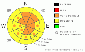
BOTTOM LINE
Danger by aspect and elevation on slopes approaching 35° or steeper.
(click HERE for tomorrow's danger rating)
|
Danger Rose Tutorial
|
There is a Level 3 or Considerable danger in the backcountry, and dangerous avalanche conditions exist. You could trigger sizable wind slabs and loose snow avalanches consisting of fresh storm snow on slopes steeper than about 35 degrees... Triggered fresh wind slabs and cornice falls are likely in exposed terrain today... Dangerous triggered deep slab avalanches are possible in areas with a poor snow structure and/or a shallower slab layer, and could be triggered by overrunning snow from wind slabs, storm snow avalanches or cornice fall. Careful snowpack evaluation, cautious route finding, and conservative decision are all essential if you're traveling in avalanche terrain today. |
|
|
CURRENT CONDITIONS |

|
The Bear River Range received several more inches of new snow yesterday and overnight, and west and northwest winds picked up for several hours around prime time. The Tony Grove Snotel at 8400' reports a cooler 16 degrees this morning, and around 4 inches of new snow with 4/10ths of an inch of water in the last 24 hrs. There's now 126 inches of total snow on the ground and the station sits at 144% of normal water content for the date. |
|
|
RECENT ACTIVITY |

|
There were a couple unintentionally triggered wind slab avalanches in the Central Wasatch Range yesterday, and a large and scary natural deep slab was reported from the Ogden Area backcountry near Powder Mountain... A new wind slab avalanche overran a slope with a deeply buried weak layer, which failed a bit above the mid January rain-crust. The avalanche was reported to be 4+' deep, around 500' wide, and it ran around 2500 vrt'. Locally, I received reports of triggered new snow avalanches in Providence Canyon and Tony Grove on Sunday, and I intentionally triggered sizable loose avalanches running on a sun-crust from late last week off the south ridge of Beaver Mountain on Sunday and a few sluffs involving all the fresh snow on steep north facing slopes in the Tony Grove Area. We noticed evidence of several small natural soft slabs and loose snow avalanches on the steep slopes around the lake.
.See our avalanche list HERE
|
|
|
THREAT #1 |

|
| WHERE |
PROBABILITY |
SIZE |
TREND |

|
|
|
|
| |
|
|
Over the next
12 hours.
|
|
|
West and northwest winds picked up for several hours overnight building drifts and wind slabs with fresh snow in exposed terrain... A few inches of powdery snow might now obscure wind slabs formed overnight. But you'll still need to watch for and avoid drifted snow on steep slopes on the lee sides of ridges and in terrain dictated deposition areas, and be very cautious when traveling in exposed terrain above trees, gullies, benches or other terrain traps...
Avoid and stay well away from the lips of huge overhanging cornices on the major ridge lines, which are likely to break further back than expected and might trigger avalanches on steep slopes below. |
|
|
THREAT #2 |

|
| WHERE |
PROBABILITY |
SIZE |
TREND |
|
|
|
|
| |
|
|
Over the next
24 hours.
|
|
|
Sizable, but soft triggered sluffs and soft slabs involving fresh snow will again be probable in steep terrain today.... Many of these will still be mostly manageable and will probably not pose a great threat to you unless you happen to be hit from above or are swept into trees or other terrain traps below....Some storm snow avalanches today could be broader than expected, or entrain more snow, and be fairly dangerous... Stay spread out and be sure no one is below or above you in steep terrain, and avoid steep slopes above gullies, sinks, or trees.... |
|
|
THREAT #3 |

|
| WHERE |
PROBABILITY |
SIZE |
TREND |
|
|
|
|
| |
|
|
Over the next
24 hours.
|
|
|
Dangerous triggered deep slab avalanches, failing on now deeply buried January weak layers are possible in some areas, more so with the recent load of new snow. Recent deep slab avalanches have occurred during significant loading events, with lots of rapidly applied weight from new snow and wind drifting. Overrunning snow from cornice falls or fresh wind slabs triggered several of the most recent natural hard slabs in the zone. |
|
|
MOUNTAIN WEATHER |

|
The action is winding down in our area this morning as the storm system slides eastward, and a high pressure system will begin to build over the region. We might get an inch or two of accumulation in the mountains this morning, but snowfall will tapper to showers and shut off later today. Mountain high temperatures will be in the upper teens and we'll feel a moderate west breeze. Expect mostly sunny weather in the mountains on Wednesday, with clouds building in and chance for a little snow again on Thursday and Thursday night. |
|
|
GENERAL ANNOUNCEMENTS |
We are offering a free avalanche awareness talk for riders on Thursday, March 24 at 6:00 at Renegade Sports in Nibley. This will be followed by a ride into avalanche terrain (field session) on Saturday, March 26.....
You can view a photo summary of last year's avalanche activity in the Logan Area HERE
Join the friends of the Utah Avalanche Center in Logan on facebook. Click HERE
I will update this advisory in the mornings on Mondays, Wednesdays, Fridays, and Saturdays, and on other days if backcountry avalanche conditions warrant...
You have the opportunity to participate in the creation of our own community avalanche advisory by submitting avalanche and snow observations. You can also call us at 801-524-5304 or Toby at 435-757-7578, or email by clicking HERE
Donate to your favorite non-profit – The Friends of the Utah Avalanche Center. The UAC depends on contributions from users like you to support our work.
This advisory is from the U.S.D.A. Forest Service, which is solely responsible for its content. This advisory describes general avalanche conditions and local variations always occur. |
|
|
This information does not apply to developed ski areas or highways where avalanche control is normally done. This advisory is from the U.S.D.A. Forest Service, which is solely responsible for its content. This advisory describes general avalanche conditions and local variations always occur. |
|
This advisory provided by the USDA Forest Service, in partnership with:
The Friends of the Utah Avalanche Center, Utah Division of State Parks and Recreation, Utah Division of Emergency Management, Salt Lake County, Salt Lake Unified Fire Authority and the friends of the La Sal Avalanche Center. See our Sponsors Page for a complete list. |
