BOTTOM LINE
Danger by aspect and elevation on slopes approaching 35° or steeper.
(click HERE for tomorrow's danger rating)
|
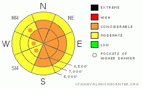
Danger Rose Tutorial
|
Heightened avalanche conditions exist on many slopes this morning, and there's a Level 2 or Moderate danger in the backcountry. You could trigger sizable loose avalanches and/or soft wind slabs consisting of fresh storm snow on slopes steeper than about 35 degrees... Increasing wind and resuming snowfall later this afternoon will cause a rising danger and could create more widespread dangerous avalanche conditions in exposed terrain... The storm will probably cause the danger level to rise to Level 3 or Considerable this afternoon, with triggered fresh wind slabs and cornice falls becoming more likely... Dangerous triggered deep slabs are generally unlikely and would most likely be difficult for you to trigger at this point, but they are still possible in areas with a poor snow structure and/or a shallower slab layer. Natural avalanches may occur overnight. Careful snowpack evaluation, cautious route finding, and conservative decision making will become essential in avalanche terrain today. |
|
|
CURRENT CONDITIONS |

|
Winds diminished yesterday evening and its been fairly calm overnight in the mountains. Yesterday's snow had a bit of an inversion, with slightly heavier snow falling mid-storm. Although not really heavy, the fresh snow had a moist spring-like or perhaps sub-tropical feel to it. The Tony Grove Snotel at 8400' reports 22 degrees this morning, and 11 inches of new snow on the total snow stake, with 1.5 inches of water. There's now 122 inches of total snow on the ground and the station sits at 144% of normal water content for the date. |
|
|
RECENT ACTIVITY |

|
Riders report triggering cornice falls and a ridge-top wind slab in drifted north facing terrain with resumed southwest winds in Providence Canyon Friday..... Significant but manageable and easily triggered loose snow sluffs and fresh soft slabs involving the fresh snow were reported from across the Northern Utah Mountains yesterday. Locally, I received reports of triggered new snow avalanches in Providence Canyon and Tony Grove, and yesterday afternoon I intentionally triggered sizable loose avalanches running on a sun-crust from late last week off the south ridge of Beaver Mountain
.See our avalanche list HERE
|
|
|
THREAT #1 |

|
| WHERE |
PROBABILITY |
SIZE |
TREND |

|
|
|
|
| |
|
|
Over the next
12 hours.
|
|
|
Sizable, but soft and manageable triggered sluffs and soft slabs involving fresh snow will again be probable in steep terrain today.... These will not pose a great threat to you unless you happen to be hit from above or are swept into trees or other terrain traps below.... Stay spread out and be sure no one is below or above you in steep terrain, and avoid steep slopes above gullies, sinks, or trees.... |
|
|
THREAT #2 |

|
| WHERE |
PROBABILITY |
SIZE |
TREND |
|
|
|
|
| |
|
|
Over the next
24 hours.
|
|
|
Increasing west and northwest winds this afternoon, evening, and overnight will rapidly build drifts and wind slabs with fresh snow in exposed terrain... Soft, freshly formed slabs can be quite sensitive, while stiffer wind slabs might be somewhat stubborn and can allow you to get out on them before breaking loose. Watch for and avoid drifted snow on steep slopes on the lee sides of ridges and in terrain dictated deposition areas, and be very cautious when traveling in exposed terrain above trees, gullies, benches or other terrain traps... As we get more snow and wind today, the danger of wind slab and storm snow avalanches will increase and become more widespread... Avoid and stay well away from the lips of huge overhanging cornices on the major ridge lines, which could break further back than expected and trigger avalanches on steep slopes below. |
|
|
THREAT #3 |

|
| WHERE |
PROBABILITY |
SIZE |
TREND |

|
|
|
|
| |
|
|
Over the next
24 hours.
|
|
|
Dangerous triggered deep slab avalanches, failing on now deeply buried January weak layers are generally unlikely but still possible in some areas, and the consequences of awakening one of these dragons could be deadly. Recent deep slab avalanches have occurred during significant loading events, with lots of rapidly applied weight from new snow and wind drifting. Overrunning snow from cornice falls triggered the most recent natural hard slabs in the zone. |
|
|
MOUNTAIN WEATHER |

|
The National Weather Service continued a Winter Storm Warning for the region. Expect snow and winds to resume this afternoon, with 3 to 5 inches forecast by evening. Winds tonight will be fairly sustained out of the west and northwest, with gusts of around 40 mph possible, and 3 to 7 additional inches of accumulation forecast. The action will wind down in our area tomorrow, and a high pressure system will begin to build. Expect mostly sunny weather in the mountains on Wednesday. |
|
|
GENERAL ANNOUNCEMENTS |
We are offering a free avalanche awareness talk for riders on Thursday, March 24 at 6:00 at Renegade Sports in Nibley. This will be followed by a ride into avalanche terrain (field session) on Saturday, March 26.....
You can view a photo summary of last year's avalanche activity in the Logan Area HERE
Join the friends of the Utah Avalanche Center in Logan on facebook. Click HERE
I will update this advisory in the mornings on Mondays, Wednesdays, Fridays, and Saturdays, and on other days if backcountry avalanche conditions warrant...
You have the opportunity to participate in the creation of our own community avalanche advisory by submitting avalanche and snow observations. You can also call us at 801-524-5304 or Toby at 435-757-7578, or email by clicking HERE
Donate to your favorite non-profit – The Friends of the Utah Avalanche Center. The UAC depends on contributions from users like you to support our work.
This advisory is from the U.S.D.A. Forest Service, which is solely responsible for its content. This advisory describes general avalanche conditions and local variations always occur. |
|
|
This information does not apply to developed ski areas or highways where avalanche control is normally done. This advisory is from the U.S.D.A. Forest Service, which is solely responsible for its content. This advisory describes general avalanche conditions and local variations always occur. |
|
This advisory provided by the USDA Forest Service, in partnership with:
The Friends of the Utah Avalanche Center, Utah Division of State Parks and Recreation, Utah Division of Emergency Management, Salt Lake County, Salt Lake Unified Fire Authority and the friends of the La Sal Avalanche Center. See our Sponsors Page for a complete list. |
