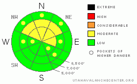
BOTTOM LINE
Danger by aspect and elevation on slopes approaching 35° or steeper.
(click HERE for tomorrow's danger rating)
|
Danger Rose Tutorial
|
The danger is Level 1 or Low on the majority of slopes in the Logan Zone, and the snow appears generally stable in most areas. However, heightened avalanche conditions exist in drifted terrain, and there's a Level 2 or Moderate danger on upper and some mid-elevation slopes facing northwest through east. You could trigger stiff and building wind slabs on steep drifted slopes, and large overhanging cornices could break further back than expected or calve off above you as winds continue to build them out over space. Dangerous triggered deep slabs are generally unlikely and would most likely be difficult for you to trigger at this point, but they are still possible in areas with a poor snow structure and/or a shallower slab layer. Continue to use safe travel protocols and evaluate the snow and terrain carefully. |
|
|
CURRENT CONDITIONS |

|
More snow fell Thursday at upper elevations and in the Southern Bear River Range, but conditions across the zone certainly improved. You'll find the best powder riding in sheltered shady terrain, but many areas offer good quality options... Solar heating yesterday crusted up slopes that were exposed to prolonged sun. The Tony Grove Snotel at 8400' reports 26 degrees, and with 114 inches of total snow on the ground the station sits at 142% of normal water content for the date. |
|
|
RECENT ACTIVITY |

|
Strong winds Sunday night and Monday caused several large natural cornice falls, some of which triggered wind slab and even a few deep slab avalanches on steep slopes below. Numerous natural but no triggered avalanches were reported in the Logan Zone in the last week....
.See our avalanche list HERE
|
|
|
THREAT #1 |

|
| WHERE |
PROBABILITY |
SIZE |
TREND |

|
|
|
|
| |
|
|
Over the next
24 hours.
|
|
|
Increasing southwest winds will build fresh drifts and wind slabs with Thursday's fresh snow in exposed terrain... Stiff and building wind slabs might be somewhat stubborn, and harder wind slabs can allow you to get out on them before breaking loose. Watch for and avoid drifted snow on steep slopes on the lee sides of ridges and in terrain dictated deposition areas, and be very cautious when traveling in exposed terrain above trees, gullies, benches or other terrain traps... |
|
|
THREAT #2 |

|
| WHERE |
PROBABILITY |
SIZE |
TREND |
|
|
|
|
| |
|
|
Over the next
24 hours.
|
|
|
The cornices are truly huge this winter in some places, and some are quite menacing and evil looking.... These overhanging monsters on the major ridgelines are dangerous because you can't see them when you get out on them and they might break under your weight much further back than expected.... These large cornices also become quite dangerous to travel under, especially as they are building in windy conditions, since large chunks might naturally break off at any time and careen down on you or trigger avalanches on slopes below.... |
|
|
THREAT #3 |

|
| WHERE |
PROBABILITY |
SIZE |
TREND |
|
|
|
|
| |
|
|
Over the next
24
hours.
|
|
|
Dangerous triggered deep slab avalanches, failing on now deeply buried January weak layers are generally unlikely but still possible in some areas, and the consequences of awakening one of these dragons could be deadly. Recent deep slab avalanches have occurred during significant loading events, with lots of rapidly applied weight from new snow and wind drifting. Overrunning snow from cornice falls triggered the most recent natural hard slabs in the zone. |
|
|
MOUNTAIN WEATHER |

|
The National Weather Service has issued a Winter Storm Watch for our region beginning Sunday morning and extending through Monday, as a moist and potent looking storm moves out of the Gulf of Alaska and into the northwest. Expect increasing clouds, intensifying southwest winds, and fairly moderate temperatures in the mountains today ahead of a the approaching storm. 7 to 13 inches of accumulation is expected tonight and tomorrow before a brief break in the action Sunday night. Significant accumulations are possible Monday, with the storm continuing though tapering off Tuesday.... |
|
|
GENERAL ANNOUNCEMENTS |
We are offering a free avalanche awareness talk for riders on Thursday, March 24 at 6:00 at Renegade Sports in Nibley. This will be followed by a ride into avalanche terrain (field session) on Saturday, March 26.....
You can view a photo summary of last year's avalanche activity in the Logan Area HERE
Join the friends of the Utah Avalanche Center in Logan on facebook. Click HERE
I will update this advisory in the mornings on Mondays, Wednesdays, Fridays, and Saturdays, and on other days if backcountry avalanche conditions warrant...
You have the opportunity to participate in the creation of our own community avalanche advisory by submitting avalanche and snow observations. You can also call us at 801-524-5304 or Toby at 435-757-7578, or email by clicking HERE
Donate to your favorite non-profit – The Friends of the Utah Avalanche Center. The UAC depends on contributions from users like you to support our work.
This advisory is from the U.S.D.A. Forest Service, which is solely responsible for its content. This advisory describes general avalanche conditions and local variations always occur. |
|
|
This information does not apply to developed ski areas or highways where avalanche control is normally done. This advisory is from the U.S.D.A. Forest Service, which is solely responsible for its content. This advisory describes general avalanche conditions and local variations always occur. |
|
This advisory provided by the USDA Forest Service, in partnership with:
The Friends of the Utah Avalanche Center, Utah Division of State Parks and Recreation, Utah Division of Emergency Management, Salt Lake County, Salt Lake Unified Fire Authority and the friends of the La Sal Avalanche Center. See our Sponsors Page for a complete list. |
