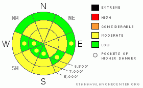
BOTTOM LINE
Danger by aspect and elevation on slopes approaching 35° or steeper.
(click HERE for tomorrow's danger rating)
|
Danger Rose Tutorial
|
There is a Level 2 or Moderate danger in the backcountry, with heightened avalanche conditions in drifted terrain, on slopes with buried persistent weak layers, and on sunny slopes with saturated fresh snow. The danger is greater in the Southern Bear River Range and in the Ogden Area Mountains due to significantly more new snow accumulation yesterday. You could trigger fresh wind slab avalanches on steep drifted slopes. Dangerous triggered deep slabs are generally unlikely and would most likely be difficult to trigger, but they are still possible in areas with a poor snow structure including buried weak snow. The danger of wet avalanches will rise with solar warming today, and could become a significant threat in areas that picked up more new snow. Loose wet avalanches could entrain large piles of heavy fresh snow on longer slopes. Continue to use safe travel protocols and evaluate the snow and terrain carefully. |
|
|
CURRENT CONDITIONS |

|
A nice refreshment consisting of several inches of somewhat heavy new fell yesterday across the region, significantly improving widespread variable wind-jacked and crusty snow conditions... More snow fell at upper elevations and in the Southern Bear River Range and as usual this time of year, the best powder riding can still be found in sheltered shady terrain. The Tony Grove Snotel at 8400' reports 8/10ths of an inch of water in the last 48 hours within 6 inches of settled snow. Its 21 degrees, and with 116 inches of total snow on the ground the station sits at 143% of normal water content for the date. |
|
|
RECENT ACTIVITY |

|
Strong winds Sunday night and Monday caused several large natural cornice falls, some of which triggered wind slab and even a few deep slab avalanches on steep slopes below. Ski Areas in the Ogden Area Mountains report new snow and fresh wind slab activity with significantly more accumulations than elsewhere. Numerous natural but no triggered avalanches were reported in the Logan Zone in the last week....
.See our avalanche list HERE
|
|
|
THREAT #1 |

|
| WHERE |
PROBABILITY |
SIZE |
TREND |

|
|
|
|
| |
|
|
Over the next
24 hours.
|
|
|
Overnight west and northwest winds built drifts and wind slabs with yesterday's fresh snow in exposed terrain...I noticed the bond between the new and the old snow was poor in some areas, with a thin layer of frost or surface hoar the probable culprit... Soft fresh wind slabs could still be fairly sensitive and easy to trigger today. Watch for and avoid drifted snow on steep slopes on the lee sides of ridges and in terrain dictated deposition areas, and be very cautious when traveling in exposed terrain above trees, gullies, benches or other terrain traps... |
|
|
THREAT #2 |

|
| WHERE |
PROBABILITY |
SIZE |
TREND |
|
|
|
|
| |
|
|
Over the next
24 hours.
|
|
|
Dangerous triggered deep slab avalanches, failing on now deeply buried January weak layers are generally unlikely but still possible in some areas, and the consequences of triggering one of these monsters could be deadly. Recent deep slab avalanches have occurred during significant loading events, with lots of rapidly applied weight from new snow and wind drifting. Overrunning snow from cornice falls triggered the most recent natural hard slabs in the zone. |
|
|
THREAT #3 |

|
| WHERE |
PROBABILITY |
SIZE |
TREND |

|
|
|
|
| |
|
|
Over the next
10 hours.
|
|
|
Solar warming will cause a heightened danger of wet avalanches. Slopes in sheltered and lower elevation areas are likely to warm up with the higher angled and more powerful spring-like sun today. Warming will cause the fresh surface snow to become moist and sticky in some areas, especially in those that received significant new snow. Watch for signs like roller balls or other wet avalanches, avoid steep slopes above terrain traps like gullies and trees, and move off slopes with saturated surface snow.... |
|
|
MOUNTAIN WEATHER |

|
Morning clouds and lingering snow showers will give way to mostly sunny conditions this afternoon, and we'll see moderate but steady west winds... Clouds will stream in overnight and temperatures will rise into the mid twenties.. We'll see increasing clouds and strengthening southwest winds tomorrow and a chance for some snowfall...Expect showery snowfall and breezy conditions Saturday night and a few inches of accumulation on Sunday.... A much more significant storm is forecast to affect the region early next week, with a couple feet or more of snow accumulation possible in some mountain areas.... |
|
|
GENERAL ANNOUNCEMENTS |
The Friends of the Utah Avalanche Center is offering an Advanced Avalanche Skills Workshop, with a classroom session in the evening of March 3 and a field session on Saturday, March 5. You need to register in advance with the USU Outdoor Recreation Program.......
You can view a photo summary of last year's avalanche activity in the Logan Area HERE
Join the friends of the Utah Avalanche Center in Logan on facebook. Click HERE
I will update this advisory in the mornings on Mondays, Wednesdays, Fridays, and Saturdays, and on other days if backcountry avalanche conditions warrant...
You have the opportunity to participate in the creation of our own community avalanche advisory by submitting avalanche and snow observations. You can also call us at 801-524-5304 or Toby at 435-757-7578, or email by clicking HERE
Donate to your favorite non-profit – The Friends of the Utah Avalanche Center. The UAC depends on contributions from users like you to support our work.
This advisory is from the U.S.D.A. Forest Service, which is solely responsible for its content. This advisory describes general avalanche conditions and local variations always occur. |
|
|
This information does not apply to developed ski areas or highways where avalanche control is normally done. This advisory is from the U.S.D.A. Forest Service, which is solely responsible for its content. This advisory describes general avalanche conditions and local variations always occur. |
|
This advisory provided by the USDA Forest Service, in partnership with:
The Friends of the Utah Avalanche Center, Utah Division of State Parks and Recreation, Utah Division of Emergency Management, Salt Lake County, Salt Lake Unified Fire Authority and the friends of the La Sal Avalanche Center. See our Sponsors Page for a complete list. |
