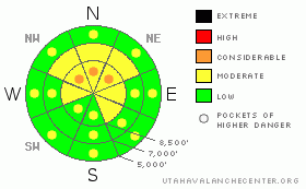
BOTTOM LINE
Danger by aspect and elevation on slopes approaching 35° or steeper.
(click HERE for tomorrow's danger rating)
|
Danger Rose Tutorial
|
The danger is Level 2 or Moderate on the majority of slopes in the zone, with heightened avalanche conditions in upper elevation drifted terrain, on slopes with buried weak layers, and on sunny slopes with saturated surface snow. You'll find pockets with a lingering level 3 or Considerable danger in some areas with buried weak snow and in shady areas with a shallow overall snowpack. Dangerous and destructive triggered deep hard slab avalanches are possible on isolated slopes steeper than about 35 degrees... Deep slab avalanches could be triggered remotely, from a distance or from below. Evaluate the snow and terrain carefully, and use conservative decision making in areas where you suspect buried weak layers... |
|
|
CURRENT CONDITIONS |

|
The south and west winds jacked the upper elevation snow, and strong solar warming certainly got to the surface snow in many areas, turning it into mush. Expect varied snow conditions again today, with nice settled powder hiding out on sheltered shady slopes... The Campbell Scientific Logan Peak weather station at 9700' reports a north-northeast wind averaging in the upper 20s overnight, with gusts of close to 40 mph and 22 degrees. Expect snowfall to develop this afternoon, and the winds to shift around from the southwest. |
|
|
RECENT ACTIVITY |

|
The Logan Area experienced a widespread natural avalanche cycle overnight Friday night. Many avalanches involving new storm snow and fresh wind slabs were observed from across the zone. But a few of the naturals stepped down into older sugary or faceted snow, and some of the deeper avalanches were quite broad and pretty scary looking. Strong winds Sunday night and Monday caused several large natural cornice falls, some of which triggered wind slab or even deep slab avalanches on slopes below.
.See our avalanche list HERE
|
|
|
THREAT #1 |

|
| WHERE |
PROBABILITY |
SIZE |
TREND |
|
|
|
|
| |
|
|
Over the next
24 hours.
|
|
|
Dangerous triggered deep slab avalanches, failing on now deeply buried January weak layers are possible in some areas, and the consequences of triggering one of these monsters could be severe. Collapsing is a sure sign of this threat and a red flag to watch for, but a deep slab avalanche could occur with no prior warning signs. You could trigger dangerous deep slab avalanches on slopes steeper than about 35 degrees with shallow or preexisting weak snow, and you might trigger this type of avalanche remotely or from a distance, and hopefully not from below.... |
|
|
THREAT #2 |

|
| WHERE |
PROBABILITY |
SIZE |
TREND |
|
|
|
|
| |
|
|
Over the next
24 hours.
|
|
|
Be cautious along major ridge-lines, and avoid the colossal overhanging cornices, which could break under your weight much further back than you expect.... Cornice pieces falling on steep drifted slopes below could trigger wind slab or possibly deep slab avalanches.. Triggered wind slab avalanches up to a couple feet deep are possible on steep, recently drifted slopes at upper elevations. Watch for rounded looking, stiffer feeling, or hollow sounding snow and obvious signs of instability, like cracking. Avoid recent wind drifts on steep slopes off the lee sides of ridges and sub-ridges, under cliff bands, around rock outcroppings, along gully walls, or in scoops or depressions. |
|
|
THREAT #3 |

|
| WHERE |
PROBABILITY |
SIZE |
TREND |
|
|
|
|
| |
|
|
Over the next
10 hours.
|
|
|
Breezy conditions and cloud cover will probably keep this threat to a minimum today, but slopes in sheltered areas are likely to warm up with the higher angled and more powerful spring-like sun this morning and increasing cloud cover could trap the heat like in a greenhouse. Warming will cause the surface snow to become moist and sticky in some areas, and there will be a heightened danger of wet avalanches. Watch for signs like roller balls or other wet avalanches, avoid steep slopes above terrain traps like gullies and trees, and move off slopes with saturated surface snow.... |
|
|
MOUNTAIN WEATHER |

|
Expect increasing clouds and winds to shift around from the southwest today, and snowfall will develop this afternoon ahead of the first of two pacific storms forecast to impact the region. We could pick up a decent shot of snow tonight, with 6 to 10 inches of accumulation forecast and sustained moderate southwest winds. More storminess and snowfall is expected tomorrow and Friday. The National Weather Service has issued a Winter Weather Advisory for this evening through Friday expecting several inches to fall in the mountains during this time-frame... |
|
|
GENERAL ANNOUNCEMENTS |
The Friends of the Utah Avalanche Center is offering an Advanced Avalanche Skills Workshop, with a classroom session in the evening of March 3 and a field session on Saturday, March 5. You need to register in advance with the USU Outdoor Recreation Program.......
You can view a photo summary of last year's avalanche activity in the Logan Area HERE
Join the friends of the Utah Avalanche Center in Logan on facebook. Click HERE
I will update this advisory in the mornings on Mondays, Wednesdays, Fridays, and Saturdays, and on other days if backcountry avalanche conditions warrant...
You have the opportunity to participate in the creation of our own community avalanche advisory by submitting avalanche and snow observations. You can also call us at 801-524-5304 or Toby at 435-757-7578, or email by clicking HERE
Donate to your favorite non-profit – The Friends of the Utah Avalanche Center. The UAC depends on contributions from users like you to support our work.
This advisory is from the U.S.D.A. Forest Service, which is solely responsible for its content. This advisory describes general avalanche conditions and local variations always occur. |
|
|
This information does not apply to developed ski areas or highways where avalanche control is normally done. This advisory is from the U.S.D.A. Forest Service, which is solely responsible for its content. This advisory describes general avalanche conditions and local variations always occur. |
|
This advisory provided by the USDA Forest Service, in partnership with:
The Friends of the Utah Avalanche Center, Utah Division of State Parks and Recreation, Utah Division of Emergency Management, Salt Lake County, Salt Lake Unified Fire Authority and the friends of the La Sal Avalanche Center. See our Sponsors Page for a complete list. |
