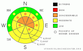
BOTTOM LINE
Danger by aspect and elevation on slopes approaching 35° or steeper.
(click HERE for tomorrow's danger rating)
|
Danger Rose Tutorial
|
The danger is Level 2 or Moderate on the majority of slopes in the zone, with heightened avalanche conditions in upper elevation drifted terrain, on slopes with buried weak layers, and on sunny slopes with saturated surface snow. You'll find a level 3 or Considerable danger and dangerous avalanche conditions on steep recently drifted slopes at upper elevations, where if you venture you could probably trigger wind slab avalanches up to a few feet deep and large cornice falls. In some areas with buried weak snow and in areas with a shallow snowpack, dangerous and destructive triggered deep hard slab avalanches are possible on slopes steeper than about 35 degrees.. Deep slab avalanches could be triggered remotely, from a distance or from below. Careful snowpack evaluation, cautious route finding, and conservative decision making are essential in avalanche terrain today. |
|
|
CURRENT CONDITIONS |

|
Around 4 feet of fresh snow fell in the zone last week, topped off by Friday's more windy and productive storm... The deep snow kept most steep upper elevation terrain inaccessible and untracked, but as the new snow settles out you are floating higher in it, and trail breaking on skis and snowmobiles is getting easier. Southwest winds picked up late yesterday and intensified overnight, while veering more from the west early this morning... We could see beautiful back-lit plumes of drifting snow coming off the high peaks and ridges yesterday evening, and significant fresh wind slabs undoubtedly formed in exposed lee terrain. The Campbell Scientific Logan Peak weather station at 9700' clocked southwest winds averaging in the thirties overnight, with gusts of close to 50 mph. The Tony Grove Snotel at 8400' reports 17 degrees this morning, and there is 118 inches of total snow on the ground containing 146% of average water for the date. |
|
|
RECENT ACTIVITY |

|
One of the Central Wasatch ski areas triggered large hard wind slabs up to around 8' deep with explosives yesterday, and we received a report of a snowmobile triggered avalanche in the Western Uintas...
The Logan Area experienced a widespread natural avalanche cycle late Friday. Many avalanches involving new storm snow and fresh wind slabs were observed from across the zone. A few of the naturals in the Wellsville Mountain Wilderness appeared to have stepped down in to older snow, and some of the deeper avalanches were quite broad and pretty scary looking.
.See our avalanche list HERE
|
|
|
THREAT #1 |

|
| WHERE |
PROBABILITY |
SIZE |
TREND |
|
|
|
|
| |
|
|
Over the next
24 hours.
|
|
|
With all the fresh snow on the ground last night's sustained and gusty southwest to west winds built deep and sensitive drifts and created fresh wind slabs in upper elevation lee terrain and deposition zones. Triggered and natural wind slab avalanches up to several feet deep are likely on steep, recently drifted slopes at upper elevations. Watch for rounded looking, stiffer feeling, or hollow sounding snow and obvious signs of instability, like cracking. Avoid recent wind drifts on steep slopes off the lee sides of ridges and sub-ridges, under cliff bands, around rock outcroppings, along gully walls, or in scoops or depressions.
Be cautious along major ridge-lines, and avoid the colossal overhanging cornices, which could break under your weight much further back than you expect.... Cornice pieces falling on steep drifted slopes below could trigger wind slab or possibly deep slab avalanches.. |
|
|
THREAT #2 |

|
| WHERE |
PROBABILITY |
SIZE |
TREND |
|
|
|
|
| |
|
|
Over the next
24 hours.
|
|
|
Dangerous triggered deep slab avalanches, failing on now deeply buried January weak layers are possible in some areas, and the consequences of triggering one of these monsters could be severe. Collapsing is a sure sign of this threat and a red flag to watch for, but a deep slab avalanche could occur with no prior warning signs. You could trigger dangerous deep slab avalanches on slopes steeper than about 35 degrees with shallow or preexisting weak snow, and you might trigger this type of avalanche remotely or from a distance, and hopefully not from below.... |
|
|
THREAT #3 |

|
| WHERE |
PROBABILITY |
SIZE |
TREND |
|
|
|
|
| |
|
|
Over the next
10 hours.
|
|
|
Breezy conditions will provide air conditioning for many sunny slopes, but those in sheltered areas are likely to warm up with the higher angled and more powerful spring-like sun. Solar warming will cause the fresh surface snow to become moist and sticky in some areas, and there will be a heightened danger of wet avalanches. Watch for signs like roller balls or other wet avalanches, avoid steep slopes above terrain traps like gullies and trees, and move off slopes with saturated surface snow.... |
|
|
MOUNTAIN WEATHER |

|
Expect a gradual warming trend and today and tomorrow with mountain high temperatures in the mid twenties. It will be a bit windy at upper elevations today and tonight with a sustained ridgetop 20-25mph southwest wind forecast and gusts of near 40 mph. The winds should diminish a bit tomorrow and temperatures will be a few degrees warmer. Our next somewhat modest looking storm arrives on Wednesday, with several inches of accumulation likely Wednesday night and Thursday.... |
|
|
GENERAL ANNOUNCEMENTS |
The Friends of the Utah Avalanche Center is offering an Advanced Avalanche Skills Workshop, with a classroom session in the evening of March 3 and a field session on Saturday, March 5. You need to register in advance with the USU Outdoor Recreation Program.......
You can view a photo summary of last year's avalanche activity in the Logan Area HERE
Join the friends of the Utah Avalanche Center in Logan on facebook. Click HERE
I will update this advisory in the mornings on Mondays, Wednesdays, Fridays, and Saturdays, and on other days if backcountry avalanche conditions warrant...
You have the opportunity to participate in the creation of our own community avalanche advisory by submitting avalanche and snow observations. You can also call us at 801-524-5304 or Toby at 435-757-7578, or email by clicking HERE
Donate to your favorite non-profit – The Friends of the Utah Avalanche Center. The UAC depends on contributions from users like you to support our work.
This advisory is from the U.S.D.A. Forest Service, which is solely responsible for its content. This advisory describes general avalanche conditions and local variations always occur. |
|
|
This information does not apply to developed ski areas or highways where avalanche control is normally done. This advisory is from the U.S.D.A. Forest Service, which is solely responsible for its content. This advisory describes general avalanche conditions and local variations always occur. |
|
This advisory provided by the USDA Forest Service, in partnership with:
The Friends of the Utah Avalanche Center, Utah Division of State Parks and Recreation, Utah Division of Emergency Management, Salt Lake County, Salt Lake Unified Fire Authority and the friends of the La Sal Avalanche Center. See our Sponsors Page for a complete list. |
