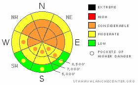
BOTTOM LINE
Danger by aspect and elevation on slopes approaching 35° or steeper.
(click HERE for tomorrow's danger rating)
|
Danger Rose Tutorial
|
There is a level 3 or Considerable danger in the backcountry, and dangerous avalanche conditions exist, mainly on drifted upper and mid elevation slopes. Natural and triggered wind slab avalanches up to a few feet deep and large cornice falls are probable in many exposed upper and mid-elevation areas. In some areas, dangerous and destructive triggered deep hard slab avalanches are possible on slopes steeper than about 35 degrees with preexisting weak layers. Deep slab avalanches could be triggered remotely, from a distance or from below. You'll find safer traveling conditions and a level 2 or Moderate danger in more sheltered, lower angled, and lower elevation terrain. Careful snowpack evaluation, cautious route finding, and conservative decision making are essential in avalanche terrain today. |
|
|
CURRENT CONDITIONS |

|
Heavy snow fell Friday and Friday night on lighter snow from earlier in the week, and the fresh powder is inverted or heavier on top. This situation makes for difficult traveling and dangerous avalanche conditions.. Cold temperatures overnight probably helped to sublimate or dry out the heavier snow near the surface.. The CSI Logan Peak weather station clocked north winds averaging in the upper teens overnight, and its 8 degrees at 9700'. The Tony Grove Snotel at 8400' reports 12 degrees this morning, and there is 122 inches of total snow on the ground containing 147% of average water for the date. |
|
|
RECENT ACTIVITY |

|
The Logan Area experienced a widespread natural avalanche cycle late Friday and or pre-dawn Saturday. Many avalanches involving new storm snow were observed from across the zone. I went up on Maple Bench to have a look at the activity with afternoon clearing.... I noted fresh avalanche activity in nearly every suspect avalanche path and on most steep slopes facing all directions and at all elevations above around 6000' in elevation. Most of these were shallow storm snow or wind slab avalanches, but it also looked like a few probably stepped down into buried January week layers.... Some of the observed slides were quite broad, with the larger and deeper avalanches on upper and mid elevation north and northeast facing slopes.....
.See our avalanche list HERE
|
|
|
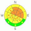
THREAT #1 |

|
| WHERE |
PROBABILITY |
SIZE |
TREND |
|
|
|
|
| |
|
|
Over the next
24 hours.
|
|
|
With all the fresh snow on the ground and falling, Friday evening's sustained and gusty southwest winds built deep and sensitive drifts and created fresh wind slabs in lee terrain and deposition zones. Triggered and natural wind slab avalanches up to several feet deep are still likely on steep, recently drifted slopes at upper and mid elevations. Watch for rounded looking, stiffer feeling, or hollow sounding snow and obvious signs of instability, like cracking. Avoid recent wind drifts on steep slopes off the lee sides of ridges and sub-ridges, under cliff bands, around rock outcroppings, along gully walls, or in scoops or depressions. |
|
|
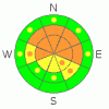
THREAT #2 |

|
| WHERE |
PROBABILITY |
SIZE |
TREND |
|
|
|
|
| |
|
|
Over the next
24 hours.
|
|
|
Dangerous triggered deep slab avalanches, failing on now deeply buried January weak layers are probable in some areas. Collapsing is a sure sign of this threat and a red flag to watch for, but a deep slab avalanche could occur with no prior warning signs. You could trigger very dangerous deep slab avalanches on slopes steeper than about 35 degrees with preexisting weak snow, and you might trigger this type of avalanche remotely or from a distance, and hopefully not from below.... |
|
|
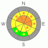
THREAT #3 |

|
| WHERE |
PROBABILITY |
SIZE |
TREND |
|
|
|
|
| |
|
|
Over the next
24 hours.
|
|
|
Be cautious along major ridge-lines, and avoid the colossal overhanging cornices, which could break under your weight much further back than you expect.... Cornice pieces falling on steep drifted slopes below could trigger wind slab or possibly deep slab avalanches.. |
|
|
MOUNTAIN WEATHER |

|
Expect a gradual warming trend and fairly benign weather for the next few days. More active weather is expected for the later half of the week, with a series of rather small impulses affecting the zone starting on around Wednesday.......... |
|
|
GENERAL ANNOUNCEMENTS |
The Friends of the Utah Avalanche Center is offering an Advanced Avalanche Skills Workshop, with a classroom session in the evening of March 3 and a field session on Saturday, March 5. You need to register in advance with the USU Outdoor Recreation Program.......
You can view a photo summary of last year's avalanche activity in the Logan Area HERE
Join the friends of the Utah Avalanche Center in Logan on facebook. Click HERE
I will update this advisory in the mornings on Mondays, Wednesdays, Fridays, and Saturdays, and on other days if backcountry avalanche conditions warrant...
You have the opportunity to participate in the creation of our own community avalanche advisory by submitting avalanche and snow observations. You can also call us at 801-524-5304 or Toby at 435-757-7578, or email by clicking HERE
Donate to your favorite non-profit – The Friends of the Utah Avalanche Center. The UAC depends on contributions from users like you to support our work.
This advisory is from the U.S.D.A. Forest Service, which is solely responsible for its content. This advisory describes general avalanche conditions and local variations always occur. |
|
|
This information does not apply to developed ski areas or highways where avalanche control is normally done. This advisory is from the U.S.D.A. Forest Service, which is solely responsible for its content. This advisory describes general avalanche conditions and local variations always occur. |
|
This advisory provided by the USDA Forest Service, in partnership with:
The Friends of the Utah Avalanche Center, Utah Division of State Parks and Recreation, Utah Division of Emergency Management, Salt Lake County, Salt Lake Unified Fire Authority and the friends of the La Sal Avalanche Center. See our Sponsors Page for a complete list. |
