AVALANCHE WARNING »
Dangerous avalanche conditions are occuring or are imminent.
Backcountry travel in avalanche terrain is not recommended.
|
 |
Notice: STRONG WINDS AND HEAVY SNOWFALL HAVE CREATED A HIGH OR LEVEL 4 AVALANCHE DANGER. DANGEROUS NATURAL AND HUMAN TRIGGERED AVALANCHES ARE LIKELY...ESPECIALLY ON STEEP WIND DRIFTED SLOPES AT THE MID AND UPPER ELEVATIONS. TRAVEL IN AVALANCHE TERRAIN...ON AND BELOW STEEP SLOPES...IS NOT RECOMMENDED. |
|
|
BOTTOM LINE
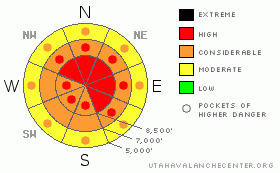
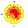
Danger by aspect and elevation on slopes approaching 35° or steeper.
(click HERE for tomorrow's danger rating)
|
Danger Rose Tutorial
|
There is a level 4 or High danger in the backcountry, and very dangerous avalanche conditions exist, mainly on drifted upper and mid elevation slopes. Natural and triggered wind slab avalanches up to a few feet deep, large cornice falls, and storm snow avalanches are all likely in many upper elevation and mid-elevation areas, especially those exposed to significant wind drifting. In some areas, dangerous triggered deep hard slab avalanches are likely on slopes steeper than about 35 degrees. Deep slab avalanches could be triggered remotely, from a distance or from below. Today is not a good day to venture into avalanche terrain... You should avoid and stay out from under steep slopes and obvious or historic avalanche paths..... |
|
|
CURRENT CONDITIONS |

|
Heavy snow fell yesterday and overnight on lighter snow from earlier in the week, and the fresh powder is inverted or heavier on top. This situation makes for difficult traveling and dangerous avalanche conditions.. Strong southwest winds picked up steam late yesterday, and the CSI Logan Peak weather station clocked nearly 35 mph average wind speeds with gusts well into the 60s yesterday evening... The Tony Grove Snotel at 8400' reports an additional 8 inches of heavier snow on the settled snow stake , with 1.5 inches of water in the last 24 hours and 2.1 inches in the last 48. It's 14 degrees this morning, and there is 129 inches of total snow on the ground containing 148% of average water for the date. Very dangerous avalanche conditions exist in the backcountry today and you should avoid and stay out from under steep slopes and obvious or historic avalanche paths.... |
|
|
RECENT ACTIVITY |

|
Numerous avalanches were reported from the northern Utah backcountry and by ski area and highway snow safety teams in the past few days, with some avalanches stepping down to now deeply buried persistent weak layers....
.See our avalanche list HERE
|
|
|
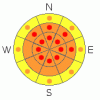
THREAT #1 |

|
| WHERE |
PROBABILITY |
SIZE |
TREND |
|
|
|
|
| |
|
|
Over the next
24 hours.
|
|
|
With all the fresh snow on the ground and falling, yesterday evening's sustained and gusty southwest winds built deep and sensitive drifts and created fresh wind slabs in lee terrain and deposition zones. Triggered and natural wind slab avalanches up to several feet deep are likely on steep recently drifted slopes at upper and mid elevations. Watch for rounded looking, stiffer feeling, or hollow sounding snow and obvious signs of instability, like cracking. Avoid recent wind drifts on steep slopes off the lee sides of ridges and sub-ridges, under cliff bands, around rock outcroppings, along gully walls, or in scoops or depressions.
Be cautious along major ridge-lines, and avoid the colossal overhanging cornices, which could break under your weight much further back than you expect.... Cornice pieces falling on steep drifted slopes below could trigger wind slab or possibly deep slab avalanches.. |
|
|
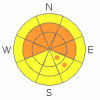
THREAT #2 |

|
| WHERE |
PROBABILITY |
SIZE |
TREND |
|
|
|
|
| |
|
|
Over the next
24 hours.
|
|
|
Dangerous triggered deep slab avalanches, failing on now deeply buried January weak layers are probable in some areas. Collapsing is a sure sign of this threat and a red flag to watch for, but a deep slab avalanche could occur with no prior warning signs. You could trigger very dangerous deep slab avalanches on slopes steeper than about 35 degrees with preexisting weak snow, and you might trigger this type of avalanche remotely or from a distance, and hopefully not from below.... |
|
|
THREAT #3 |

|
| WHERE |
PROBABILITY |
SIZE |
TREND |
|
|
|
|
| |
|
|
Over the next
24 hours.
|
|
|
Heavy snowfall yesterday and overnight accompanied by strong southwest winds laid down a heavier blanket on top of lighter snow from Thursday, and the deep powder is now inverted. We noticed failures beginning to occur on the interface and within the fresh snow yesterday afternoon.... Triggered storm snow avalanches are probable on steep slopes with significant new snow accumulations even in generally sheltered areas..... |
|
|
MOUNTAIN WEATHER |

|
The productive storm is moving off to our south this morning, but post frontal southwest winds are likely to pick up for a time today... We might pick up a couple more inches as snowfall diminishes this morning. High temperatures are expected to reach the upper teens today, and clouds and light snow will reform. Expect cool and cloudy weather to continue through the weekend, with periods of light snow. A gradual drying and warming trend is forecast for the early part of next week, with small storms expected to affect the region later in the week. No significant storms are in the forecast however.... |
|
|
GENERAL ANNOUNCEMENTS |
The Friends of the Utah Avalanche Center is offering an Advanced Avalanche Skills Workshop, with a classroom session in the evening of March 3 and a field session on Saturday, March 5. You need to register in advance with the USU Outdoor Recreation Program.......
You can view a photo summary of last year's avalanche activity in the Logan Area HERE
Join the friends of the Utah Avalanche Center in Logan on facebook. Click HERE
I will update this advisory in the mornings on Mondays, Wednesdays, Fridays, and Saturdays, and on other days if backcountry avalanche conditions warrant...
You have the opportunity to participate in the creation of our own community avalanche advisory by submitting avalanche and snow observations. You can also call us at 801-524-5304 or Toby at 435-757-7578, or email by clicking HERE
Donate to your favorite non-profit – The Friends of the Utah Avalanche Center. The UAC depends on contributions from users like you to support our work.
This advisory is from the U.S.D.A. Forest Service, which is solely responsible for its content. This advisory describes general avalanche conditions and local variations always occur. |
|
|
This information does not apply to developed ski areas or highways where avalanche control is normally done. This advisory is from the U.S.D.A. Forest Service, which is solely responsible for its content. This advisory describes general avalanche conditions and local variations always occur. |
|
This advisory provided by the USDA Forest Service, in partnership with:
The Friends of the Utah Avalanche Center, Utah Division of State Parks and Recreation, Utah Division of Emergency Management, Salt Lake County, Salt Lake Unified Fire Authority and the friends of the La Sal Avalanche Center. See our Sponsors Page for a complete list. |
