AVALANCHE WATCH »
The risk of an avalanche is expected to increase significantly
but the timing and location are still uncertain. Stay tuned for updates.
|
 |
Notice: AVALANCHE CONDITIONS WILL BECOME INCREASINGLY DANGEROUS THROUGH SATURDAY DUE TO STRONG WINDS AND ADDITIONAL SNOW. BACKCOUNTRY TRAVELERS SHOULD USE CAUTION AND AVOID TRAVEL ON AND BELOW STEEP SLOPES. |
|
|
BOTTOM LINE
Danger by aspect and elevation on slopes approaching 35° or steeper.
(click HERE for tomorrow's danger rating)
|
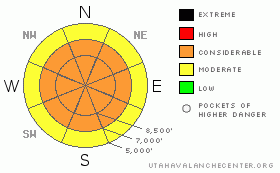
Danger Rose Tutorial
|
There is a level 3 or Considerable danger in the backcountry, and dangerous avalanche conditions exist on drifted upper and mid elevation slopes. In some areas, dangerous triggered deep hard slab avalanches are possible on slopes steeper than about 35 degrees. Some avalanches could be triggered remotely, from a distance or from below. Triggered fresh wind slab avalanches up to a few feet deep, large cornice falls, and storm snow avalanches are likely in many upper elevation and mid-elevation areas, especially those exposed to significant wind drifting. The danger will rise today and overnight, and natural avalanches will become increasingly possible with additional snowfall and increasing winds. Careful snowpack evaluation, cautious route finding, and conservative decision making are essential in avalanche terrain today. Avoid and stay out from under steep slopes and obvious or historic avalanche paths, especially during periods of heavy snowfall and strong wind..... |
|
|
CURRENT CONDITIONS |

|
Another solid foot of light snow fell in upper Franklin Basin yesterday with sustained westerly winds, and snowfall resumed this morning in the zone. The Tony Grove Snotel at 8400' reports ten inches of light new snow from the last 24 hours, containing 6/10ths of an inch of water. It's 17 degrees this morning, and there is 121 inches of total snow on the ground containing 144% of average water for the date. The Hwy 89 Logan Summit station showed sustained west and northwest winds yesterday, with perfect light snow drifting conditions and hourly average wind speeds recorded in the teens....The CSI Logan Peak wind sensor showed a somewhat suspect northeast wind direction all day yesterday, and its 10 degrees at 9700'. |
|
|
RECENT ACTIVITY |

|
A large deep slab avalanche was triggered by a snowmobiler on Wednesday on Lewis Peak in the mountains north of Park City. The avalanche was reported to be several feet deep and wide as a football pitch... Locally; some clearing on Wednesday allowed evidence of numerous recent natural avalanches to be observed in the Logan Zone But, cloud cover and continuing snowfall limited views and obscured most natural activity in the region. Skiers report triggering a manageable soft wind slab a foot deep and around 90' wide on a northeast facing slope at around 9000' in elevation in Hell's Kitchen on Wednesday. A party reports triggering an audible collapse or "whumpf" yesterday on a north facing slope at around 8700' in upper Garden City Canyon. Collapsing is a red flag indicating the potential for dangerous deep slab avalanches.... Some of the recent natural and triggered avalanches across the northern Utah mountains appear to be stepping down into now pretty deeply buried January persistent weak layers. .....See our avalanche list HERE
|
|
|
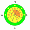
THREAT #1 |

|
| WHERE |
PROBABILITY |
SIZE |
TREND |
|
|
|
|
| |
|
|
Over the next
48 hours.
|
|
|
Dangerous deep slab avalanches, failing on January weak layers are possible in some areas. We have been able to find weak sugary or faceted snow, interlaced with graupel or surface hoar in many areas above a prominent mid-January rain-crust and very weak snow under it in most places. Recent avalanches stepping down to this layer in the Logan Zone indicate that more of this type of activity will probably occur, and the danger is rising with additional loading from sustained and increasing southwest winds and more snowfall in the forecast. Collapsing is a sure sign of this threat and a red flag to watch for, but a deep slab avalanche could occur with no prior warning signs. You could trigger persistent slab avalanches on slopes steeper than about 35 degrees with preexisting weak snow, and you might trigger this dangerous type of avalanche remotely or from a distance, and hopefully not from below.... |
|
|
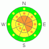
THREAT #2 |

|
| WHERE |
PROBABILITY |
SIZE |
TREND |
|
|
|
|
| |
|
|
Over the next
24 hours.
|
|
|
With all the light density snow on the ground and in the air, yesterday's sustained and gusty westerly winds built deep and sensitive drifts and created fresh wind slabs in lee terrain and deposition zones. Triggered wind slab avalanches up to several feet deep are likely on steep recently drifted slopes at upper and mid elevations. Watch for rounded looking, stiffer feeling, or hollow sounding snow and obvious signs of instability, like cracking. Avoid recent wind drifts on steep slopes off the lee sides of ridges and sub-ridges, under cliff bands, around rock outcroppings, along gully walls, or in scoops or depressions.
Be cautious along major ridge-lines, and avoid the colossal overhanging cornices, which could break under your weight much further back than you expect.... Cornice chunks falling on steep drifted slopes below could trigger wind slab or possibly deep slab avalanches.. |
|
|
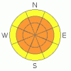
THREAT #3 |

|
| WHERE |
PROBABILITY |
SIZE |
TREND |
|
|
|
|
| |
|
|
Over the next
24 hours.
|
|
|
Heavy snowfall and strong winds are expected today and the danger of storm snow avalanches is significant. Avalanches could fail on density changes within the fresher snow, or on micro-thin weak layers created during breaks in the weather. The avalanche danger will rise throughout today and tonight, and the danger level could increase to level 4 or High overnight. A natural avalanche cycle could easily occur, especially during periods of very heavy snowfall and strong winds, so watch those campsites and stay clear of and out from under steep slopes and obvious or historic avalanche paths in the height of the storm... |
|
|
MOUNTAIN WEATHER |

|
The National Weather service has continued a Winter Storm Warning for our zone through Saturday evening. Expect 7 to 11 inches of accumulation and mountain high temperatures in the upper teens today, with increasingly strong and sustained west and southwest winds in the 30 mph range and gusts of around 45 mph. Winds should shift around from the northwest and diminish a bit tonight, with 8 to 12 inches of additional snow forecast. Snowfall and winds should taper off on Saturday, leaving us well set up for the weekend with the type weather in which avalanche accidents often occur..... |
|
|
GENERAL ANNOUNCEMENTS |
The Friends of the Utah Avalanche Center is offering an Advanced Avalanche Skills Workshop, with a classroom session in the evening of March 3 and a field session on Saturday, March 5. You need to register in advance with the USU Outdoor Recreation Program.......
You can view a photo summary of last year's avalanche activity in the Logan Area HERE
Join the friends of the Utah Avalanche Center in Logan on facebook. Click HERE
I will update this advisory in the mornings on Mondays, Wednesdays, Fridays, and Saturdays, and on other days if backcountry avalanche conditions warrant...
You have the opportunity to participate in the creation of our own community avalanche advisory by submitting avalanche and snow observations. You can also call us at 801-524-5304 or Toby at 435-757-7578, or email by clicking HERE
Donate to your favorite non-profit – The Friends of the Utah Avalanche Center. The UAC depends on contributions from users like you to support our work.
This advisory is from the U.S.D.A. Forest Service, which is solely responsible for its content. This advisory describes general avalanche conditions and local variations always occur. |
|
|
This information does not apply to developed ski areas or highways where avalanche control is normally done. This advisory is from the U.S.D.A. Forest Service, which is solely responsible for its content. This advisory describes general avalanche conditions and local variations always occur. |
|
This advisory provided by the USDA Forest Service, in partnership with:
The Friends of the Utah Avalanche Center, Utah Division of State Parks and Recreation, Utah Division of Emergency Management, Salt Lake County, Salt Lake Unified Fire Authority and the friends of the La Sal Avalanche Center. See our Sponsors Page for a complete list. |
