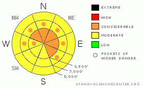
BOTTOM LINE
Danger by aspect and elevation on slopes approaching 35° or steeper.
(click HERE for tomorrow's danger rating)
|
Danger Rose Tutorial
|
There is a level 3 or Considerable danger in the backcountry, and dangerous avalanche conditions exist on drifted upper and mid elevation slopes. In some areas, dangerous triggered persistent or deep hard slab avalanches are possible on slopes steeper than about 35 degrees. Some avalanches could be triggered remotely, from a distance or from below. Triggered fresh wind slab avalanches up to a few feet deep, and large cornice falls are likely in many upper elevation areas exposed to wind drifting. You'll find better, safer, traveling conditions and a level 2 or Moderate danger in more sheltered, lower angled, and lower elevation terrain. Careful snowpack evaluation, cautious route finding, and conservative decision making are essential in avalanche terrain today. |
|
|
CURRENT CONDITIONS |

|
The deep drifted powder is a bit too much for easy traveling at upper elevations and trail breaking is difficult on skis and on a sled in the backcountry.... It's easy to get stuck on hills and there are soft drifts from yesterday deeper than I am tall.. The Tony Grove Snotel at 8400' reports several inches of light new snow from yesterday, containing 7/10ths of an inch of water. It's 12 degrees this morning, and there is 117 inches of total snow on the ground containing 144% of average water for the date. The Hwy 89 Logan Summit station showed sustained strong west and northwest winds yesterday, with gusts near 50 mph yesterday evening... |
|
|
RECENT ACTIVITY |

|
Numerous avalanches were reported yesterday across northern Utah, with some stepping down to the mid-January ice-crust... Locally; cloud cover and deep fresh snow are obscuring evidence of a fairly widespread weekend natural cycle, but a few recent natural avalanches have been observed in the Logan Zone. Some of these appear to be stepping down into January snow or buried persistent weak layers.....See our avalanche list HERE
|
|
|
THREAT #1 |

|
| WHERE |
PROBABILITY |
SIZE |
TREND |
|
|
|
|
| |
|
|
Over the next
48 hours.
|
|
|
Dangerous persistent or deep slab avalanches, failing on January weak layers are possible in some areas. We have been able to find weak sugary or faceted snow, interlaced with graupel or surface hoar in many areas above a prominent mid-January rain-crust and very weak snow under it in most places. Recent avalanches stepping down to this layer in the Logan Zone indicate that more of this type of activity will probably occur. The copious new snow and recent wind drifting across the region probably caused the danger of persistent and deep slabs to be more widespread. Collapsing is a sure sign of this threat and a red flag to watch for, but a persistent or deep slab avalanche could occur with no prior warning signs. You could trigger persistent slab avalanches on slopes steeper than about 35 degrees with preexisting weak snow, and you might trigger this dangerous type of avalanche remotely or from a distance, and hopefully not from below.... |
|
|
THREAT #2 |

|
| WHERE |
PROBABILITY |
SIZE |
TREND |
|
|
|
|
| |
|
|
Over the next
24 hours.
|
|
|
With all the light density snow on the ground and in the air, yesterday's sustained and gusty westerly winds built deep and sensitive drifts and created fresh wind slabs in lee terrain and deposition zones. Triggered wind slab avalanches up to several feet deep are likely on steep recently drifted slopes at upper and mid elevations. Watch for rounded looking, stiffer feeling, or hollow sounding snow and obvious signs of instability, like cracking. Avoid recent wind drifts on steep slopes off the lee sides of ridges and sub-ridges, under cliff bands, around rock outcroppings, along gully walls, or in scoops or depressions. |
|
|
THREAT #3 |

|
| WHERE |
PROBABILITY |
SIZE |
TREND |
|
|
|
|
| |
|
|
Over the next
24 hours.
|
|
|
Be cautious along major ridge-lines, and avoid the colossal overhanging cornices, which could break under your weight much further back than you expect.... Cornice chunks falling on steep drifted slopes below could trigger wind slab or persistent slab avalanches.. |
|
|
MOUNTAIN WEATHER |

|
It'll be mostly cloudy, chilly, and breezy in the mountains today, with a continuing sustained west wind and a chance some snow showers. The National Weather Service has issued a Winter Storm Watch for our area, and heavy snowfall is expected in the northern mountains and mountain valleys starting tomorrow and continuing through Saturday. The period with the most accumulation looks to come early Friday..... |
|
|
GENERAL ANNOUNCEMENTS |
Paige is offering a Woman's Avalanche Clinic in the field next weekend on Saturday, February 26 at 9:00. Call 435-757-2794 for more details.
The Friends of the Utah Avalanche Center is offering an Advanced Avalanche Skills Workshop, with a classroom session in the evening of March 3 and a field session on Saturday, March 5. You need to register in advance with the USU Outdoor Recreation Program.......
You can view a photo summary of last year's avalanche activity in the Logan Area HERE
Join the friends of the Utah Avalanche Center in Logan on facebook. Click HERE
I will update this advisory in the mornings on Mondays, Wednesdays, Fridays, and Saturdays, and on other days if backcountry avalanche conditions warrant...
You have the opportunity to participate in the creation of our own community avalanche advisory by submitting avalanche and snow observations. You can also call us at 801-524-5304 or Toby at 435-757-7578, or email by clicking HERE
Donate to your favorite non-profit – The Friends of the Utah Avalanche Center. The UAC depends on contributions from users like you to support our work.
This advisory is from the U.S.D.A. Forest Service, which is solely responsible for its content. This advisory describes general avalanche conditions and local variations always occur. |
|
|
This information does not apply to developed ski areas or highways where avalanche control is normally done. This advisory is from the U.S.D.A. Forest Service, which is solely responsible for its content. This advisory describes general avalanche conditions and local variations always occur. |
|
This advisory provided by the USDA Forest Service, in partnership with:
The Friends of the Utah Avalanche Center, Utah Division of State Parks and Recreation, Utah Division of Emergency Management, Salt Lake County, Salt Lake Unified Fire Authority and the friends of the La Sal Avalanche Center. See our Sponsors Page for a complete list. |
