AVALANCHE WARNING »
Dangerous avalanche conditions are occuring or are imminent.
Backcountry travel in avalanche terrain is not recommended.
|
 |
Notice: A NATURAL AVALANCHE CYCLE IS IN PROGRESS. LARGE AMOUNTS OF NEW SNOW WITH WIND HAS CREATED A HIGH AVALANCHE DANGER. PEOPLE SHOULD AVOID ANY STEEP MOUNTAINOUS SLOPES TODAY AND INTO MONDAY. WITH THE WEATHER CLEARING SOMEWHAT ON MONDAY AND LINGERING UNSTABLE SNOW, THE BUSY HOLIDAY IS RIPE FOR AN AVALANCHE ACCIDENT. |
|
|
BOTTOM LINE
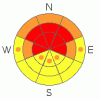
Danger by aspect and elevation on slopes approaching 35° or steeper.
(click HERE for tomorrow's danger rating)
|

Danger Rose Tutorial
|
There is a level 4 or High danger in the backcountry, and very dangerous avalanche conditions exist on upper and mid elevation slopes facing the northern third of the compass. Triggered and natural dangerous persistent slab avalanches 2 to 4 feet deep are likely and are naturally occurring on slopes approaching or steeper than about 35 degrees. Cornice fall, wind slab, and storm snow avalanches are also likely in many areas. Avoid travel in avalanche terrain today, and stay off of and out from under steep slopes and obvious or historic avalanche paths..... |
|
|
CURRENT CONDITIONS |

|
More than expected new snow overnight and already dangerous avalanche conditions in the backcountry should dictate re-assessment of your riding plans today... It will be a good day to use the lifts up at the Beav, and you'll certainly want to avoid riding on or below steep slopes and avalanche terrain in the backcountry.... The Tony Grove Snotel at 8400' reports a foot of heavy new snow containing 1.5 inches of water in the last 24 hours, and most of this fell in the last few hours. It's 22 degrees this morning, and there is 107 inches of total snow on the ground containing 142% of average water for the date. The Snotel site on Ben Lomond reports almost 3 inches of water.. The Campbell Scientific Logan Peak weather station at 9700' reports 12 degrees this morning with moderating west winds currently averaging in the low teens. The station recorded strong and sustained south winds yesterday, with a few degrees of easterly direction component in the morning..... |
|
|
RECENT ACTIVITY |

|
The action was south of Logan Canyon yesterday, and two parties report triggering dangerous avalanches failing and running on buried persistent weak layers. One party remote triggered large cornice falls and an impressive and destructive 2 to 4 foot deep hard slab at around 9000' off the north side of the Millville Peak-Long Mountain ridgeline. Another party of three triggered three separate 1 to 2 foot deep soft slabs under the cliffs in Spring Hollow on a north facing slope at around 8100'. In this case, one of the avalanches caught and carried two skiers around 500 vertical feet, burying one up to his neck and immobilizing him in concrete-like debris... Luckily, they recovered most of their lost equipment with a bit of effort.
|
|
|
THREAT #1 |

|
| WHERE |
PROBABILITY |
SIZE |
TREND |
|
|
|
|
| |
|
|
Over the next
12 hours.
|
|
|
The culprit buried weak layer of highest concern exists on the shady half of the compass, dates back to the end of January, and was only shallowly buried before Thursday night's storm, not far above the very solid MLK ice-crust.... It is made up of faceted snow, graupel and in some cases feathery surface hoar. Yesterday, the drifted fresh snow contained enough weight and was cohesive enough to activate this persistent weak layer in north facing terrain in the vicinity of Logan Peak... Last night's heavy new snow will likely cause the danger to be much more widespread today. There is also weak snow in most areas lurking just under the prominent, and in some cases deteriorating, mid-January crust. You could trigger persistent slab avalanches on slopes approaching or steeper than about 35 degrees, and you might trigger this dangerous type of avalanche remotely or from a distance, and hopefully not from below.... |
|
|
THREAT #2 |

|
| WHERE |
PROBABILITY |
SIZE |
TREND |
|
|
|
|
| |
|
|
Over the next
24 hours.
|
|
|
Be cautious along major ridge-lines, and avoid the colossal overhanging cornices, which could break under your weight much further back than you expect.... Cornice chunks falling on steep drifted slopes below could trigger wind slab or persistent slab avalanches.. |
|
|
THREAT #3 |

|
| WHERE |
PROBABILITY |
SIZE |
TREND |
|
|
|
|
| |
|
|
Over the next
12 hours.
|
|
|
Triggered and natural wind slab avalanches and storm snow avalanches are likely on steep drifted slopes Avoid recent wind drifts on steep slopes off the lee sides of ridges and sub-ridges, under cliff bands, around rock outcroppings, along gully walls, or in scoops or depressions. More snowfall and continuing west winds will cause a further increase in danger today... |
|
|
MOUNTAIN WEATHER |

|
A good snow storm is upon us today and 8 to 12 additional inches of accumulation are forecast for the mountains today, with sustained moderate west winds. A few more inches could fall tonight, but things should tapper off, with a short-lived ridge over the region on Monday. Looks like we'll see more snowy weather in the coming week as the Pacific trough establishes residency over the inter-mountain west... |
|
|
GENERAL ANNOUNCEMENTS |
Paige is offering a Woman's Avalanche Clinic in the field next weekend on Saturday, February 26 at 9:00. Call 435-757-2794 for more details.
The Friends of the Utah Avalanche Center is offering an Advanced Avalanche Skills Workshop, with a classroom session in the evening of March 3 and a field session on Saturday, March 5. You need to register in advance with the USU Outdoor Recreation Program.......
You can view a photo summary of last year's avalanche activity in the Logan Area HERE
Join the friends of the Utah Avalanche Center in Logan on facebook. Click HERE
I will update this advisory in the mornings on Mondays, Wednesdays, Fridays, and Saturdays, and on other days if backcountry avalanche conditions warrant...
You have the opportunity to participate in the creation of our own community avalanche advisory by submitting avalanche and snow observations. You can also call us at 801-524-5304 or Toby at 435-757-7578, or email by clicking HERE
Donate to your favorite non-profit – The Friends of the Utah Avalanche Center. The UAC depends on contributions from users like you to support our work.
This advisory is from the U.S.D.A. Forest Service, which is solely responsible for its content. This advisory describes general avalanche conditions and local variations always occur. |
|
|
This information does not apply to developed ski areas or highways where avalanche control is normally done. This advisory is from the U.S.D.A. Forest Service, which is solely responsible for its content. This advisory describes general avalanche conditions and local variations always occur. |
|
This advisory provided by the USDA Forest Service, in partnership with:
The Friends of the Utah Avalanche Center, Utah Division of State Parks and Recreation, Utah Division of Emergency Management, Salt Lake County, Salt Lake Unified Fire Authority and the friends of the La Sal Avalanche Center. See our Sponsors Page for a complete list. |
