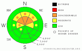
BOTTOM LINE
Danger by aspect and elevation on slopes approaching 35° or steeper.
(click HERE for tomorrow's danger rating)
|
Danger Rose Tutorial
|
There is a level 2 or Moderate danger in the backcountry, and heightened avalanche conditions exist on drifted upper elevation slopes. Triggered wind slab avalanches 1 to 3+ feet deep are possible on slopes steeper than about 35 degrees in upper elevation lee terrain, and you could still trigger dangerous cornice falls off wind exposed ridge-lines. Dangerous and destructive persistent slabs, involving older snow, are unlikely but possible on isolated steep and recently wind-loaded slopes. You will find a level 1 or Low danger and generally stable snow at lower elevations and in most sheltered terrain. Continue to practice safe travel protocols and evaluate the snow and terrain carefully today, especially on recently drifted slopes. |
|
|
CURRENT CONDITIONS |

|
If you stay out of terrain exposed to west and south winds, you'll find pretty good riding and generally stable snow. We found very nice shallow and medium depth powder conditions in the Central Bear River Range yesterday. Observers report that you could still feel crusts at lower elevations, on very steep slopes, south facing, and windward slopes, but things smoothed in nicely in a lot of mid and upper elevation terrain. The sun came out for a little while in the afternoon, and a sun-crust likely developed on many lower and mid elevation sunny slopes.
The Tony Grove Snotel at 8400' reports 26 degrees this morning, with 95 inches of total snow on the ground containing 138% of average water for the date. The Campbell Scientific Logan Peak weather station at 9700' reports 22 degrees with sustained south-southwest winds putting out 30 mph hourly average wind speeds and gusting near 50 mph this morning.... |
|
|
RECENT ACTIVITY |

|
Very strong and sustained winds whipped up the fresh snow in the Western Uinta Range in the last couple days. Several large natural avalanches stepping into old snow, at least one scary close call, and dangerous avalanche conditions in the backcountry resulted. Link to Uinta Advisory HERE
Locally; only a few small and manageable ridge-top wind slabs and a couple dry sluffs were reported from steep terrain in the backcountry yesterday. A snowmobiler went for a nice ride when a large cornice broke out under him up on Cornice Ridge last weekend. He was wearing a helmet-cam and caught some heart-pumping footage of the event. HERE
|
|
|
THREAT #1 |

|
| WHERE |
PROBABILITY |
SIZE |
TREND |
|
|
|
|
| |
|
|
Over the next
24 hours.
|
|
|
Triggered wind slab avalanches are possible on drifted slopes steeper than about 35 degrees... Sustained west winds continued to drift snow in exposed terrain yesterday and shifted around from the south overnight. The winds scoured the nice fresh powder snow off exposed windward slopes and drifted it into stiff wind slabs in lee terrain. We could find stiff wind slabs in the 1 to 3+ foot deep range in exposed upper elevation deposition areas today. Although stubborn, some of these may be sensitive to human triggering. Stiff wind slabs sometimes allow you to get out on them before failing. Avoid recent wind drifts on steep slopes off the lee sides of ridges and sub-ridges, under cliff bands, around rock outcroppings, along gully walls, or in scoops or depressions. More snowfall and continuing southeast winds will probably cause an increase in danger today... |
|
|
THREAT #2 |

|
| WHERE |
PROBABILITY |
SIZE |
TREND |

|
|
|
|
| |
|
|
Over the next
24 hours.
|
|
|
Be cautious along major ridge-lines, and avoid the colossal overhanging cornices, which could break under your weight much further back than you expect.... Cornice chunks falling on steep drifted slopes below could trigger wind slab avalanches.. Triggered and manageable loose dry avalanches or sluffs are also still fairly likely on very steep slopes... |
|
|
THREAT #3 |

|
| WHERE |
PROBABILITY |
SIZE |
TREND |
|
|
|
|
| |
|
|
Over the next
24
hours.
|
|
|
The buried weak layer of highest concern exists on the shady half of the compass, dates back to the end of January, and was only shallowly buried by 3 to 6 inches before Thursday night's storm... It is made up of faceted snow and in some cases feathery surface hoar. Drifted fresh snow may contain enough weight and be cohesive enough to activate this persistent weak layer, which is not far above the very solid MLK ice-crust. There is also weak snow in most areas lurking just under the prominent, and in some cases deteriorating, mid-January crust. You might trigger a persistent slab avalanche on isolated steep slopes remotely or from a distance, and hopefully not from below.... |
|
|
MOUNTAIN WEATHER |

|
A storm will move into the region from the south today, and we'll see sustained southeast and south winds and a bit of snow today, with 2 to 4 inches expected to accumulate in the mountains. Snowfall will continue under a southerly flow tonight, and winds will shift from the northwest tomorrow with snow continuing up high. We could see a light foot to 18 inches of accumulation in favored mountain locations by tomorrow night. Snowfall and continuing winds will cause the avalanche danger to rise in the backcountry, and dangerous conditions are likely to develop tomorrow.... More snow is likely in the mountains next week... |
|
|
GENERAL ANNOUNCEMENTS |
Paige is offering a Woman's Avalanche Clinic in the field next weekend on Saturday, February 26 at 9:00. Call 435-757-2794 for more details.
The Friends of the Utah Avalanche Center is offering an Advanced Avalanche Skills Workshop, with a classroom session in the evening of March 3 and a field session on Saturday, March 5. You need to register in advance with the USU Outdoor Recreation Program.......
You can view a photo summary of last year's avalanche activity in the Logan Area HERE
Join the friends of the Utah Avalanche Center in Logan on facebook. Click HERE
I will update this advisory in the mornings on Mondays, Wednesdays, Fridays, and Saturdays, and on other days if backcountry avalanche conditions warrant...
You have the opportunity to participate in the creation of our own community avalanche advisory by submitting avalanche and snow observations. You can also call us at 801-524-5304 or Toby at 435-757-7578, or email by clicking HERE
Donate to your favorite non-profit – The Friends of the Utah Avalanche Center. The UAC depends on contributions from users like you to support our work.
This advisory is from the U.S.D.A. Forest Service, which is solely responsible for its content. This advisory describes general avalanche conditions and local variations always occur. |
|
|
This information does not apply to developed ski areas or highways where avalanche control is normally done. This advisory is from the U.S.D.A. Forest Service, which is solely responsible for its content. This advisory describes general avalanche conditions and local variations always occur. |
|
This advisory provided by the USDA Forest Service, in partnership with:
The Friends of the Utah Avalanche Center, Utah Division of State Parks and Recreation, Utah Division of Emergency Management, Salt Lake County, Salt Lake Unified Fire Authority and the friends of the La Sal Avalanche Center. See our Sponsors Page for a complete list. |
