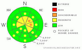
BOTTOM LINE
Danger by aspect and elevation on slopes approaching 35° or steeper.
(click HERE for tomorrow's danger rating)
|
Danger Rose Tutorial
|
There is a level 2 or Moderate danger in the backcountry, and heightened avalanche conditions exist, mainly on drifted upper elevation slopes. Triggered wind slab avalanches 1 to 2 feet deep are possible in drifted lee terrain, and you could trigger dangerous cornice falls off exposed ridge-lines. Dangerous and destructive persistent slabs, involving older snow, are possible on some steep recently drifted slopes. You will find less dangerous conditions and generally stable snow at lower elevations and in sheltered terrain unless solar warming causes the fresh surface snow to become moist or saturated, in which case loose wet activity will be possible... Continue to practice safe travel protocols and evaluate the snow and terrain carefully today, especially on recently drifted slopes. |
|
|
CURRENT CONDITIONS |

|
We found very nice shallow powder riding conditions yesterday. You could still feel the old tracks and crusts at lower and mid-elevations, but things have smoothed in nicely up higher. The Tony Grove Snotel at 8400' reported around 11 inches of new snow with an inch of water Thursday night. The station reports 18 degrees this morning, with 97 inches of total snow on the ground containing 139% of average water for the date. The CSI Logan Peak weather station at 9700' reports 15 degrees with sustained west winds putting out hourly average wind speeds in the mid-twenties and gusting up to 43 mph earlier this morning.... |
|
|
RECENT ACTIVITY |

|
Snow safety teams in the Wasatch triggered soft wind slabs with explosives, but only dry loose sluffs and a few fresh cornice falls were reported from the Northern Utah backcountry yesterday..... It appears natural activity was confined to a few good sized cornice falls in the Logan Zone, with no more significant avalanches reported or observed.
A snowmobiler went for a nice ride when a large cornice broke out under him up on Cornice Ridge last Sunday. He was wearing a helmet-cam and caught some heart-pumping footage of the event. HERE
|
|
|
THREAT #1 |

|
| WHERE |
PROBABILITY |
SIZE |
TREND |
|
|
|
|
| |
|
|
Over the next
24 hours.
|
|
|
Triggered wind slab avalanches are possible on drifted slopes steeper than about 35 degrees... West winds picked up steam yesterday afternoon, creating beautiful back-lit plumes off the ridge lines. The winds scoured the nice fresh powder snow off exposed windward slopes and drifted it into stiff wind slabs in lee terrain. We'll see wind slabs in the 1 to 2 foot deep range in exposed terrain today, and some of these are still likely to be sensitive to human triggering. Avoid recent wind drifts on steep slopes off the lee sides of ridges and sub-ridges, under cliff bands, around rock outcroppings, along gully walls, or in scoops or depressions. |
|
|
THREAT #2 |

|
| WHERE |
PROBABILITY |
SIZE |
TREND |
|
|
|
|
| |
|
|
Over the next
24 hours.
|
|
|
Be cautious along major ridge-lines, and avoid the colossal overhanging cornices, which could break under your weight much further back than you expect.... Cornice chunks falling on drifted slopes below could trigger wind slab avalanches.. |
|
|
THREAT #3 |

|
| WHERE |
PROBABILITY |
SIZE |
TREND |
|
|
|
|
| |
|
|
Over the next
24
hours.
|
|
|
The buried weak layer of highest concern exists on the shady half of the compass, dates back to the end of January, and was only shallowly buried by 3 to 6 inches before Thursday night's storm... It is made up of faceted snow and in some cases feathery surface hoar. Drifted fresh snow may contain enough weight and be cohesive enough to activate this persistent weak layer, which is not far above the very solid MLK ice-crust, a perfect bed surface that might allow avalanches to run fast and far. -You might trigger a persistent slab avalanche remotely or from a distance, and hopefully not from below....
If the clouds thin or break for a time, solar warming could cause the fresh surface snow to become moist or saturated on some lower elevation slopes, and loose wet avalanches will become a possibility. You should avoid gullies and other potential terrain traps if the fresh snow starts to get sticky.... |
|
|
MOUNTAIN WEATHER |

|
Expect mostly cloudy, breezy, and fairly mild weather in the mountains today. Periods of snowfall are likely to develop this weekend, with a bit of snow and a southeast wind forecast for tomorrow. South winds are forecast to again intensify Saturday night and another foot or so of accumulation is possible by Sunday evening... |
|
|
GENERAL ANNOUNCEMENTS |
You can view a photo summary of last year's avalanche activity in the Logan Area HERE
Join the friends of the Utah Avalanche Center in Logan on facebook. Click HERE
I will update this advisory in the mornings on Mondays, Wednesdays, Fridays, and Saturdays, and on other days if backcountry avalanche conditions warrant...
You have the opportunity to participate in the creation of our own community avalanche advisory by submitting avalanche and snow observations. You can also call us at 801-524-5304 or Toby at 435-757-7578, or email by clicking HERE
Donate to your favorite non-profit – The Friends of the Utah Avalanche Center. The UAC depends on contributions from users like you to support our work.
This advisory is from the U.S.D.A. Forest Service, which is solely responsible for its content. This advisory describes general avalanche conditions and local variations always occur. |
|
|
This information does not apply to developed ski areas or highways where avalanche control is normally done. This advisory is from the U.S.D.A. Forest Service, which is solely responsible for its content. This advisory describes general avalanche conditions and local variations always occur. |
|
This advisory provided by the USDA Forest Service, in partnership with:
The Friends of the Utah Avalanche Center, Utah Division of State Parks and Recreation, Utah Division of Emergency Management, Salt Lake County, Salt Lake Unified Fire Authority and the friends of the La Sal Avalanche Center. See our Sponsors Page for a complete list. |
