BOTTOM LINE
Danger by aspect and elevation on slopes approaching 35° or steeper.
(click HERE for tomorrow's danger rating)
|
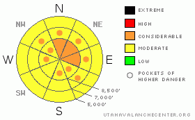
Danger Rose Tutorial
|
There is a level 3 or Considerable danger in the backcountry, and dangerous avalanche conditions exist, mainly on drifted upper and mid elevation slopes. Triggered wind slab avalanches up to around 2 feet deep are likely in drifted lee terrain in areas that picked up around a foot or more of new snow, and you could also trigger storm snow or more dangerous persistent slabs on some slopes approaching or steeper than about 35 degrees.. You will find much less dangerous conditions at lower elevations and in sheltered terrain... |
|
|
CURRENT CONDITIONS |

|
The Tony Grove Snotel at 8400' reports 11 inches of new snow with around 9/10ths of an inch of water overnight. The station reports 98 inches of total snow on the ground containing 140% of average water for the date. Franklin Basin, Doc Daniel, and Beaver Mt. all report around 8 inches of new snow overnight, with about half that at Ben Lomond.... Very strong southwest winds yesterday shifted around from the northwest with frontal passage and maintained 20 mph hourly averages before diminishing early this morning.. The CSI Logan Peak weather station at 9700' reports 8 degrees with variable wind directions and speeds averaging less than 5 mph this morning.... Expect increasing southwest winds today.... |
|
|
RECENT ACTIVITY |

|
No avalanches were reported from the Northern Utah backcountry yesterday.....
A snowmobiler went for a nice ride when a large cornice broke out under him up on Cornice Ridge Sunday. He was wearing a helmet-cam and caught some heart-pumping footage of the event. HERE
|
|
|
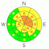
THREAT #1 |

|
| WHERE |
PROBABILITY |
SIZE |
TREND |
|
|
|
|
| |
|
|
Over the next
24 hours.
|
|
|
Triggered wind slab avalanches are likely on drifted slopes steeper than about 35 degrees... Strong southwest winds shifted around from the northwest with frontal passage last night and maintained plenty of drifting strength for a couple hours before diminishing significantly early this morning... Surely, we'll see substantial drifts in exposed terrain today, and many of these are likely to be sensitive to triggering. Slabs consisting of fresh drifted snow likely formed over broad areas and in lee terrain well below ridge lines. Avoid fresh wind drifts on steep slopes off the lee sides of ridges and sub-ridges, under cliff bands, around rock outcroppings, along gully walls, or in scoops or depressions. Many drifts are probably obscured by a few inches of less wind affected snow. |
|
|
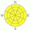
THREAT #2 |

|
| WHERE |
PROBABILITY |
SIZE |
TREND |
|
|
|
|
| |
|
|
Over the next
24
hours.
|
|
|
Storm snow avalanches in less obviously drifted or more sheltered terrain are possible on steep slopes with significant deposits of new snow. In some protected areas, we found fairly weak surface snow earlier in the week, and the bond between the old and new snow may not be so good today. Storms with periods of heavy snow and strong winds can load significant fresh slabs into usually more sheltered lee slope areas, often well below ridge lines... |
|
|
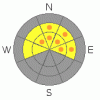
THREAT #3 |

|
| WHERE |
PROBABILITY |
SIZE |
TREND |
|
|
|
|
| |
|
|
Over the next
24
hours.
|
|
|
The buried weak layer of highest concern exists on the shady half of the compass, dates back to the end of January, and was only shallowly buried by 3 to 6 inches before last night's storm... It is made up of faceted snow and in some cases feathery surface hoar. The new snow may contain enough weight and be cohesive enough to activate this persistent weak layer, which is not far above the very solid MLK ice-crust, a perfect bed surface that might allow avalanches to run fast and far. Dangerous and destructive hard slab avalanches involving old snow, running on January weak layers below the ice-crust, and in the 2 to 4 foot-deep range are unlikely but still possible on isolated slopes with significant recent wind and new snow loading and existing buried weak layers. -You might trigger a persistent slab avalanche remotely or from a distance, and hopefully not from below.... |
|
|
MOUNTAIN WEATHER |

|
Looks like a fairly nice day, with a few more inches of accumulation possible and moderate southwest winds... We'll see a return to winter with sub-zero wind chills and breezy conditions for the next couple days. The next wave of storminess will affect the region over the weekend, with accumulating snow likely on around Saturday night, but the focus of the brunt of the storm will probably pass to our south.... |
|
|
GENERAL ANNOUNCEMENTS |
You can view a photo summary of last year's avalanche activity in the Logan Area HERE
Join the friends of the Utah Avalanche Center in Logan on facebook. Click HERE
I will update this advisory in the mornings on Mondays, Wednesdays, Fridays, and Saturdays, and on other days if backcountry avalanche conditions warrant...
You have the opportunity to participate in the creation of our own community avalanche advisory by submitting avalanche and snow observations. You can also call us at 801-524-5304 or Toby at 435-757-7578, or email by clicking HERE
Donate to your favorite non-profit – The Friends of the Utah Avalanche Center. The UAC depends on contributions from users like you to support our work.
This advisory is from the U.S.D.A. Forest Service, which is solely responsible for its content. This advisory describes general avalanche conditions and local variations always occur. |
|
|
This information does not apply to developed ski areas or highways where avalanche control is normally done. This advisory is from the U.S.D.A. Forest Service, which is solely responsible for its content. This advisory describes general avalanche conditions and local variations always occur. |
|
This advisory provided by the USDA Forest Service, in partnership with:
The Friends of the Utah Avalanche Center, Utah Division of State Parks and Recreation, Utah Division of Emergency Management, Salt Lake County, Salt Lake Unified Fire Authority and the friends of the La Sal Avalanche Center. See our Sponsors Page for a complete list. |
