BOTTOM LINE
Danger by aspect and elevation on slopes approaching 35° or steeper.
(click HERE for tomorrow's danger rating)
|
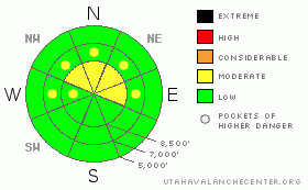
Danger Rose Tutorial
|
There is a level 1 or Low danger on most slopes, and the snow is generally stable today... The primary exceptions are in drifted terrain, where a Level 2 danger exists and you could trigger stiff wind slabs or dangerous hard slab avalanches on some slopes steeper than about 35 degrees. Continue to practice safe travel protocols and evaluate the snow and terrain carefully today, especially on recently drifted slopes... Heavy snowfall and very strong south and west winds will cause the danger to rise significantly overnight tonight, and you should expect to find dangerous avalanche conditions in the backcountry tomorrow... |
|
|
CURRENT CONDITIONS |

|
Wind intensified overnight and the CSI weather station at 9700' on Logan Peak is recording 30+ mph hourly average west winds and 26 degrees at 6:00 this morning. The Tony Grove Snotel reports another marginal overnight refreeze and temperatures dropped only a little overnight, reading 32 degrees this morning... Apparently, we picked up a couple inches of snow last night, with 2/10ths of an inch of water, and there's 88 inches of total snow on the ground at 8400'. |
|
|
RECENT ACTIVITY |

|
No avalanches were reported from the Northern Utah backcountry yesterday. Locally; I noticed a few recent wind slab and cornice fall type avalanches in the Tony Grove Area on Monday, but drifting has obscured much of the evidence of spotty recent natural activity...A snowmobiler went for a nice ride when a large cornice broke out under him up on Cornice Ridge Sunday. He was wearing a helmet-cam and caught some heart-pumping footage of the event. HERE
|
|
|
THREAT #1 |

|
| WHERE |
PROBABILITY |
SIZE |
TREND |
|
|
|
|
| |
|
|
Over the next
24 hours.
|
|
|
Some of the recently formed stiff wind slabs are resting on weak sugary snow and/or feathery surface hoar above a solid ice-crust from mid-January rain. Watch for and avoid recent wind drifts on steep slopes off the lee sides of ridges and sub-ridges, under cliff bands, around rock outcroppings, along gully walls, or in scoops or depressions. Wind slab avalanches are possible on drifted slopes steeper than about 35 degrees... Dangerous and destructive hard slab avalanches involving old snow, running on January weak layers below the ice-crust, and in the 2 to 4 foot-deep range are unlikely but still possible on isolated slopes with significant recent wind loading and existing buried weak layers. Other than the presence of recently drifted snow, there may be no prior warning signs, but remember that collapsing is a major red flag. You might trigger a persistent slab avalanche remotely or from a distance, and hopefully not from below.... |
|
|
THREAT #2 |

|
| WHERE |
PROBABILITY |
SIZE |
TREND |
|
|
|
|
| |
|
|
Over the next
24
hours.
|
|
|
Ridgetop cornices could break further back and be larger than expected, and falling cornice chunks might trigger wind slab avalanches on slopes below. |
|
|
MOUNTAIN WEATHER |

|
The National Weather Service has issued a Winter Storm Warning for the mountains of Northern Utah through tomorrow evening. Strong south winds and heavy snowfall are forecast beginning later this afternoon, intensifying tonight with frontal passage, and gradually tapering off by tomorrow evening. A foot or so of accumulation is likely at higher elevations, with more possible in areas favored by a southwest flow. Ridgetop winds could reach average windspeeds of nearly 50 mph and gusts of over 60 are quite possible... Thunderstorms and heavy snowfall are likely to accompany the frontal passage around prime-time tonight... The weather pattern changes today, and more productive storms are stacked up across the Pacific. It looks like we're in for some active weather and a fair amount of snow in the near future... This will cause the avalanche danger to rise dramatically in the backcountry, and you'll have to be on top of your game..... |
|
|
GENERAL ANNOUNCEMENTS |
You can view a photo summary of last year's avalanche activity in the Logan Area HERE
Join the friends of the Utah Avalanche Center in Logan on facebook. Click HERE
I will update this advisory in the mornings on Mondays, Wednesdays, Fridays, and Saturdays, and on other days if backcountry avalanche conditions warrant...
You have the opportunity to participate in the creation of our own community avalanche advisory by submitting avalanche and snow observations. You can also call us at 801-524-5304 or Toby at 435-757-7578, or email by clicking HERE
Donate to your favorite non-profit – The Friends of the Utah Avalanche Center. The UAC depends on contributions from users like you to support our work.
This advisory is from the U.S.D.A. Forest Service, which is solely responsible for its content. This advisory describes general avalanche conditions and local variations always occur. |
|
|
This information does not apply to developed ski areas or highways where avalanche control is normally done. This advisory is from the U.S.D.A. Forest Service, which is solely responsible for its content. This advisory describes general avalanche conditions and local variations always occur. |
|
This advisory provided by the USDA Forest Service, in partnership with:
The Friends of the Utah Avalanche Center, Utah Division of State Parks and Recreation, Utah Division of Emergency Management, Salt Lake County, Salt Lake Unified Fire Authority and the friends of the La Sal Avalanche Center. See our Sponsors Page for a complete list. |
