BOTTOM LINE
Danger by aspect and elevation on slopes approaching 35° or steeper.
(click HERE for tomorrow's danger rating)
|
Danger Rose Tutorial
|
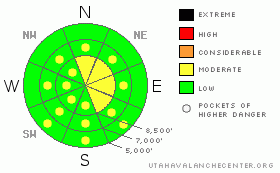
There are areas and pockets with a level 2 or Moderate danger in the backcountry around Logan, and heightened avalanche conditions exist on some steep drifted slopes. You could trigger wind slab avalanches, mainly at upper elevations and in exposed, lee terrain. Although fairly unlikely, more dangerous hard slab avalanches running on buried persistent weak layers are still possible in isolated places with significant deposits of recently drifted snow. Solar warming will cause a possibility of wet avalanches on sunny slopes with damp or saturated surface snow. Despite the potential exceptions, the danger is Level 1 or Low and the snow appears stable on most slopes in the zone. Continue to practice safe travel protocols and evaluate the snow and terrain carefully, especially on drifted slopes... |
|
|
CURRENT CONDITIONS |

|
Again, we found quality shallow, cold and fast powder riding conditions yesterday, with the best conditions seemingly in lower angled shady and sheltered terrain. The Tony Grove Snotel at 8400' reports 15 degrees and 93 inches of total snow on the ground, containing 142% of normal water content for the date. |
|
|
RECENT ACTIVITY |

|
One party reports triggering a couple small soft and manageable wind slab avalanches in the Tony Grove Area yesterday. Monday afternoon, we remote triggered a fairly large hard slab avalanche from around 40 feet away on our way down the lower Steam Mill/White Pine ridge. The avalanche included a fair amount of freshly drifted snow but it also stepped down into old snow well below the thick and solid MLK rain-crust, running on the surface hoar/ facet layer that was buried and preserved a month ago on 1/8! There were also a handful of natural avalanches observed earlier in the week.
Check our backcountry avalanche list.... HERE |
|
|
THREAT #1 |

|
| WHERE |
PROBABILITY |
SIZE |
TREND |

|
|
|
|
| |
|
|
Over the next
24 hours.
|
|
|
You might find wind slabs mainly on slopes facing north through southeast today, with recent west and northwest winds, and increasing west-southwest winds forecast for today. A couple inches of very light fresh snow fell up high in the last couple days, and there is plenty of transportable snow that could be drifted into wind slabs. Watch for and avoid wind drifts on steep slopes off the lee sides of ridges and sub-ridges, under cliff bands, around rock outcroppings, along gully walls, or in scoops or depressions. Cracking in the surface snow is a red flag. Ridgetop cornices could break further back and be larger than expected, and falling cornice chunks might trigger wind slab avalanches on slopes below. |
|
|
THREAT #2 |

|
| WHERE |
PROBABILITY |
SIZE |
TREND |

|
|
|
|
| |
|
|
Over the next
24
hours.
|
|
|
Dangerous and destructive hard slab avalanches involving old snow and in the 1 to 3 foot-deep range are possible on isolated slopes with significant recent wind loading and existing buried weak layers. Other than the presence of recently drifted snow, there may be no prior warning signs, but remember that collapsing is a major red flag. You might trigger a persistent slab avalanche remotely or from a distance, and hopefully not from below.... |
|
|
THREAT #3 |

|
| WHERE |
PROBABILITY |
SIZE |
TREND |

|
|
|
|
| |
|
|
Over the next
10 hours.
|
|
|
Many sunny slopes may be initially affected by the higher angled February sun, and wet avalanches are possible on any slope where the fresh surface snow becomes damp or saturated. |
|
|
MOUNTAIN WEATHER |

|
We'll see a good deal of sunshine in the mountains today and through the weekend, with a high pressure building over the area. Mountain temperatures will warm up a bit today with a high of about 23 degrees forecast for 8000', and moderate west and southwest winds. It will be 10 degrees warmer in the mountains tomorrow, and the southwest winds will be intensifying a bit. We'll get a slight chance of snow Monday night, and a shift in the weather pattern, with a deep through and stormy conditions to move over our area around mid week.... |
|
|
GENERAL ANNOUNCEMENTS |
You can view a photo summary of last year's avalanche activity in the Logan Area HERE
Join the friends of the Utah Avalanche Center in Logan on facebook. Click HERE
I will update this advisory in the mornings on Mondays, Wednesdays, Fridays, and Saturdays, and on other days if backcountry avalanche conditions warrant...
You have the opportunity to participate in the creation of our own community avalanche advisory by submitting avalanche and snow observations. You can also call us at 801-524-5304 or Toby at 435-757-7578, or email by clicking HERE
Donate to your favorite non-profit – The Friends of the Utah Avalanche Center. The UAC depends on contributions from users like you to support our work.
This advisory is from the U.S.D.A. Forest Service, which is solely responsible for its content. This advisory describes general avalanche conditions and local variations always occur. |
|
|
This information does not apply to developed ski areas or highways where avalanche control is normally done. This advisory is from the U.S.D.A. Forest Service, which is solely responsible for its content. This advisory describes general avalanche conditions and local variations always occur. |
|
This advisory provided by the USDA Forest Service, in partnership with:
The Friends of the Utah Avalanche Center, Utah Division of State Parks and Recreation, Utah Division of Emergency Management, Salt Lake County, Salt Lake Unified Fire Authority and the friends of the La Sal Avalanche Center. See our Sponsors Page for a complete list. |
